Planning Statement In Support Of The Erection Of A Dwelling And Creation Of An Area Of Public Open Space, St. Stephen’S Meadow, Sulby, Lezayre
An aerial satellite view showing a rural residential area with a road network, existing houses, and a large undeveloped plot of land.
Sarah Corlett Town Planning Consultancy Ltd Registered address: Ballachrink Croft, Ballacorey Road, Bride, Isle of Man IM7 4AW t: 07624 485517 e: [email protected] w: www.sarahcorlett.com Directors: Sarah Elizabeth Corlett Nicola Jane Corlett
Company Registration 134325C
1.0 Introduction
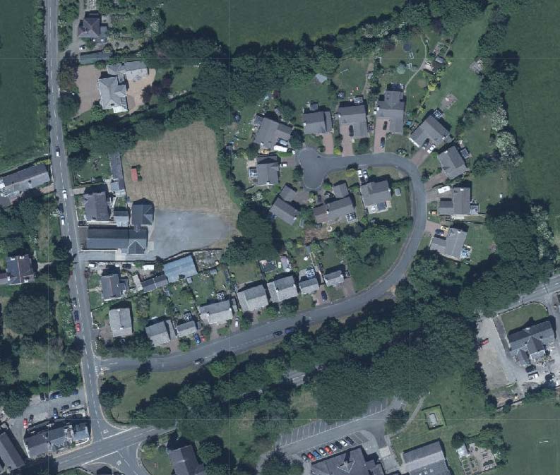
1.1 The site which is in two sections, is part of the estate of St. Stephen’s Meadow situated on the north eastern side of the A14 Clenagh Road which runs north from the A3 TT Course to Sandygate crossroads with the A13.
1.2 The estate comprises 21 dwellings - a mix of detached and two semi detached two storey houses with public open space. The estate has an access onto the A14 and the houses numbered 1-9 face south towards the TT Course, separated therefrom by the Public Open Space and a line of trees which are Registered (RA 1761 - LZ 61). This Registration is understood to relate to the designation of these trees as Woodland on the Isle of Man Planning Scheme (Development Plan) Order 1982 which conferred automatic Registered status on them, confirmed in the 1993 Tree Preservation Act.
Isle of Man Planning Scheme (Development Plan) Order 1982
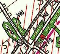
1.3 The estate was approved through a series of applications in the late 1990s/early 2000s (see Planning History. The site is as approved and includes an area of Public Open Space which runs parallel with and adjacent to the A3. An area immediately to the south west of plot 21 sits separate from the adjacent residential curtilage and is not part of the Public Open Space alongside.
1.4. The houses within the estate are visible from both the A3 and Clenagh Road but the view is softened by the existing trees which sit alongside the A3. The site is visually part of the established part of the village which sits around the Sulby crossroads with one of the two village public houses on one corner, which also provides a local shop, the former shop on the other side of the road and directly opposite the site to the south east is Sulby Methodist Church, a Registered Building (172) which sits alongside Sulby Primary School. The village hall is directly alongside the site to the west and which hosts a range of community events and recreation opportunities.
1.5 To the north east of the school is Sulby Old School (171) (now a dwelling (00/01660/GB, 00/01173/GA) and St. Stephen’s Church and former School room (170) behind (15/00794/A and 19/00087/B) and adjacent to (19/00989/B) which are new dwellings under construction. These sites are designated as Worship and Residential on the Sulby Local Plan.
Sarah Corlett Town Planning Consultancy Ltd Registered address: Ballachrink Croft, Ballacorey Road, Bride, Isle of Man IM7 4AW t: 07624 485517 e: [email protected] w: www.sarahcorlett.com Directors: Sarah Elizabeth Corlett Nicola Jane Corlett
Company Registration 134325C
A close-up section of a site plan showing green shaded areas, road lines, and red boundary markings.
Sarah Corlett Town Planning Consultancy Ltd Registered address: Ballachrink Croft, Ballacorey Road, Bride, Isle of Man IM7 4AW t: 07624 485517 e: [email protected] w: www.sarahcorlett.com Directors: Sarah Elizabeth Corlett Nicola Jane Corlett
Company Registration 134325C
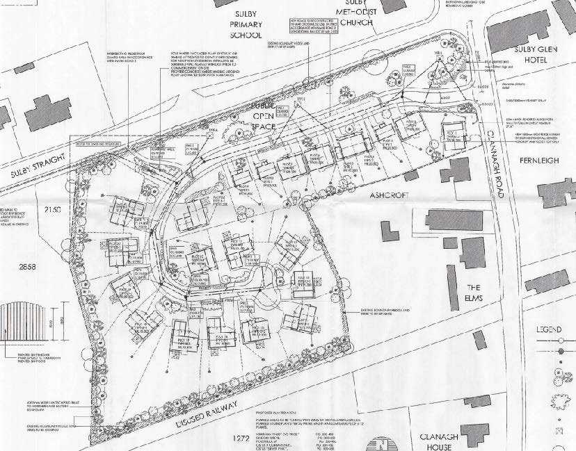
A black and white site plan illustrating a proposed housing development layout, featuring new dwelling footprints, a designated public open space, and surrounding existing structures like a school and church.Architectural elevation drawings displaying the front, rear, and side views of a proposed two-story dwelling with detailed material notes.
2.0 The proposal
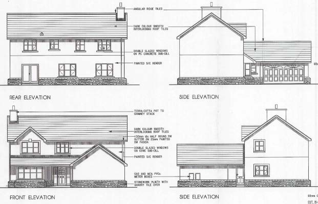
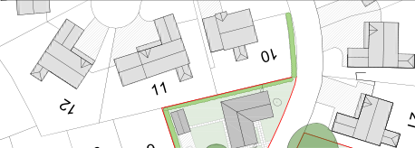
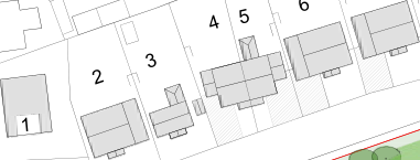
2.1 Proposed is the erection of a dwelling in the triangular area between plots 9 and 10. The proposed dwelling will be single storey and finished to match the dwellings elsewhere within the estate (stonework plinth, rendered walls and slate like roofing). A small, detached, single garage is also proposed.
2.2 The existing trees on site are to be retained and additional hedging is to be added along the frontage and reinforcing the existing planting along the boundaries shared with plots 9 and 10.
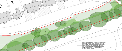
2.3 In addition, the areas of public open space are to be upgraded, the applicant having sought advice from Manx Wildlife Trust who recommend the replacement of the amenity grass with species rich grass and wild flower which will reduce annual maintenance and additional thicket planting will be provided to increase natural habitat. In the area to the south west of plot 21, a new minor woodland is proposed which will provide ecologically based public open space and an enhancement of the existing open areas within the site.
2.4 The applicant was approached in 2021 regarding the appearance of the area between plots 9 and 10 and its overgrown appearance where the vegetation which had been planted had grown considerably and was encroaching into the adjacent plots. This prompted further consideration of the future of this area together with discussions regarding ways of maintenance and enhancement of the existing areas of public open space and ecological biodiversity.
2.5 The existing estate provides 2,889 sq m of Public Open Space provided in the two areas (alongside the A3 and between plots 9 and 10). As proposed, there would be slightly more POS (2,981 sq m) and where the landscaped areas are adjacent to each other and part of a continuous line of trees.
7<br><br>11 Hall<br><br>CLENAGH ROAD<br><br>5<br><br>Elm View<br><br>3<br><br>Ashcroft<br><br>6<br><br>20<br><br>Sulby Chapel<br><br>4<br><br>10<br><br>1<br><br>2<br><br>12<br><br>21 9<br><br>8<br><br>NEW LARGE BOULDER CIRCLE<br><br>PUBLIC OPEN SPACE AREA TO BE UPGRADED WITH INPUT FROM MANX WILDLIFE TRUST. CHANGES TO INCLUDE REPLACEMENT OF AMENITY GRASS WITH SPECIES RICH GRASS AND WILD FLOWERS, WHICH WILL REDUCE ANNUAL MAINTENANCE REQUIREMENTS. ADDITIONAL THICKET PLANTING WILL ALSO BE PROVIDED TO INCREASE NATURAL HABITAT.<br><br>PROPOSED THICKET PLANTING. PLANTING TO AVOID EXISTING UNDERGROUND DRAINAGE<br><br>NEW MICRO WOODLAND PLANTING<br><br>EXISTING FOOTPATH LINK<br><br>
<br><br>EXISTING PUMPING STATION<br><br>
STATUS<br><br>PLANNING
STATUS<br><br>PLANNING
STATUS<br><br>PLANNING
STATUS<br><br>PLANNING
---
---
---
---
Middle river, Douglas, Isle of Man, IM2 1AL, British Isles Tel: 01624 631000 Fax: 01624 631001 Web: www.hartford.im e-mail: [email protected]<br><br>
Middle river, Douglas, Isle of Man, IM2 1AL, British Isles Tel: 01624 631000 Fax: 01624 631001 Web: www.hartford.im e-mail: [email protected]<br><br>
Middle river, Douglas, Isle of Man, IM2 1AL, British Isles Tel: 01624 631000 Fax: 01624 631001 Web: www.hartford.im e-mail: [email protected]<br><br>
Middle river, Douglas, Isle of Man, IM2 1AL, British Isles Tel: 01624 631000 Fax: 01624 631001 Web: www.hartford.im e-mail: [email protected]<br><br>
PROJECT<br><br>Proposed Development Sr Stephens Meadow Sulby
PROJECT<br><br>Proposed Development Sr Stephens Meadow Sulby
PROJECT<br><br>Proposed Development Sr Stephens Meadow Sulby
PROJECT<br><br>Proposed Development Sr Stephens Meadow Sulby
DRAWING Proposed Public Open Space
DRAWING Proposed Public Open Space
DRAWING Proposed Public Open Space
DRAWING Proposed Public Open Space
CONTRACT
Hart 59
Hart 59
Hart 59
DRAWN BY
CHECKED
DATE
September 2022
SCALE
1:250 @ A1
DRAWING No
04 REV
04 REV
-
<br><br>REVISIONS DATE<br><br>Proposed Site Plan - Public Open Space 1:250<br><br>5m 0 5m 10m 15m 20m 25m<br><br>1:250
---
Sarah Corlett Town Planning Consultancy Ltd Registered address: Ballachrink Croft, Ballacorey Road, Bride, Isle of Man IM7 4AW t: 07624 485517 e: [email protected] w: www.sarahcorlett.com Directors: Sarah Elizabeth Corlett Nicola Jane Corlett
Company Registration 134325C
A site plan showing the layout of existing properties numbered 10, 11, and 12 alongside a proposed development area with green landscaping.A technical site plan displaying numbered building footprints and land boundaries, likely illustrating a sequence of plots or structures.A site plan showing proposed building footprints and a designated public open space with tree planting.
<br><br>0 2m 3m 4m 5m<br><br>1:50<br><br>TO MATCH NEIGHBOURING DWELLINGS ARTIFICIAL SLATE PAINTED RENDER, NATURAL STONE PLINTH WHITE PVC FRAMED, DOUBLE GLAZED WHITE PVC WHITE SQUARE UPVC BLOCK PAVING
---
6000
6875 [53'-6"]
2.6 The Manx Wildlife Trust have advised that extending the thicket planing will increase biodiversity and reduce management burden in the long term which is important as the local authority do not wish to adopt or manage the public open space. They also note that the area alongside and parallel with the A3 is in full shade from the trees and also very dry so planted trees would establish slowly and survival is likely to be lower than desirable. They recommend that a 3m wide informal walkway is maintained through no planting within 4m of the sod bank and as the thicket planting grows, the grass int he walkway will disappear leaving a low maintenance informal soil path. They recommend removing the existing Grisilinia which is a Schedule 8 species and recommend hawthorn, hazel, holly, crab apple, elder and rowan with yellow rattle, oxeye daisy, common bird’s foot trefoil, common knapweed and red clover.
2.7 It is also proposed to introduce an informal play feature including large boulders or logs partially buried which will be low or no maintenance and visually and ecologically beneficial.
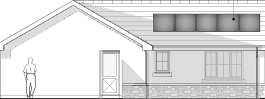
2.8 The house will be served by an air source heat pump with solar panels on the roof and will be built to at least current Building Control standards of thermal efficiency with provision for electric vehicle charging as well as the garage being able to safely and securely accommodate bicycles. The existing trees on the site will be retained and the proposal includes a significant area of garden and new planting.
Sarah Corlett Town Planning Consultancy Ltd Registered address: Ballachrink Croft, Ballacorey Road, Bride, Isle of Man IM7 4AW t: 07624 485517 e: [email protected] w: www.sarahcorlett.com Directors: Sarah Elizabeth Corlett Nicola Jane Corlett
Company Registration 134325C
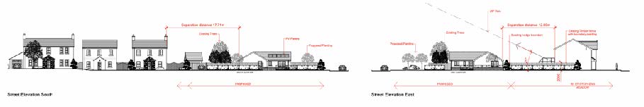
An architectural elevation drawing of a single-story dwelling featuring a pitched roof section and a flat roof area with solar panels, including a human figure for scale.Architectural street elevation drawings labeled 'Street Elevation South' and 'Street Elevation East' showing existing buildings, trees, and proposed structures with dimensional annotations.
3.0 Planning History 98/00390/A - approval in principle for residential development comprising 21 dwellings - approved on appeal
00/00259/B residential development comprising 21 swellings, roads, plots and sewers - approved on appeal
01/02383/B - erection of dwellings (substitution of approved house types) plots 1, 2, 6, 7, 10-21 - permitted 04/00832/B - creation of an additional plots and dwelling - refused for the following reason:
1. The proposed additional plot will reduce the level of open space provision provided within the existing approved development to the detriment of the residential amenity of the area.
2. The provision of an additional dwelling within the development would be contrary to the development brief for the area, as set out at paragraph 3.9 of the Sulby Local Plan which states that a maximum of 21 dwellings may be permitted.
Sarah Corlett Town Planning Consultancy Ltd Registered address: Ballachrink Croft, Ballacorey Road, Bride, Isle of Man IM7 4AW t: 07624 485517 e: [email protected] w: www.sarahcorlett.com Directors: Sarah Elizabeth Corlett Nicola Jane Corlett
Company Registration 134325C
4.0 Planning context
4.1 The site is designated for residential development in the Sulby Local Plan of 1990:
4.2 The development brief accompanying the Written Statement requires the development of the site to achieve, inter alia, the following: a maximum of 21 dwellings with some provision for first time buyers or young families, substantial landscaping proposals with special treatment to the site boundaries and the need to provide a continuation of the substantial tree line that exists along the main road and the provision of a village green at the south west corner of the site opposite the shop. It requires POS to be provided, including play facilities, of no less than 0.6ha.
4.3 The recently published draft Area Plan for the North and West includes there between plots 9 and 10 as Residential as part of St. Stephen’s Meadow with the proposed area of Public Open Space to the south west of plot 21, which was approved as residential curtilage for that property, being Open Space for Particular Purposes as is the larger area of original POS to the south west.
Sarah Corlett Town Planning Consultancy Ltd Registered address: Ballachrink Croft, Ballacorey Road, Bride, Isle of Man IM7 4AW t: 07624 485517 e: [email protected] w: www.sarahcorlett.com Directors: Sarah Elizabeth Corlett Nicola Jane Corlett
Company Registration 134325C
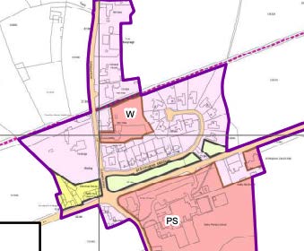
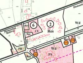
A planning map showing designated zones with colored overlays and boundary lines.A site plan showing land use designations such as residential (Res) and woodland (Wd) with numbered zones and boundary lines.
4.4 This area of proposed POS was propounded for residential development in the Area Plan process (Preliminary Publicity) but was not accepted ( site LR019) although no site assessment is presently online.
4.5 Sulby is recognised as a village in the Strategic Plan settlement hierarchy and where development “should maintain the existing settlement character and should be of an appropriate scale to meet local needs for housing and limited employment opportunities”. Spatial Policy 4 also recommends that Area Pans should ring the development boundaries of such settlements so as to maintain their character.
4.6 Development is directed towards sustainable locations - ie settlements - under Strategic Policies 1, 2 and 10, Spatial Policy 5 and Housing Policy 4 of the Strategic Plan.
4.7 As well as promoting sustainable development, Strategic Policy 1 also encourages development to: “make the best use of resources by:
(a) optimising the use of previously developed land, redundant buildings, unused and under-used land and buildings, and reusing scarce indigenous building materials and
(b) ensuring efficient use of sites, taking into account the needs for access, landscaping, open space(1) and amenity standards.”
4.8 As the site is within an area designated for residential use on the extant and emerging development plans, General Policy 2 is also considered applicable as follows:
Development which is in accordance with the land-use zoning and proposals in the appropriate Area Plan and with other policies of this Strategic Plan will normally be permitted, provided that the development:
(a) is in accordance with the design brief in the Area Plan where there is such a brief;
(b) respects the site and surroundings in terms of the siting, layout, scale, form, design and landscaping of buildings and the spaces around them;
(c) does not affect adversely the character of the surrounding landscape or townscape; (d) does not adversely affect the protected wildlife or locally important habitats on the site or adjacent land, including water courses;
(f) incorporates where possible existing topography and landscape features, particularly trees and sod banks;
(g) does not affect adversely the amenity of local residents or the character of the locality;
(h) provides satisfactory amenity standards in itself, including where appropriate safe and convenient access for all highway users, together with adequate parking, servicing and manoeuvring space;
(i) does not have an unacceptable effect on road safety or traffic flows on the local highways;
(j) can be provided with all necessary services;
(k) does not prejudice the use or development of adjoining land in accordance with the appropriate Area Plan;
(m) takes account of community and personal safety and security in the design of buildings and the spaces around them; and
(n) is designed having due regard to best practice in reducing energy consumption.
4.9 New dwellings should have two parking spaces provided to them and where there are more than 8 dwellings proposed, affordable housing should be provided.
4.10 Developments over 10 dwellings should also provide Public Open Space. In such developments, for each dwelling which provides three or more bedrooms, there should be provided 54 sq m of formal open space, 18 sq m of children’s play space and 24 sq m of amenity space. This would result, for the approved development, in a requirement for a total amount of POS of 2,016 sq m. With the additional dwelling now proposed, this would rise by 92 sq m to 2,112 sq m. The development as exists provides 2,889 sq m and the development as proposed would provide 2,981 sq m of POS.
4.11 Development must not result in any adverse impact on the living conditions of those in adjacent properties and guidance on how this may be assessed is set out in the Residential Design Guide.
4.12 Developments should also take account of Climate Change and involve sustainable construction and renewable energy where possible and practicable.
4.13 No part of the application site is at risk of flooding, within a Conservation Area or contains buildings which are Registered.
Sarah Corlett Town Planning Consultancy Ltd Registered address: Ballachrink Croft, Ballacorey Road, Bride, Isle of Man IM7 4AW t: 07624 485517 e: [email protected] w: www.sarahcorlett.com Directors: Sarah Elizabeth Corlett Nicola Jane Corlett
Company Registration 134325C
5.0 Assessment and conclusion
5.1 The site lies within the settlement boundary of a defined settlement, in a sustainable location within close walking distance of a shop, primary school, two churches and the village hall. The site is also close to the Claddagh Recreation area and numerous public footpaths including the former railway line which links Peel to Ramsey.
5.2 Development of this site as proposed would satisfy Strategic Policies 1, 2, 10, Spatial Policy 5 and Housing Policy 4 in terms of sustainable development.
5.3 The development of a single storey property on this site would not adversely affect the outlook or privacy of those in the adjacent properties 9 and 10, St. Stephen’s Meadow, satisfying the Residential Design Guide and would ensure the maintenance of the site and management of the planted boundaries. It would also add a new and different house type for the estate enhancing the attractiveness and interest of the estate.
5.4 Whilst the development would increase the density of development within the estate, it is relevant that the density prescribed for this site in the Local Plan was prior to the introduction of the Strategic Plan which seeks to optimise the development of sustainable sites and which also sets out the amounts of public open space which each development should provide. In this case, whilst the Sulby Local Plan required 0.6ha of POS, this was not provided within the approved layout and this is considerably in excess of the amounts of POS which are now expected by the Strategic Plan which is a more detailed and reliable indicator of need. What is proposed would not only comply with those standards, but would exceed them, as does the existing layout, and would increase the amount of POS currently available by at least the amount proportionate to one additional dwelling according to these standards.
5.5 In addition, the location of the replacement POS is more beneficial to biodiversity being located alongside existing woodland and enabling a continuation of the existing linear tree line. The proposed planting is as advised by Manx Wildlife Trust and the enhancement proposed will increase the biodiversity value of the site.
5.6 Whilst the applicant would be happy to provide seats and play equipment, this would not appear to be desirable as far as the local authority are concerned and as such, the application aims to enhance the wildlife value of the POS and including natural play opportunities, rather than making it an actively used area which also reflects the usage of the area to date.
5.7 The development will result in a more efficient and effective use of the site, in accordance with Strategic Policy 1 and will reduce the amount of greenfield land which may be considered necessary to develop to address local housing need and it is noted in the emerging Area Plan that a significant area has been designated for residential development to the south of the A3, further from the village centre and its facilities, than is this site. Unlike that site, no part of the application site is at risk of flooding and the proposed dwelling would not be particularly visible from the main road alongside the site. It is also clear from other applications in the village, including those around the Registered Buildings of the Methodist Church and school hall, that optimisation of land in this settlement, is to be considered positively. The proposal is consistent with that.
5.8 The development would comply with all of the relevant Strategic Plan policies, the land use designation in the emerging and adopted development plan and relevant guidance on design and would have a positive impact on biodiversity and the appearance of the area in general.
Sarah Corlett 14.09.22
Sarah Corlett Town Planning Consultancy Ltd Registered address: Ballachrink Croft, Ballacorey Road, Bride, Isle of Man IM7 4AW t: 07624 485517 e: [email protected] w: www.sarahcorlett.com Directors: Sarah Elizabeth Corlett Nicola Jane Corlett
Company Registration 134325C
Copyright in submitted documents remains with their authors. Request removal