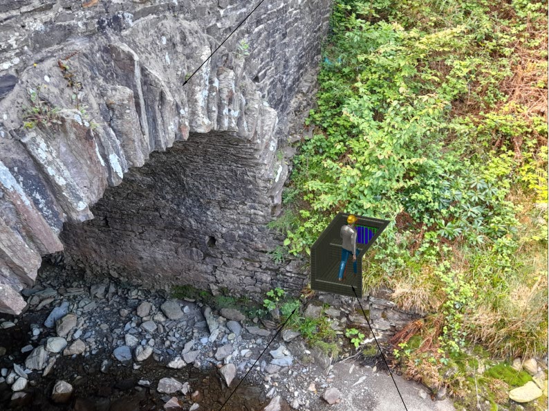
A site photograph of a stone arch bridge or culvert over a rocky stream bed, featuring a digital 3D overlay illustrating the proposed energy dissipater installation.
Flood Management Division
Mines Road to Laxey River
Planning Application Statement Of Case
Statement of Case Mines Road to Laxey River
Document Number: FMD/8.08.22/Mines Road Author: M. Cowin Owner: Status: Draft Document Revision Record
Version
Date
Author
Checked
Description
1.0
02/08/2022
M.Cowin
Initial Version
Document Location This document is only valid on the day it is printed. Please contact the document controller for location details or printing problems This is a Controlled Document.
1 Background As part of the wider Flood Alleviation schemes currently ongoing in the Laxey area, these works are required to alleviate flooding in the areas of Baldhoon and Mines Road and as identified in the Laxey Flood Alleviation Scheme Feasibility report published in August 2020. The current drainage discharges into the surface water system by Browns Café and then discharges into Laxey River downstream of the Road Bridge in Laxey Valley Gardens. There is currently flooding issues on this system as well as flooding at Ham and Egg terrace on the Snaefell track and around the Snaefell sheds.
2 Location and Brief Description of Proposed Development
The proposed design follows the recommendations of the flood studies, which improves the catchment of surface water discharging onto the Snaefell Mountain Railway corridor and Storage Shed area, and contains and discharges directly to the Laxey River.
The proposed system will take water coming from the Snaefell railway track, Snaefell Railway sheds and Baldhoon Road. This will relieve flooding on Baldhoon Road, Ham Egg Terrace and further along Mines road in the area of the fire Station where it floods in heavy rain.
This application is for the outfall into the river only, just upstream of the Glen Mooar where the construction of an impact basin will be slightly above the existing bank levels. All other works associated with this development shall be undertaken in accordance with the relevant Permitted development Orders.
3 Political Policy The Council of Ministers programme for Government 2016 – 2021 states the strategic objectives of Tynwald over a five year period. On page 11 of the document, one of the policy statements declares that… “We will continue to invest in sea defences and in reducing flooding and coastal erosion risks for those areas identified as high risk in our national strategy”
The development of this strategy for the Isle of Man, which covers three sources of flooding and coastal erosion, is a pioneering step for the Island and will contribute to the economic, environmental and social resilience of the Isle of Man to current and future climate risks. The report informs the Isle of Man Government’s first strategy, collectively assessing flooding and coastal erosion risks, identifying the locations at most risk and suggesting potential responses to increase the resilience of these locations.
The Strategy Evidence Report was developed by JBA Consulting on behalf of the Department for Environment, Food and Agriculture (DEFA) and a wider Strategy Steering Group including representatives from the Department of Infrastructure (DOI) and Manx Utilities (MUA). The report is intended to comply with and assist in the delivery of key relevant policy, including the Mid-Term Report from the Council of Ministers on the Agenda for Change, 2014; Isle of Man Government Policies on adapting to and mitigating Climatic Change, 2014; Isle of Man Government Policies on adapting to and mitigating Climatic Challenges and Sustainable Development, 2015; The Island Development Plan, 2016; The Isle of Man Biodiversity Strategy, 2015; and the Regional Sewage Treatment Strategy, 2009.
4 Planning and other Policy Framework The River Bank falls within the scope of The Laxey and Lonan Area Plan (2005) and falls within the Laxey Conservation Area – Map 6 referred to in the Town and Country (Planning Development) Order 1990.
5 Ecological Impact The Department have sought advice from an Ecologist (MWT) who has visited the site. The section of River Bank where the outfall is to be constructed is heavily vegetated with small trees and shrubs, none of which are of a size that would require a license for removal. Whilst the trees and shrubs provide potential bird nesting sites it is intended that the works would be carried out between October and March to avoid the nesting season. A number of Schedule 8 invasive species (montbretia and cotoneaster) have been identified. An ecologist will be employed during vegetation removal to ensure that these species are appropriately removed and segregated for disposal/incineration. The area of bank will be reinstated with existing soils to encourage regrowth of native shrubs. A potential bat roosting feature has been identified in the existing bridge masonry adjacent to the proposed outfall, the works would not directly impact this PRF but are in close proximity. An emergence survey will be carried out prior to end of August; should the presence of Bats be identified suitable working methods (to be agreed with MWT) will be employed to avoid Bat disturbance. The impact basis is design to be constructed above river level, access into the river will not be required, however, consent to undertake the works will be sought from DEFA Fisheries.
Copyright in submitted documents remains with their authors. Request removal