PLANNING STATEMENT IN SUPPORT OF THE DEVELOPMENT OF LAND TO THE SOUTH OF SPRINGFIELD TERRACE, FOXDALE
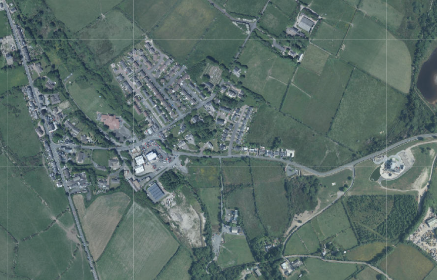
Aerial photograph
Aerial map view showing a rural settlement surrounded by agricultural fields and roads with grid overlays.
1.0 Introduction
1.1 This site, which is approximately 5 acres (1.9ha) lies to the south of the A24 road which runs from Douglas at the Cooil roundabout to Foxdale, ending at its junction with the A3 Foxdale Road. The site has to its north, the housing of Springfield Terrace, to the south is the residential property and stables of Kiondhooag: to the west is land which is designated on the adopted Foxdale Local Plan 1999 as residential and which had until relatively recently, planning approval for residential development (see Planning History). To the east is a small cleared area which is a car park for the property opposite and to the east of this is an area known locally as The Deads which has relatively recently been reclaimed as open space, in conjunction with the reclamation of further land to the north east which is now a residential property, Louisa House.
1.2 The site is presently unused and unmanaged with scrub vegetation with the land rising upward to the south. The applicant also controls additional land to the south east which is shown in the submitted plans, in blue.
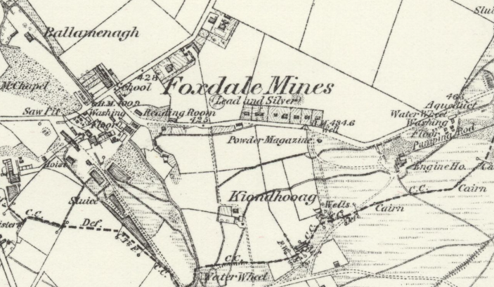
1.3 The site lies within an area which was formerly mined although the area does not appear to contain shafts or mining structures which are shown below in the land to the west and east. The 1868 County Series maps show how industrious this area was at that time and the myriad of shafts, tunnels, mines and the infrastructure that went along with them - the powder magazines, water wheels, hoists, washing floors, saw pits, sluices, pumping rods, aqueduct, engine houses and wells (see below) some of which still exist and have archaeological value.
1.4 Much of this land has been developed, incorporating restoration of former mining areas, the most recent of which is at the Louisa Mine site on which there is now a dwelling - Louisa House - which was built in the 2010s (see Planning History) and incorporated the restoration of the land on both sides of the minor road linking the A24 with the Stoney Mountain Road.
2.0 Planning policy
2.1 Foxdale is a Service Village within the settlement hierarchy in the Strategic Plan. Within the study area, the other Service Villages are Jurby, Andreas, Kirk Michael, and St. John’s. This level falls below Douglas and the study area Service Centres of Peel and Ramsey in the north and west but above the “remaining villages” in the north and west (Bride, Sulby, Ballaugh, Glen Mona, Dalby). The Spatial Strategy, Spatial Policy 3 states that in Service Villages “Area Plans will define the development boundaries of such villages so as to maintain and where appropriate increase employment opportunities. Housing should be provided to meet local needs and in appropriate cases to broaden the choice of location of housing.”
Foxdale Local Plan
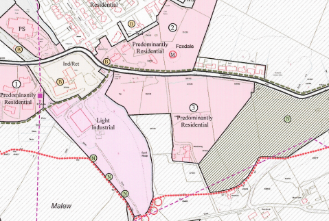
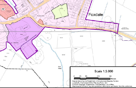
2.2 The site is designated for Predominantly Residential use and development on the Foxdale Local Plan adopted in 1999 and which remains the extant development plan for this site. The Foxdale Local Plan covers land which falls within both Patrick and Malew. The Malew section is now covered by the Area Plan for the South which was adopted in 2013.
2.3 The land to the west is also designated for residential development on the Local Plan with light industrial land to the south west of that. The land opposite, Springfield Terrace is identified as existing residential. The rest of the land surrounding the site is not designated for a particular purpose and therefore there is a presumption against development in these areas.
2.4 The Foxdale Local Plan considered the future of the village in some detail and provides a lot of information about the contamination of some parts of the village and also the archaeological and wildlife interest of some of its areas and the development brief for this site includes conditions relating to the phasing of the development, connection to the main sewer under gravity feed, the density becoming gradually less as it approaches the edges of the site bordering countryside, acknowledgement of Kiondhooag and its use as a dwelling, demonstration that the site is not contaminated and if it is, measures to address this, pipework which will not allow contaminated material to enter the watercourse, the inclusion of children’s play space and the design reflecting the more traditional properties in the village (paragraph 3.54). Area Plan for the North and West
2.5 The Preliminary Publicity stage invited suggestions for where new development may take place: it would not appear that any submissions were made in respect of this site although there were for land to the south and south west and these sites were assessed (PTR007 and PTR006). The site is shown as a site, PTR004 although there is no submission other than this reference and a map. The assessment online is for a different site in Ramsey so at the current time it is not possible to see why the continued designation of this site as residential was not accepted. This has been queried with Cabinet Office but no updated assessment has yet been posted.
A planning zoning map displaying land use designations such as 'Predominantly Residential' and 'Light Industrial' with road networks and location names like Foxdale and Malew.
2.6 The first response to this in the Preliminary Publicity stage of the Area Plan was a document and the definition of settlement boundaries (see map above) which excludes this site from development along with the site to the west and the industrial land to the south.
2.7 The draft Area Plan for the North and West was published in June 2022. This re-designates the former proposed residential and industrial land to open space (see below). The assessments for the two areas to the south of Springfield Terrace and the formerly industrial land to the south west are now online and explain that in respect of the industrial land, that it is contaminated and cannot be satisfactorily addressed as part of the development and that it has been identified as having potential nature conservation value.
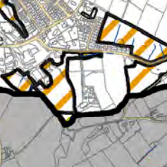
2.8 On the Infrastructural Constraints Map 1bw, the district road is highlighted (it is not clear why this is a constraint). On the Environmental Constraints map 1aw there are no constraints identified (see below).
This image shows a site location map or plan of a village settlement, featuring purple boundary lines and yellow highlighted roads.A planning site location map displaying land parcels with purple and green highlighted boundaries overlaid on a topographical base map.
2.11 The Strategic Plan encourages development in sustainable areas and making use of existing infrastructure (Strategic Policy 1, 2 and 10, Spatial Policy 5, Housing Policy 4 and Transport Policy 1 as well as addressing Climate Change in accordance with the Climate Change Act 2021. It also refers to environmental enhancement as follows:
7.21.1 In addition to the need for protection there is also a need to carry out enhancements to the natural environment if a sustainable vision for the Isle of Man is to be achieved. Opportunities for environmental enhancement, such as tree planting, the removal of eyesores and the management of habitats will need to be identified in Area Plans with the full involvement and support of local communities. Such opportunities may include former mining areas which have been or are in the process of being reclaimed. Appropriate reclamation should protect or enhance features of industrial or archaeological significance.
Environment Policy 27: The Department will seek to enhance the natural environment, including sites contaminated by former mine workings, along with other Government Departments, local communities, the private sector and all appropriate agencies in order to ensure the appropriate reclamation, water management, planting of appropriate tree species, the management of special habitats including aquatic habitats and the removal of eyesores.
2.12 The Foxdale Local Plan identifies areas of potential contamination and this site is shown as being partly as having “slight possibility of elevated heavy metal concentration of other geotechnical/soil/water factors above background levels” and partly as having “evidence of a limited degree of heavy metal contamination that may limit end use unless restored”.
2.13 The Plan also recognises the potential for attaining the reclamation of the land alongside that has now been reclaimed as part of the Louisa House scheme as at that time all of this land was in the same ownership.
2.14 The Plan acknowledges the importance to the de-contamination of the area of separating contaminated ground from water passing through the site: it states at 2.15 “The biggest environmental hazard in Foxdale results from the interplay of drainage water and contaminated spoil. Attendance to the drainage network is therefore of paramount importance”. It then goes on to discuss and promote a catchment-wide remediation which should be formulated by Government to prevent contact between mine spoil and water courses and should be implemented “as a matter of urgency”.
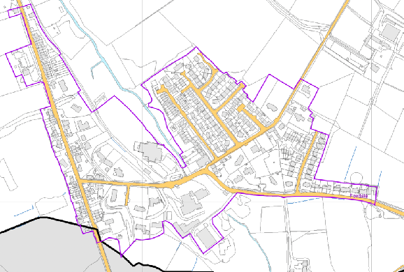
A site plan illustrating a proposed residential development area marked with thick black boundaries and orange hatching. The map shows the site's location relative to existing housing to the north and surrounding agricultural fields to the south.
Landscape Character Assessment
2.15 This was a study which was commissioned by the Department to ultimately replace the areas of High Landscape or Coastal Value and Scenic Significance on the Isle of Man Planning Scheme (Development Plan) Order 1982 with landscape types. This includes the application site in an area of Incised Slopes - Foxdale - where there is a detailed description of the area (see Appendix Two) and the strategy is (my underlining):
“to conserve and enhance the character, quality and distinctiveness of the area, with its wooded valley bottoms, its strong geometric field pattern side lineated by Manx hedges, its numerous traditional buildings and its network of small roads and lanes. The strategy should also include the restoration of landscapes disturbed by former mining activities.The overall strategy should be to conserve and enhance the character, quality and distinctiveness of the area, with its wooded valley bottoms, its strong geometric field pattern side lineated by Manx hedges, its numerous traditional buildings and its network of small roads and lanes. The strategy should also include the restoration of landscapes disturbed by former mining activities.”
Other policies and constraints
2.16 There are no Registered Buildings or Registered Trees on the site and it does not lie within an existing or proposed Conservation Area and is not within an area identified as being at risk of flooding.
3.0 Planning History
3.1 The development of the house on the area formerly known as Louisa Mine or “The Deads” was approved under 12/01053/ B and 13/00387/B which included the restoration of the land on the western side of the minor road leading up to Stoney Mountain Road which was subsequently also the subject of its own application for restoration - 16/01376/B.
3.2 The land to the west of the site had permission for the development of 24 dwellings under 15/00978/B. This permission may be taken up until 13/08/2022 although there are conditions which require to be satisfied before works commence on site (a site investigation into ground conditions and a landscaping scheme - conditions 11 and 5 respectively).
3.3 The site itself has been approved for residential development - 14/00295/A, 16/00751/B which extended the permission for the submission of the reserved matters to 05/09/2018 so this approval now has also expired. The conditions of approval for 16/00751/B are as follows:
1. Details of the siting, design, external appearance, internal layout and landscaping (hereinafter called "the reserved matters") shall be submitted to and approved in writing by the Planning Authority before any development is commenced and thereafter the development shall only be carried out in accordance with the details as approved. Reason: To comply with the Town and Country Planning (Development Procedure)(No2) Order 2013.
2. Application for approval of the reserved matters shall be made to the Department before the expiration of two years from the date of this approval and thereafter the development shall only be carried out in accordance with the details as approved. Reason: To avoid the accumulation of unimplemented planning approvals.
3. The development hereby approved shall be begun either before the expiration of four years from the date of this approval or before the expiration of two years from the date of approval of the last of the reserved matters.
Reason: To comply with article 14 of the Town and Country Planning (Development Procedure) (No2) Order 2013.
4. This approval relates to the principle of the residential development of the site and the construction of access from the A24 for a distance of 20m into the site, as shown in drawing 1400/01/01 revision A received on 28th June, 2016.
REASON: It has not been demonstrated that the plot development as shown will result in a soft edge to the development as required by the Foxdale Local Plan and that there is acceptable separation distances between the properties and the proposed tree planting. As such, no approval is hereby granted to any number or layout of plots.
5. Any residential development on the site must demonstrate that affordable housing is provided at a ratio of 25% of the overall number of plots. REASON: To accord with Housing Policy 5 of the Strategic Plan.
6. No development may commence on site until such times as there is in place an approved facility of disposing of surface water from the site, including any works which may be required to be undertaken off site by third parties.
REASON: The approved plans show there to be remedial works carried out off site by third parties in order for the proposed diverted watercourse to be effective.
7. Any residential development on the site must be designed such as to provide a softer edge to the east of the site than is shown with more space dedicated to tree planting within the red line area and more space around each tree than is shown on the submitted drawings to ensure that trees are not inappropriately close to proposed dwellings such as would threaten the long term future of the tree.
REASON: To accord with the principles of the Foxdale Local Plan and to have an acceptable environmental impact.
This approval relates to drawing 1400/01/01 received on 28th June, 2016.
NOTE The applicant is advised to consult Manx National Heritage in respect of any industrial archaeological interest within the site, prior to the commencement of works to ensure that any features of interest are recorded.
3.4 The site Ito the south west of Kiondhooag has been the subject of one application for industrial development and was approved: 87/04475/A - approval in principle to Phase 1 development of 10 industrial warehouse units. The existing unit on this site was approved under 88/01161/B which included a detailed landscaping plan which showed the other previously approved units.
3.5 These applications may be viewed online.
4.0 Support for the development of the site for residential use and development
4.1 The site, along with the land to the immediate west has been designated for residential development since 1999 when the Foxdale Local Plan was adopted. The planning history of both pieces of land indicate a desire for development although none of the planning approvals were taken up. Foxdale is identified in the Strategic Plan as a settlement where development should not only satisfy local need but add to the opportunities for housing and employment. It is ideally situated in respect of proximity to the Isle of Man Airport and Douglas and already has an established employment and population base.
4.2 Recent residential development in Foxdale has contributed not only to additional housing opportunities for an expanding local population but also has broadened the housing choice, as is referred to in the Strategic Plan settlement hierarchy and Spatial Policy 3. Industrial development has added to local employment opportunities and has seen the revitalisation of the village centre with new businesses, new buildings and reclamation of previously developed land. This work has also secured sites with geotechnical issues due to their mining history. The village has seen previously contaminated sites redeveloped and improved and this site is no different.
4.3 The Foxdale Local Plan is clear that any development of this land must be accompanied by appropriate surveys and information to address any geotechnical or contamination issues and is also clear that the interaction of water through contaminated sites is a significant factor in addressing the contaminated areas of the village. The development of this site would address this as well as providing the potential for enhancement of the biodiversity and archaeological interest of the site (also as highlighted in the Local Plan).
4.4 The draft Area Plan has reduced the amount of residential land available in the study area through the de-designation of various areas of previously designated land to open space which is unusual for a development plan which would normally be expected to provide enhanced and expanded development opportunities. This is particularly unusual given the recent publication of Government’s draft Economic Strategy which states an objective of a population increase to 100,000 by 2037 and expanded employment and economic opportunities and “suitable and affordable housing” and noting that one of the current challenges is “access to housing”.
4.5 The Area Plan has to work to the population and housing projections within the Strategic Plan, as required by Town and Country Planning Act 1999 (Section 2(4) although as they only project to 2026, and to an end population by that time of 93,526. It is notable and of concern that the draft Area Plan proposes a net loss of residential land in the two Service Centres (Peel and Ramsey) compared with the extant local plans, slight gain in the Service Village of St. John’s, no significant gain in the Service Village of Andreas (where previously designated land has been de-zoned and a new site has been added in) and net loss residential provision in Jurby, Kirk Michael and Foxdale. However, there has been a significant increase in residential land designation in two of the “remaining villages” of Ballaugh and Sulby where “development should maintain the settlement character and should be of an appropriate scale to meet local needs for housing and limited employment opportunities”. Glen Mona, Glen Maye, Dalby and Bride which are at the same level as Ballaugh and Sulby in the settlement hierarchy, do not have any new housing afforded to them so there does not appear to be an equitable spread of housing within the settlements.
4.6 In respect of the overall amount of housing proposed in the Area Plan, this is also an area of concern and dispute and submissions are being made in this respect to Cabinet Office. A Planning Inspector once stated “A Planning Authority has little or no power of itself to build homes (though the Government in a wider sense can) but only to create development opportunities. That is the only target open to the planning system, and is treated as such in the Residential Land Availability reports. But on any sensible reading, the aim behind this target is for 6,000 additional dwellings to be built over the Plan period. No one can live in a development opportunity: land allocations, approvals and policies regarding windfalls and conversions are means to an end.” (13/91289/B paragraph 64). In order to deliver even the amount of housing indicated in the Strategic Plan, never mind the increased amount referred to in the draft Economic Strategy, one could assume that land equivalent to more than the stated amount of housing needs to be designated so that it can be regarded that the desired amount will be attained with any degree of certainty. That same inspector also stated that “There is also what might be called a market ceiling. Developers…will not build dwellings with no expectation of being able to sell or let them.” (Paragraph 69). Another inspector comments in respect of housing delivery: “In order to meet Strategic Plan housing target for the West it seems wrong to resist a housing scheme on a site located for housing since 1989 and to instead hope to permit housing from unpredictable windfalls and conversions. The Planning Authority’s preferred approach of hoping to permit windfalls and conversion instead of permitting development on an allocation site, means that no affordable houses would be provided in the West…
Furthermore there is nothing in the Strategic Plan that supports the argument that a small surplus of housing provision in the island, or a part of the island, would be harmful or inappropriate…” (09/00521/B)
4.7 If the plan area needs the amount of housing which would result from the additional sites in Andreas, Sulby and Ballaugh, the priority should be given firstly to Ramsey and Peel and then to Andreas, Jurby, Foxdale and Kirk Michael before significant areas in the lowest level villages are designated for development, particularly in the case of sites which would be out of scale with existing development alongside (Sulby) or discharging onto the TT Course (Ballaugh). In both of these cases the sites do not lie within the existing settlement boundaries as originally defined in the Preliminary Publicity stage of the process. Submissions are being made in respect of this to the Cabinet Office as part of the Area Plan process. The draft Plan is not in general conformity with the Strategic Plan as it is required to be by Town and Country Planning Act 1999 as the approach to the distribution of housing (and employment) does not follow the settlement hierarchy as set out in the Strategic Plan.
4.8 The purpose of including these arguments in this planning statement is not to invite discussion over the merits of the Area Plan for the North and West but only to demonstrate that there are clear failings in the plan and significant differences of view on its contents and methodology. As such, whilst the Area Plan has emerged as far as a draft Plan, the weight to be afforded to it at this stage should reflect the distinct possibility that its contents will change: as the Head of Planning Policy explained in a virtual webinar on the Area Plan on 11th July, 2022, sites that are currently in may come out and sites that are currently out may come in as a result of reconsideration of the submissions made to the draft Plan. As such, at the moment, any decision on development within Foxdale should rely principally upon the designation in the adopted Local Plan.
4.9 Notwithstanding the above, the Foxdale Local Plan is clear that the interplay of water with contaminated land is something to be addressed without delay and this is not likely to happen without development potential of any contaminated land. The Foxdale Local Plan understood this and designated land for industrial and residential development with clear parameters on how this should occur and what safeguards should be employed. The Local Plan considers that the site has “slight possibility of elevated heavy metal concentration of other geotechnical/soil/water factors above background levels” and partly as having “evidence of a limited degree of heavy metal contamination that may limit end use unless restored”. If land is not retained for development in Foxdale then this is unlikely to ever happen and the works undertaken elsewhere in the village to address this as part of relatively recent developments, will be less effective than it could be if it were part of a wider scale remediation programme for the village.
4.10 The development of this site would continue to contribute to the de-contamination of the village as well as providing housing opportunities for the area in general within a Service Village which has its own school, church and employment opportunities - all in accordance with the Strategic Plan objectives and policies. It has a former railway, now public footpath running through the village and access to leisure and recreation opportunities relatively close by (South Barrule Plantation, Archallagan plantation). The local plan considered that “development of some of the area opposite Springfield Terrace to Kiondhooag would not be detrimental to the policy of containing new development within an establish village perimeter” and goes on to make suggestions about the layout and how it should be sensitive to its location at the edge of the village.
4.11 We believe that this continues to be the case and that development of this site should be permitted as proposed in accordance with the extant adopted development plan for the site and subject to the conditions which were applied previously to the principle of the development of the site.
Sarah Corlett 01.09.22
Appendix One
Landscape Character Assessment - Incised Slopes - Foxdale
D11 FOXDALE Key Characteristics
• A rural landscape with a settled farmland character
• Wide wooded river valley with various settlements along the A3 and A24.
• Small-scale rectilinear fields in valley bottom around settlements becoming larger and fragmented with strong geometric pattern around Mount Pleasant.
• Predominantly slate houses with front walls consisting of slate and white granite tops. • Undulating farmland with large arable and pastoral fields with intact field boundaries.
• Gently rounded hills.
• Large Archallagan coniferous plantation on abrupt edge on rounded hilltop.
• Hill farms surrounded by trees.
• Irregular sized and shaped fields of rough pasture on increasingly steep slopes that lead up to the Southern Uplands.
• Fields generally enclosed by robust Manx hedgerows, with gorse in upper parts of area and occasional trees in valley bottom.
• Moderate sense of enclosure provided by surrounding slopes.
• Sense of tranquillity reduced in areas close to the busy A3/A24.
• Legacy of abandoned mines and quarries, with spoiled areas and disused buildings.
• An evocative sense of abandoned fields on upper slopes.
• Kionslieu Reservoir and Eairy Dam waterbodies
• Well vegetated river corridor descending to Greeba Valley and St. John’s.
Overall Character Description The area consists predominantly of settled undulating farmland on gently sloping valley sides and the relatively steep slopes that lead up to the Southern Uplands, from where numerous small tributaries, such as Struan Barrule, drain to fill the Eairy Dam and Kionslieu reservoir that subsequently flow into the valley bottom river.
The gently rounded hilltop covered by the large Archallagan coniferous plantation with abrupt edges is surrounded by an extensive area of farmland and pasture, divided by strong hedgerows of Manx hedges with gorse that creates a strong geometric field pattern. Large rectangular fields with deciduous trees contained within the field boundaries, in addition to the trees that surround the scattered farm houses and out buildings in places, such as Kerrowdhoo Farm, create an enclosed but settled feel. The enclosed character is enhanced by the numerous small lanes with tall grassed Manx hedges that predominantly follow the valley contours. Relatively small rectilinear fields around settlements. Sense of tranquillity reduced by busy A3/A24 highways.
Fragmented and often dense deciduous woodland occupies the Foxdale valley bottom, along which the A24 and A3 road corridors run. The settlement of Foxdale with its modern extension is located in the valley bottom at the A24/A3 junction. Settlements in the valley generally comprise a mixture of low terraced and detached houses, constructed predominantly of slate. White granite topped front walls of the houses run parallel to the road corridor and river. Around Lower Foxdale, the watercourse is surrounded by lush riparian vegetation and deciduous woodland.
Key Views
• Open views down and across the valley towards St. Johns, the Greeba Valley and beyond to the peaks of the Northern Uplands from areas of higher ground
• Enclosed views up to the surrounding Southern Upland areas and Stoney Mountain Plantation Historic Features
• Disused mines and quarries and mining features.
• Giant’s grave.
• Keeill. Ecological Features
• Farmland grassland habitats.
• Marginal periphery moorland habitats at edges of coniferous plantations and on upper valley slopes.
• Mature network of hedgerows containing deciduous trees in field boundaries.
• Aquatic and waterside habitats along river’s course and in the reservoirs.
• Dense riparian woodland in valley bottom with deciduous woodland along valley sides. Evaluation of Inherent Landscape Sensitivities
• Valley bottom and riverside woodland.
• Ecological value of the aquatic ecosystem with riparian habitats.
• Strongly geometric pattern of fields with Manx hedges.
• Numerous small lanes with grassed Manx hedges.
• Sites of archaeological importance.
• Scattered hill farms fringed by trees on upper slopes.
Landscape Strategy The overall strategy should be to conserve and enhance the character, quality and distinctiveness of the area, with its wooded valley bottoms, its strong geometric field pattern side lineated by Manx hedges, its numerous traditional buildings and its network of small roads and lanes. The strategy should also include the restoration of landscapes disturbed by former mining activities.
Copyright in submitted documents remains with their authors. Request removal