Loading document...
Received 160113 13 00054 DEPARTMENT OF INFRASTRUCTURE PLANNING and BUILDING CONTROL DIVISION Town and Country Planning, LLP
For: Yorkfields Ltd.
November 2010
RECEIVED ON 16 JAN 2013 DEPARTMENT OF INFRASTRUCTURE
Report reference R1534-R01-v2
| Decision | ||
| Appeal |
Report Title: Land at Foxdale, Isle of Man Contamination Review and Remedial Strategy Client: Yorkfields Ltd. Report Reference Number: R1534-R01 Report Status: FINAL Version: v2 Report Date: 15th November 2010
| Name | Position | Signature | Date | |
|---|---|---|---|---|
| Author | A F Smith BSc, PhD, MCIWM, SiLC | Member | ### | 15/11/2010 |
| Checked | K E Hawkins BSc MSc CEnv MIEMA | Member | ### | 15/11/2010 |
| Version | Report Status | Date | Details of Revision |
|---|---|---|---|
| v1 | Draft | 14/10/2010 | original draft, issued for client comments |
| v2 | Final | 15/11/2010 | final for use |
For: Yorkfields Ltd.
November 2010
D01 Sample Positions D02 Site Features
Soil Data Summary and Statistics
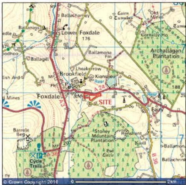
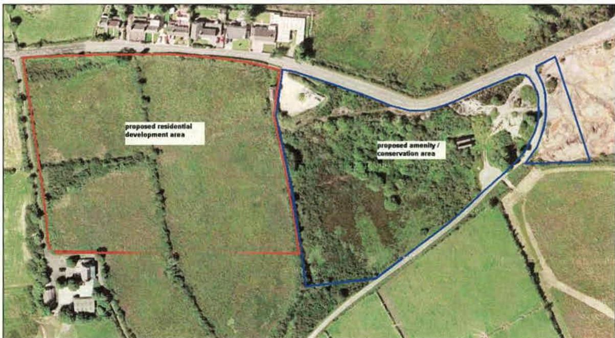
This report is commissioned by Yorkfields Ltd. as owners of land being considered for development to residential housing and conservation / amenity uses on and adjacent to the former Louisa Lead Mine, Foxdale, Isle of Man. The report provides a review of all available information on soil contamination within the site, which comprises two parts. The western part, covering about 2.26 ha, is enclosed fields used for grazing. The eastern part, covering about 1.97 ha, is scrubland or heathland with a relatively small area of mining remains and mine spoil forming the western side of the Louisa Mine. The fields have been identified as potentially suitable for residential development, whilst the eastern area has potential for management for nature conservation and use as a visitor attraction.
Investigations were carried out in the 1980s and 90s of the land, involving the collection of soil samples for chemical analysis. Contamination of the western area was limited to lead, which could pose a risk to future residents within gardens, and to a lesser extent, zinc which might affect garden plants. The sources of the contamination could be from the accumulated deposition of wind-blown metalliferous dust from nearby areas of exposed fine-grained mining wastes over many years, or could arise from natural weathering of minerals within the bedrock. The contamination identified does not prevent residential development, but will require the removal and replacement of a cover layer of soil within future garden areas. The existing soil might be re-used for the reclamation of mining wastes in less sensitive areas of the site or elsewhere. Typically, a clean soil cover 600mm thick should be appropriate within future residential gardens.
The eastern part of the site is more contaminated, with lead, cadmium and zinc concentrations particularly concentrated within deposits of exposed mine spoil which are sufficiently toxic, unstable or poor in nutrients to prevent vegetation establishment, and which pose a risk to site visitors or local residents. The bare mine wastes continue to be eroded into the stream course causing water pollution. The requirement here is to isolate and protect the mine wastes against erosion, involving the stabilisation of slopes and bare ground below soil and vegetation cover, and the diversion or culverting of drainage.
Risks posed by shallow underground mine-workings are likely to be low within the proposed residential development area, which is offset from the recorded area of historical workings, although precautionary investigations have been recommended. A previously capped mine shaft is present towards the eastern end of the proposed conservation / amenity area, and it is recommended that the capping to this be re-constructed to modern standards, and the area restored to enhance its potential.
Recommendations for further investigations to support the development of a remedial strategy and design for the site are provided.
| Address | off East Foxdale Road, Foxdale, Isle of Man |
|---|---|
| National Grid Reference | SC 285 779 |
| Local Authority | Parish of Patrick |
| Site Area | ~4.23 ha total ~2.26 ha fields / openland ~1.97 ha former Louisa Mine |
| Boundaries | north wooden post and wire stock fencing east unfenced south bank and hedgerow to southwest, elsewhere unfenced west bank and hedgerow |
| Neighbouring land | north East Foxdale Road, with Springfield Terrace housing to northwest; grazing land to northeast east open disused scrubland and mining wastes (Louisa Mine) south open grazing land with Stoney Mountain Road to south east, and Kiondhooag house to southwest west access road to Kiondhooag, with open field and Foxdale Village beyond |
1.1. Smith Grant LLP (SGP) was instructed by Mr Rodney Spragg of Yorkfields Ltd., which owns land at Foxdale Village, to undertake a review of previous investigations and available site information and to provide a recommended strategy to support the environmental improvement of the subject land, including the proposed development to residential housing of one part.
1.2. Site details are:
Site location plan
1.3. The site can be divided into two roughly equal parts, comprising an area of grassed fields to the west, and part of the former Louisa Lead Mine to the east. The mine site to the east is bounded by Stoney Mountain Road, with a separate area of Yorkfields land lying to the east of the road. An aerial photograph of the site and its surroundings with boundaries is provided below:
1.4. Lead mining can result in characteristic forms of metal contamination across the land occupied by and adjacent to former mine sites. The contamination results from the deposits of mining wastes, and dispersal of metals within stream sediments and as a result of dust blow from fine wastes ("fines, or slimes") from ore processing and concentration. Commonly, the key pollutants are lead and cadmium, which are of principal significance for human and animal health, and zinc, principally of significance for vegetation and aquatic ecosystems. As mineral deposits will inevitably be present in the bedrock, natural weathering of these can also result in elevated background concentrations of metals in superficial soils and stream sediments.
1.5. This report describes the known history and environmental setting of the site, presents the results of previous investigations and assessments, and provides a risk assessment for the proposed future uses of the land. Finally, recommendations are provided for a remedial strategy to enable the environmental improvement and beneficial future use of the site. The assessment generally follows the guidance in DEFRA / Environment Agency publication CLR 11 "Model Procedures for the Management of Land Contamination", 2004.
| author and reference | purpose and content |
|---|---|
| Richards, Moorehead and Laing Ltd. "Foxdale Land Reclamation Scheme Survey of Existing Heavy-metal Contamination", January 1986, for Isle of Man Local Government Board, ref: 1123 | desk study review of potential contamination from Foxdale Mines, including Louisa Mine site, with general recommendations for engineering reclamation and future land uses |
| Wolverhampton Polytechnic "Environmental Report on the Area of Upper Foxdale, Isle of Man", December 1991, for Department of Local Government and Environment | review of previous investigations and field by field assessment of contamination levels and risks, with recommendations for future land uses in context of Foxdale Village Plan, includes consideration of the subject site |
| RPS Environmental Sciences Ltd. "Foxdale East Mine Site Assessment and Reclamation Feasibility Study", June 1989, for R Cookson & Son Ltd. ref. ES145B | Geo-environmental site investigation including soil sample collection and analysis of eastern half of the subject site, and recommendations for remediation |
| Smith Grant Partnership "Foxdale Village Geochemical Study", June 1994, for SGP Ltd. | Soil analysis factual report for the subject site extending between Kiondhoog access track and Stoney Mountain Road, including the proposed residential development area |
| Wardell Armstrong, Mining Desk Study Report, August 2008, for Yorkfields Ltd. and Migrah Foxdale Ltd., ref: LE10242/001, rev A | review of geological and historical mining information and walkover inspection of site, including ground stability risk assessment and recommendations for further investigation prior to development |
2.1. Various sources of information have been referred to in compiling this report. These are summarised below:
3.1.1. The western area of the site adjacent to Kiondhoog Farm appears to have been in agricultural use for at least the past century, and there is no indication of previous industrial use. This area, now proposed for residential use, includes part of one field enclosure, denoted as field 3500. Parts of two other fields lying to the east of field 3500 are also included within the proposed residential development zone; these fields were also previously enclosed on the available historical map (see below).
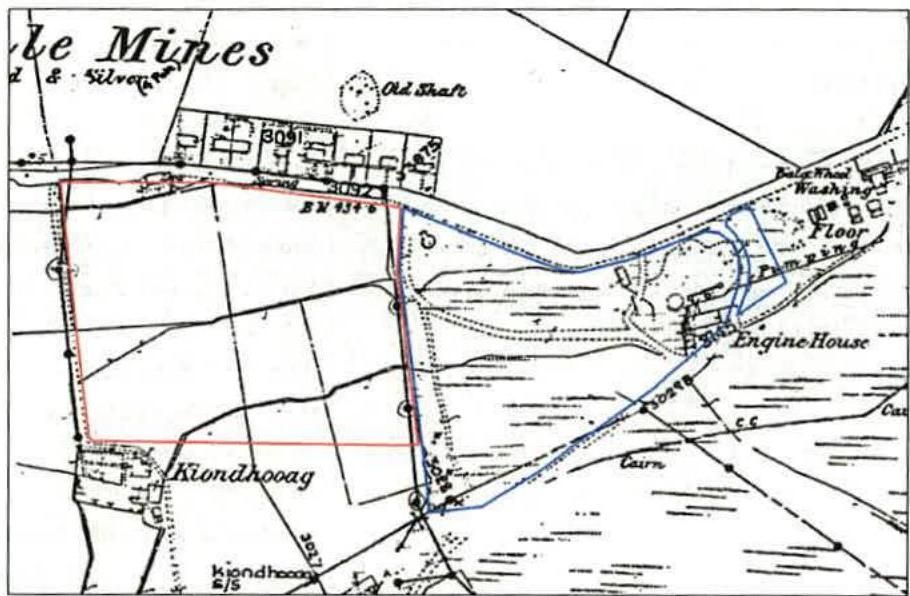
3.1.2. The eastern part of the site has been occupied by the lower, western section of the Upper Foxdale or Louisa Mine. The mine was principally engaged in the underground working of the Foxdale Main Lode, a lead vein sub-cropping to the north of the site. A former engine house
and shaft, probably that known as Pott's Shaft, were located in the eastern part of the site, with the capped shaft now surrounded by a raised mound close to the road junction. The former Engine House was located to the south of the shaft and the above ground remains have been removed.
3.1.3. An undated historical plan, probably from around the early 20th century, reproduced below, shows a number of tracks and a couple of small buildings within the land to the west of the Engine House. Two further shafts (one named as Louisa Shaft) and ore processing areas were located to the east, with processed mine wastes covering the ground up to the side of Stoney Mountain Road. Pumping rods extended from the Engine House eastwards to the upper mine site.
3.1.4. The Foxdale Mines were mainly worked over the period from around 1830 to 1911. More recently, the waste tips were re-worked to recover metals, and have been extensively modified by the removal of gravel and rock for construction purposes. There is continuing erosion of the fine-grained wastes as a result of weather, water flows, and disturbance due to vehicles. There are now few surface remains still evident.
3.1.5. Further old mine workings and surface spoil tips lie 50m or more to the west of the site alongside the Struan Barrule watercourse.
3.2. Topography and Vegetation
3.2.1. The site is located on the southern flank of a small east-west valley, which joins the main north-south Struan Barrule valley just to the west. Site levels vary from about 130m and in the northwest, to over 140m at the mound associated with Pott's Shaft, although a detailed topographical survey is not available.
3.2.2. The fields to the west are unimproved pasture, enclosed by high hedgebanks. Current Government mapping identifies the various parts of the site as follows:
3.2.3. The open land to the east (parcel 333144) is generally covered by rough grass, heath, gorse and scrub woodland except where bare soils are present in the easternmost parts, associated with mine wastes. The minewastes are devoid of vegetation due to one or more factors including low fertility, high plant toxicity (principally due to zinc) or erosion and disturbance.
3.2.4. The open sections of stream channel to the west of the mine run through some bare areas of mining wastes deposited along the banks; these possibly result from previous erosion of the mine tips upstream during storms.
3.2.5. Principal features and field numbers are shown on drawing D02.
3.3. Structures and Services
3.3.1. Features within the site include a disused shed midway along the northern side of the site adjacent to East Foxdale Road, the capped Pott's Shaft, a pair of concrete walls, and stream culvert.
3.3.2. No information is available on services, however it appears unlikely that there are underground services within the site.
3.4. Geology and Soils
3.4.1. The mapped geology from British Geological Survey (BGS) sources shows the site to be underlain by glacial till deposits (mixed clay, silt, sand, gravel and boulders) of undetermined thickness. Bedrock is recorded as the Maughold Formation of Ordovician age (mudstones and siltstones of the Manx Slates) and this outcrops just to the southwest of the site. Given the proximity to the rock outcrop, it may be that weathered mudstones will be present at shallow depth below part or all of the proposed residential development area.
3.4.2. During previous site investigations, an organic turf layer, with a wet peat or peaty clay subsoil, was described within the open land outside the areas of mine deposits, overlying a stony clay subsoil. Within the enclosed fields to the west, the soils were described as stiff brown clay.
3.4.3. The RPS 1989 report described the mine wastes as grey sands and gravels, generally varying in thickness between 0.5 and 2.0m, resting upon the original ground surface. The Pott's Shaft mound was estimated to be about 4m in height, with boiler ash present on the north side, towards the stream. No site investigation logs or soil depth profiles are available.
3.5. Mining
3.5.1. The presence of at least one mine shaft within the site indicates that there are potential hazards from ground instability. The Wardell Armstrong 2008 report concluded that apart from this shaft, all shallow mineworkings are likely to be found associated with the near-surface line of the Main Lode, which is reckoned to lie at least 30m north of the site. However the Lode is believed to have been represented by a number of sub-parallel fractures and mineralisation up to 10m in width. The positions of the Louisa Mine shafts are off-set to the south of the Lode sub-crop; the shafts would probably have intercepted the Main Lode or a branch of the vein at depth, meaning that the vein was inclined to the south, and would therefore underlie at least the northern part of the site. Wardell Armstrong assumed, for risk assessment purposes, that the vein is inclined 65° from horizontal.
3.5.2. They concluded that there was a medium risk from collapse in shallow unrecorded mineworkings in the Main Lode, up to 50m in depth, that might potentially affect a strip along the northern boundary of the proposed development site, extending 130 east-west and 7m wide.
3.5.3. In view of the general mining history and possibility of other unrecorded workings, they also concluded that there was a low risk of other unrecorded mine entries, shallow crop workings, structures and shallow voids throughout the proposed development area.
3.6. Hydrology / Hydrogeology
3.6.1. The principal hydrological feature is a small unnamed stream that runs from east to west along the northern side of the site, parallel to East Foxdale Road, and which collects drainage from the site and land to the south.
3.6.2. The site lies within a region of high rainfall, above low permeability soils and bedrock. It follows that most drainage flows at or close to the ground surface, although some springs are noted to emerge from the base of the coarse-textured mine wastes. No drainage is evident from the western fields, although field drains could be present.
3.6.3. A ditch is present running north to the stream along the boundary between the western and eastern parts of the site. A further minor watercourse flows from the side of Stoney Mountain Road, below the Engine House and mound area, to re-emerge adjacent to the stream. Another intermittent line of drainage runs through the spoil tips to the east of Stoney Mountain Road, to converge with other flows across the eastern part of the mine which then enter the stream culvert below the road.
3.6.4. Although the Foxdale mines will be flooded, the level of water within the various sections of mine is unknown. If the mines remain hydrologically linked, then it may be expected that mine waters will be discharged from the lowest surface opening or weakness, probably alongside the Struan Barrule down-stream of the site. However there is anecdotal information that a spring emerging from the mine wastes to the east of the subject site has its source from the nearby Louisa Shaft. Pott's Shaft is not believed to be flooded to surface, and there is no indication of mine water discharging from this shaft.
3.7. Contamination
3.7.1. The Wolverhampton Polytechnic report provided a systematic assessment of likely contaminated zones across Foxdale, including the fields forming the western part of the site, and the Louisa Mine itself. The report made reference to an earlier chemical survey from 1986 by Richards, Moorehead and Laing for the Chief Environmental Health Inspector. The 1986 report has not been seen, however Wolverhampton Polytechnic categorised the various parcels of land according to assessments of pollution levels (based on heavy metal contamination). Assessments were also made of the conservation value and restoration problems. These were graded from 0 to 4 according to the scale of constraint.
3.7.2. The westernmost field of the residential development site, referred to as no. 3500, had one sample taken, which was found to have slight to zero concentrations of heavy metals. The field was scored P1, C2, R1 ("slight possibility of elevated heavy metal concentration or other geochemical / soil / water factors above background levels", "moderate conservation value", "minor problems / costs would be involved for certain end-uses").
3.7.3. The remainder of the site extending east from field 3500 was classified within the Louisa Mine area but was sub-divided into sections west of Stoney Mountain Road, a Central Area (including the part of the site east of Stoney Mountain Road), and the more distant raised eastern area of the mine. The western sub-section, including the remaining fields was described as open land in the survey, generally covered by heathland and gorse, with bare areas of minewaste at the eastern end, adjacent to the Engine House and extending as a strip alongside the stream. It would appear that the field to the east of field 3500 (now designated field 335000) was enclosed at the time of the Wolverhampton study, and it may be that the field boundary was mistaken for that of field 3500, leading to the inclusion in the
Wolverhampton Polytechnic report of this area within the open land of the Louisa Mine site. The scores given were P4, C2, R4 for the eastern corner and northern margin of the area, and P1, C3, R2 for the remainder. P4 and R4 denote extreme levels of heavy metal contamination and environmental or public health impacts necessitating restoration, together with serious problems and potentially high costs. It is noted that the mine shaft adjacent to the Engine House was not mentioned in the report.
3.7.4. Regarding the remainder of the site, Wolverhampton Polytechnic concluded that metal concentrations were mostly low although a few scattered high levels of lead had been detected (the map shows tracks across parcel 333144, suggesting that these might have utilised hardcore obtained from the mine dumps). The area was considered to have a raised conservation value due to the semi-natural flora and archaeological interest of the extant Engine House. It is noted above that the western side of the areas designated as Louisa Mine was in fact the enclosed pasture of field 335000. Since the date of the report, the Engine House has been demolished and masonry removed.
3.7.5. More recent contamination surveys have been undertaken by RPS in 1989, and Smith Grant in 1994. The former survey included the Louisa Mine area extending up to the edge of the enclosed fields and currently proposed residential development area. The latter survey included the current proposed residential development area and fields to the south, and the land extending east up to Stoney Mountain Road. In both cases, shallow soil samples were collected and analysed for cadmium, lead and zinc concentrations. The sampling methodology and results are reviewed in more detail in section 4.
3.8. Preliminary Conceptual Site Model
3.8.1. The Conceptual Site Model provides a description of the potentially significant contamination sources, and existing or future (under proposed changes to land-use) sensitive receptors. The potential pollution linkages between these sources and receptors are described, as the aim of remediation is to break or reduce to insignificant levels all such linkages.
3.8.2. The most sensitive receptor to potentially toxic concentrations of lead and cadmium is man, with small children being deemed to be especially vulnerable. Consequently, the most sensitive land-use is residential housing where children will play in private garden areas and may be exposed to contamination in soils and dust via ingestion, and to metals via the consumption of vegetables grown in contaminated soils. Less intensive human uses of the land, such as for informal recreation, typically result in lower exposure levels to contaminants, and consequently have reduced risks and reduced sensitivity. Any remediation works may also result in temporary exposure of the site workforce to elevated metals via dust and dirt; such exposures are rarely significant and can be controlled by dust suppression and use of appropriate personal protection and workplace hygiene measures.
Copyright in submitted documents remains with their authors. Request removal
View as Markdown