Loading document...
25/90339
Sarah Corlett Town Planning Consultancy Ltd Registered address: Ballachrink Croft, Ballacorey Road, Bride, Isle of Man IM7 4AW t: 07624 485517 e: [email protected] w: www.sarahcorlett.com Directors: Sarah Elizabeth Corlett, Nicola Jane Corlett Company Registration 134325C
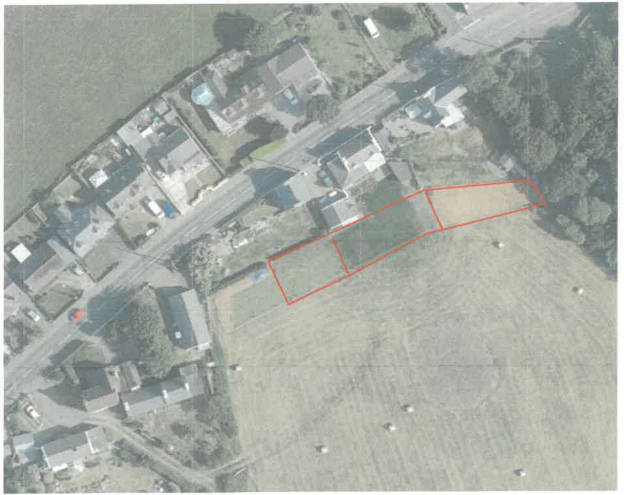
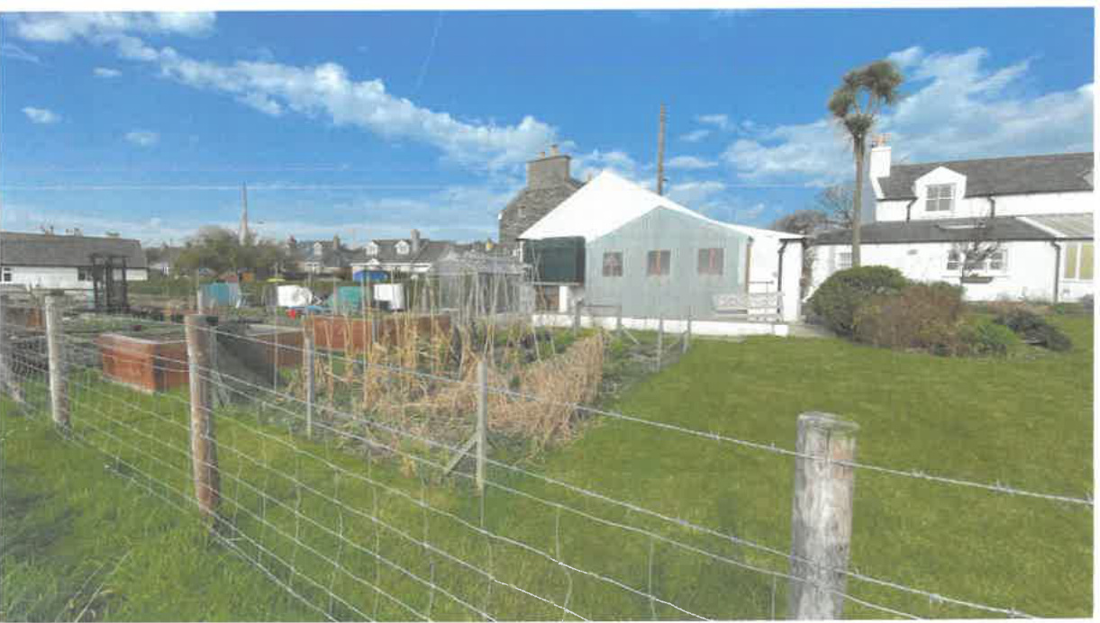
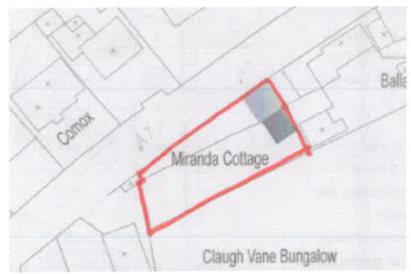
1.1 The site is a parcel of land which sits immediately to the rear of three existing dwellings which front onto Main Road (A7) in Colby. These properties are, west to east, Miranda Cottage, Ballavere Cottage and Brook Cottage. 1.2 These properties are some of the relatively few properties which are on the southern side of the A7 between Colby village and The Level. To the east of Brook Cottage is a small arboretum and to the south west of Miranda Cottage is Claugh Vane Bungalow. 1.3 The application properties are traditional Manx cottages: Miranda Cottage is smaller than the other two and has a recently added small front porch and other approved extensions (see Planning History) but has otherwise not been extended whereas Brook Cottage and Ballavere Cottage both have later extensions. 1.4 Brook Cottage and Miranda Cottage sit with their gables to the highway and Ballavere Cottage has its principal elevation facing the road.
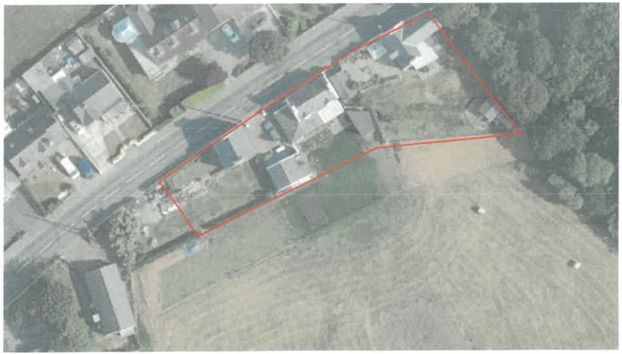
1.5 The lawful residential curtilages of Miranda and Ballavere Cottages are continuous in terms of the rear boundary with the adjacent agricultural field and have a depth of between 14m and 19m from the highway. The rear boundary of Brook Cottage is set at an angle and varies between 19m alongside Ballavere Cottage and 27m alongside the arboretum.
1.6 Ballavere Cottage has a detached garage which sits on this rear boundary with the field.
1.7 The applicants all purchased a section of the adjacent field to the south and were unaware that planning approval was required to extend their gardens into this agricultural land. One property is in the process of being sold and the breach of planning control was only highlighted to them as part of this process.
1.8 The area which is the subject of this application effectively extends the residential curtilages by approximately 11m into the agricultural field to the south with the extension of the curtilage of Brook Cottage tapering to 5m at the eastern side of the site.
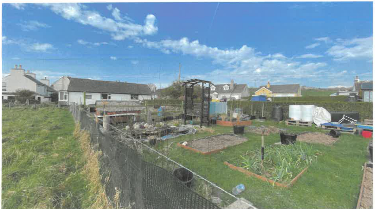
1.9 All three properties have extended their gardens into this adjacent area. Miranda Cottage is partly using the area for the growing of vegetables and fruit (so arguably there has been no change of use) but the owners would wish for this area to be lawfully incorporated into
Sarah Corlett Town Planning Consultancy Ltd Registered address: Ballachrink Croft, Ballacorey Road, Bride, Isle of Man IM7 4AW t: 07624 485517 e: [email protected] w: www.sarahcorlett.com Directors: Sarah Elizabeth Corlett, Nicola Jane Corlett Comsum Registration 134325C
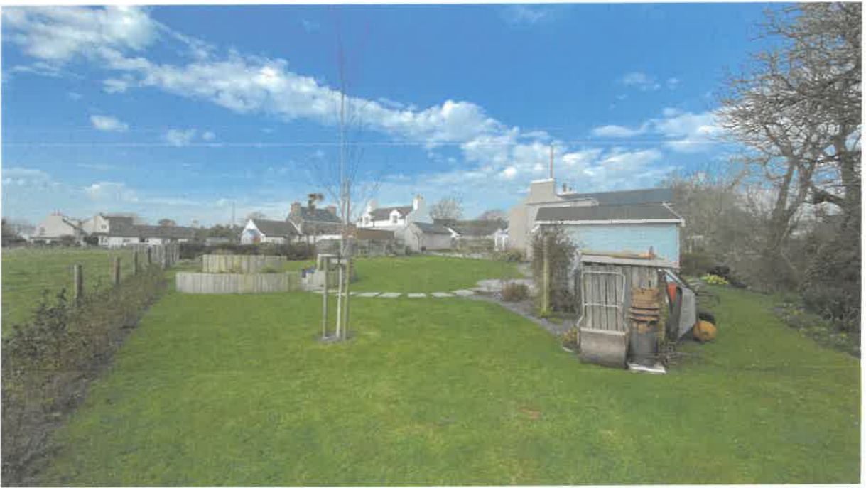
the residential curtilage. Brook Cottage has this extended area laid to lawn with flower beds and a seating area. Ballavere Cottage has the rear garden laid to lawn with a raised planter and flower beds.
Above: extended rear garden of Brook Cottage Below: extended rear garden of Ballavere Cottage
Sarah Corlett Town Planning Consultancy Ltd Registered address: Ballachrink Croft, Ballacorey Road, Bride, Isle of Man IM7 4AW t: 07624 485517 e: [email protected] w: www.sarahcorlett.com Directors: Sarah Elizabeth Corlett, Nicola Jane Corlett
Above: extended rear gardens of Ballavere Cottage and Miranda Cottage used for vegetable and fruit planting Above: extended rear garden of Miranda Cottage used for fruit and vegetable growing
Sarah Corlett Town Planning Consultancy Ltd Registered address: Ballachrink Croft, Ballacorey Road, Bride, Isle of Man IM7 4AW t: 07624 485517 e: [email protected] w: www.sarahcorlett.com Directors: Sarah Elizabeth Corlett, Nicola Jane Corlett Commonsy Registration 134325C
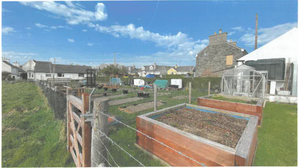
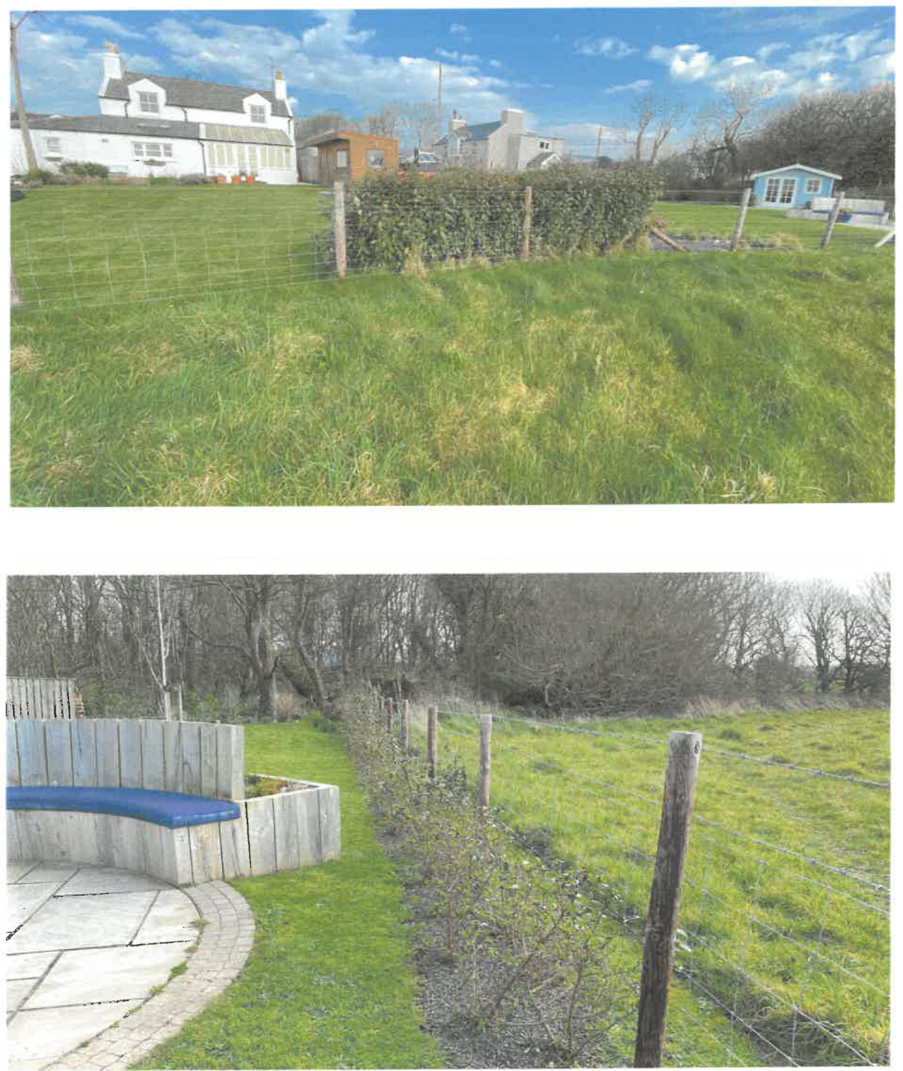
1.10 The rear boundary with the field is formed by a post and wire fence, as requested by the owner of the adjacent field, with some hedge planting having been introduced to the rear of Ballavere Cottage and Brook Cottage.
Sarah Corlett Town Planning Consultancy Ltd 6 Registered address: Ballachrink Croft, Ballacorey Road, Bride, Isle of Man IM7 4AW t: 07624485517 e: [email protected] w: www.sarahcorlett.com Directors: Sarah Elizabeth Corlett Nicola Jane Corlett Company Registration 134325C
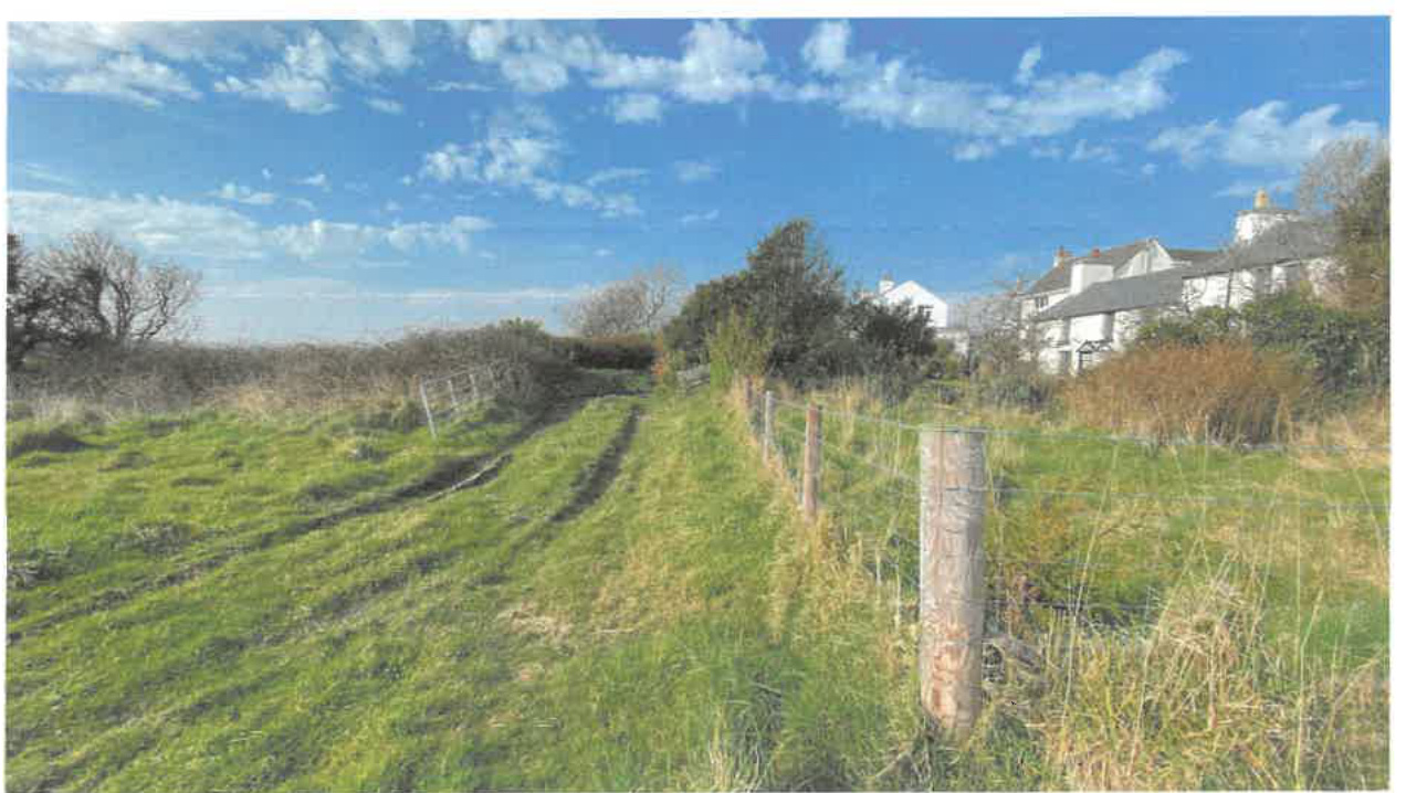
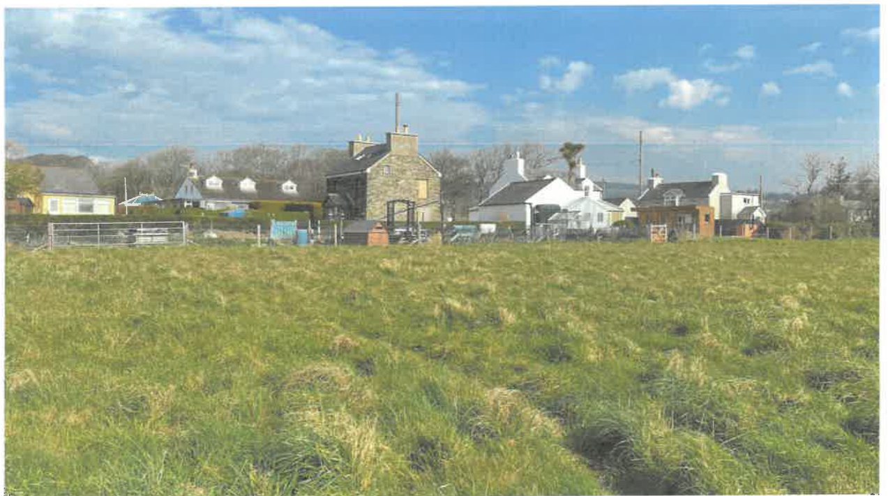
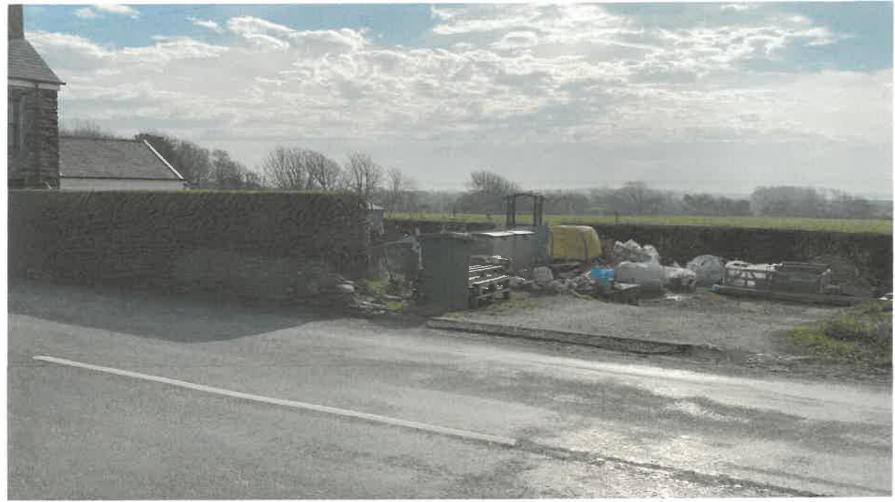
1.11 The field into which the gardens have been extended is presently not actively used but has most recently been used for seasonal grazing, leased to a farmer who uses it to complement his holding. The ground is uneven and unmanaged:
1.12 Access into it is from a lane to the west:
[^0] [^0]: Sarah Corlett Town Planning Consultancy Ltd 7 Registered address: Ballachrink Croft, Ballacorey Road, Bride, Isle of Man IM7 4AW t: 07624485517 e: [email protected] w: www.sarahcorlett.com Directors: Sarah Elizabeth Corlett Nicola Jane Corlett Company Registration 134325C
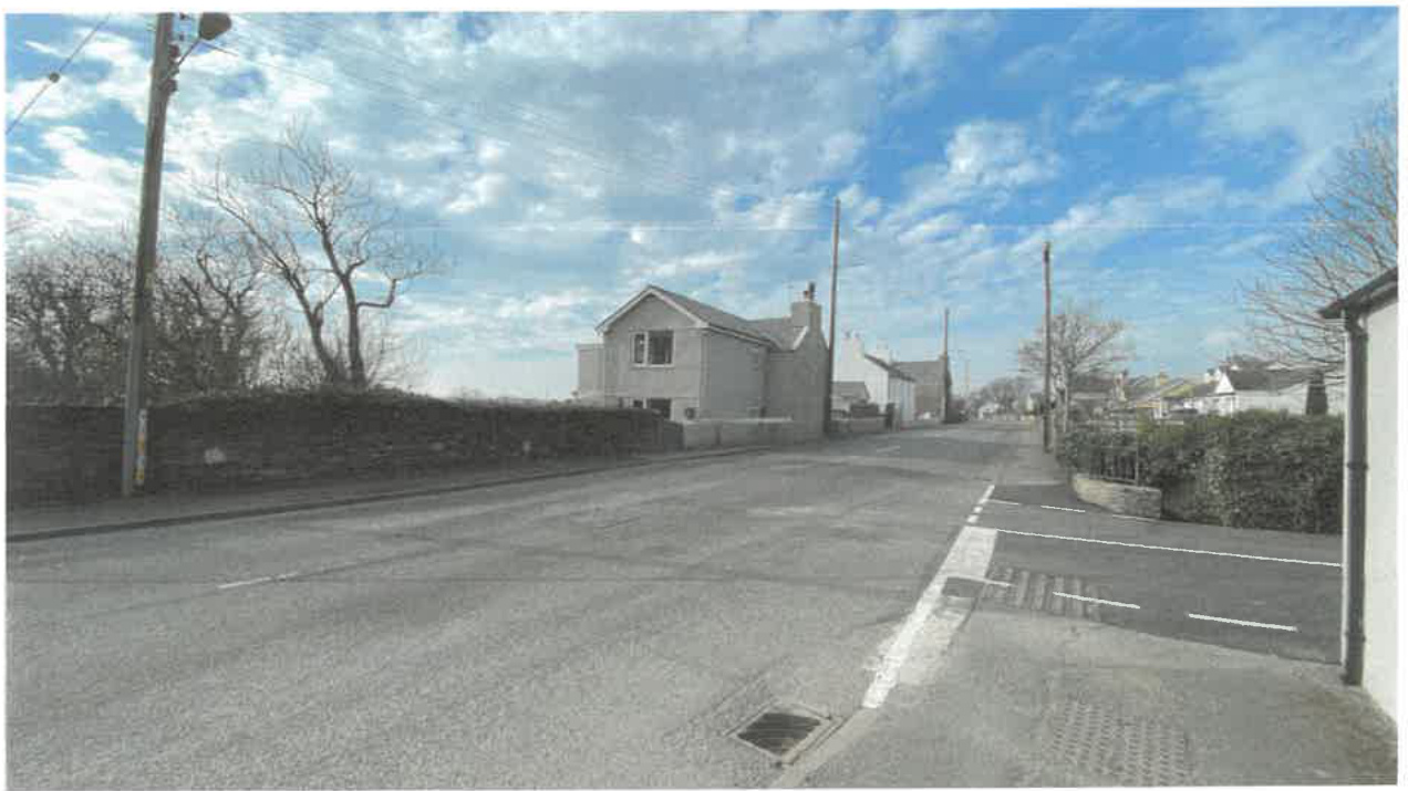
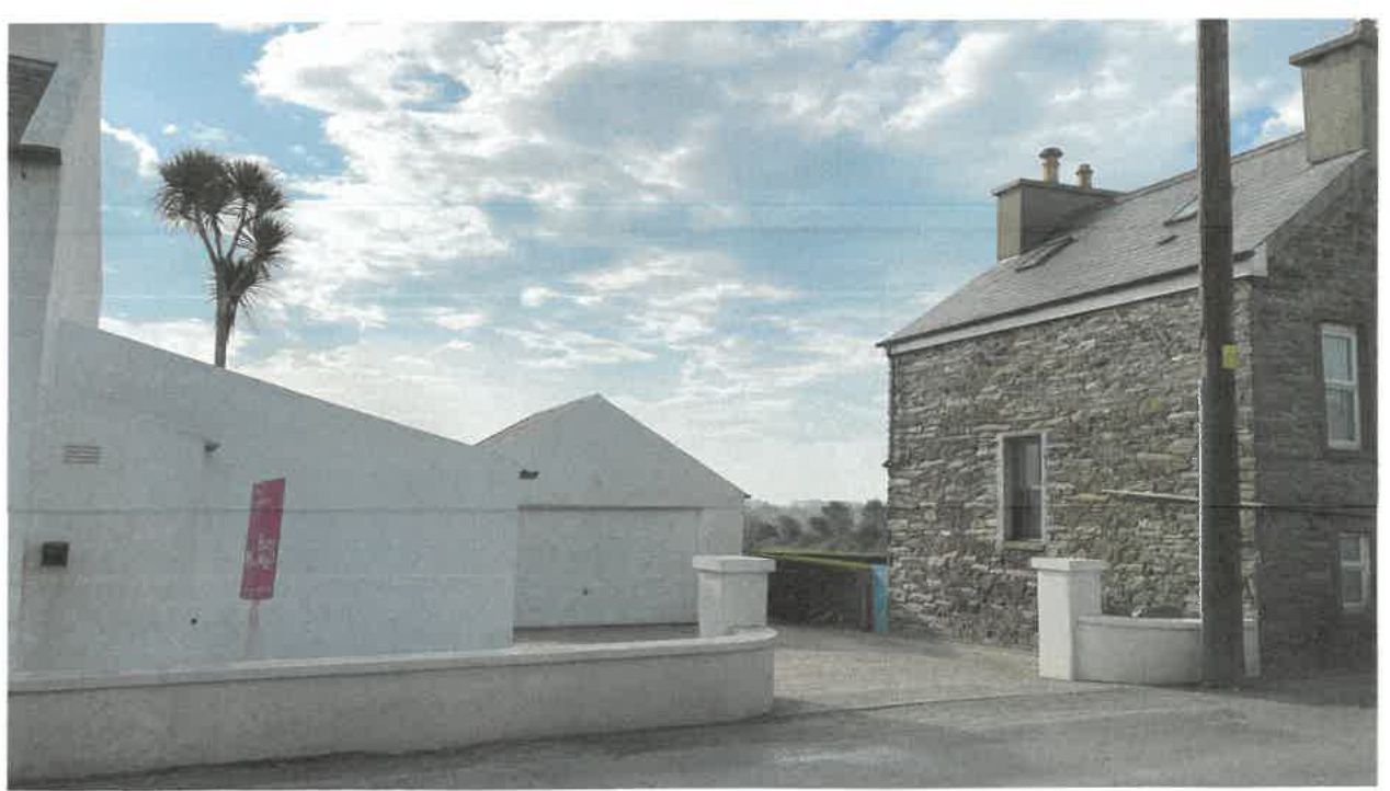
1.13 The field and extended gardens are not visible from the main road as it is screened by the existing buildings and walling:
Approach to Brook Cottage from the east
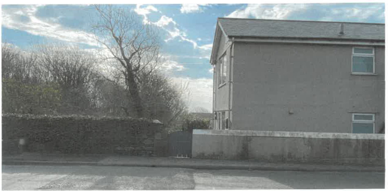
View past the eastern gable of Brook Cottage towards the field
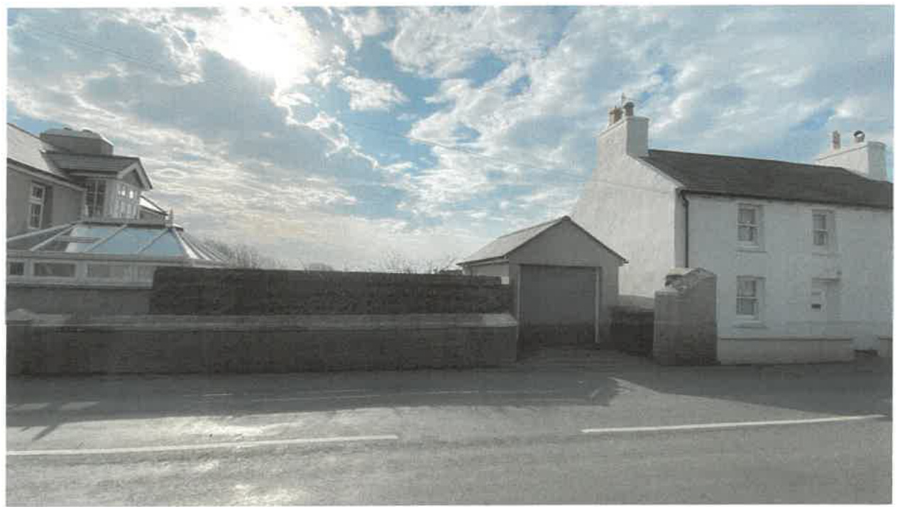
Views between Ballavere Cottage and Miranda Cottage
Sarah Corlett Town Planning Consultancy Ltd Registered address: Ballachrink Croft, Ballacorey Road, Bride, Isle of Man IM7 4AW t: 07624 485517 e: [email protected] w: www.sarahcorlett.com Directors: Sarah Elizabeth Corlett, Nicola Jane Corlett Company Registration 134325C
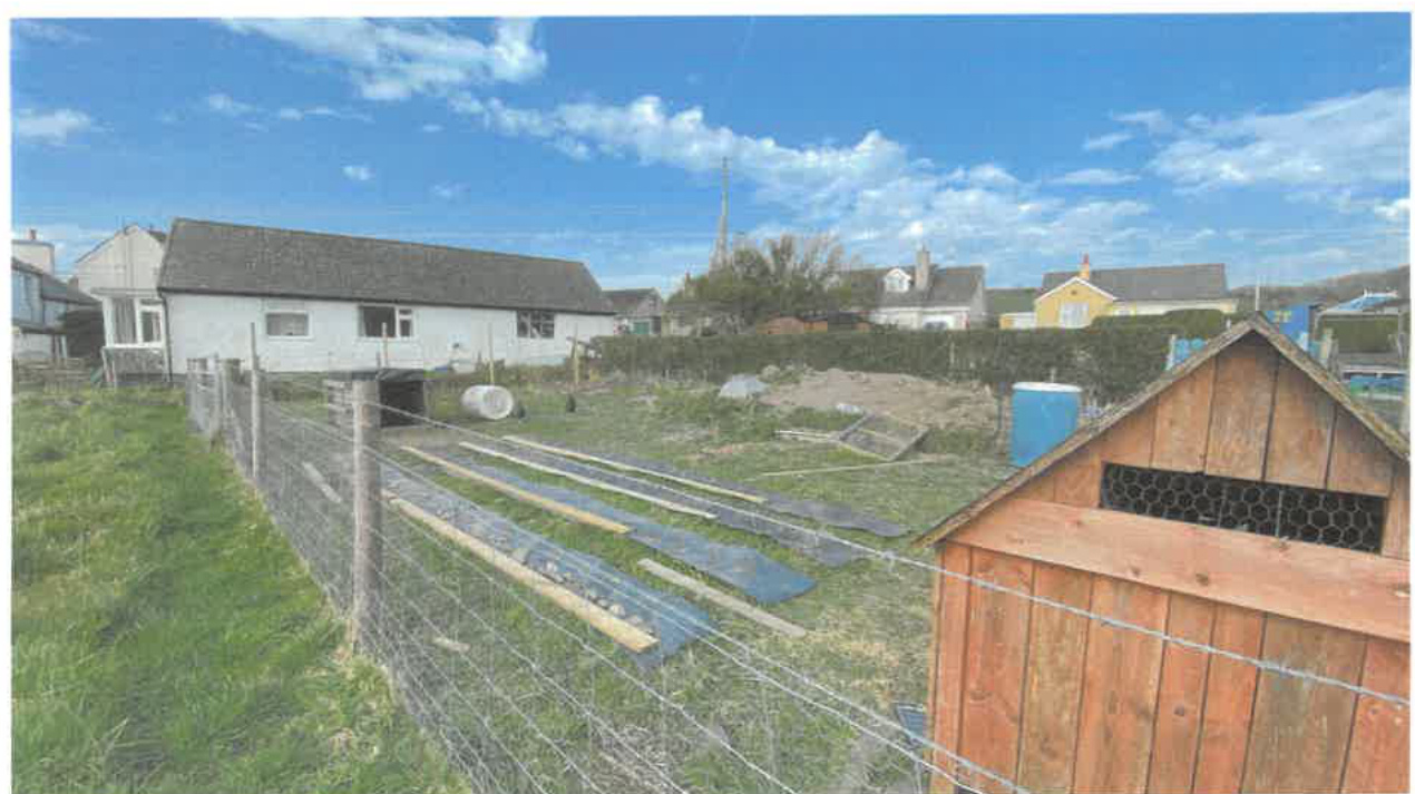
Above: view from the west of Miranda Cottage. This area used for storage and with an access from the road is owned separate from Miranda Cottage).
Below: the rear of this area is used by chickens:
Sarah Corlett Town Planning Consultancy Ltd Registered address: Ballachrink Croft, Ballacorey Road, Bride, Isle of Man IM7 4AW t: 07624485517 e: [email protected] w: www.sarahcorlett.com Directors: Sarah Elizabeth Corlett Nicola Jane Corlett Company Registration 134325C
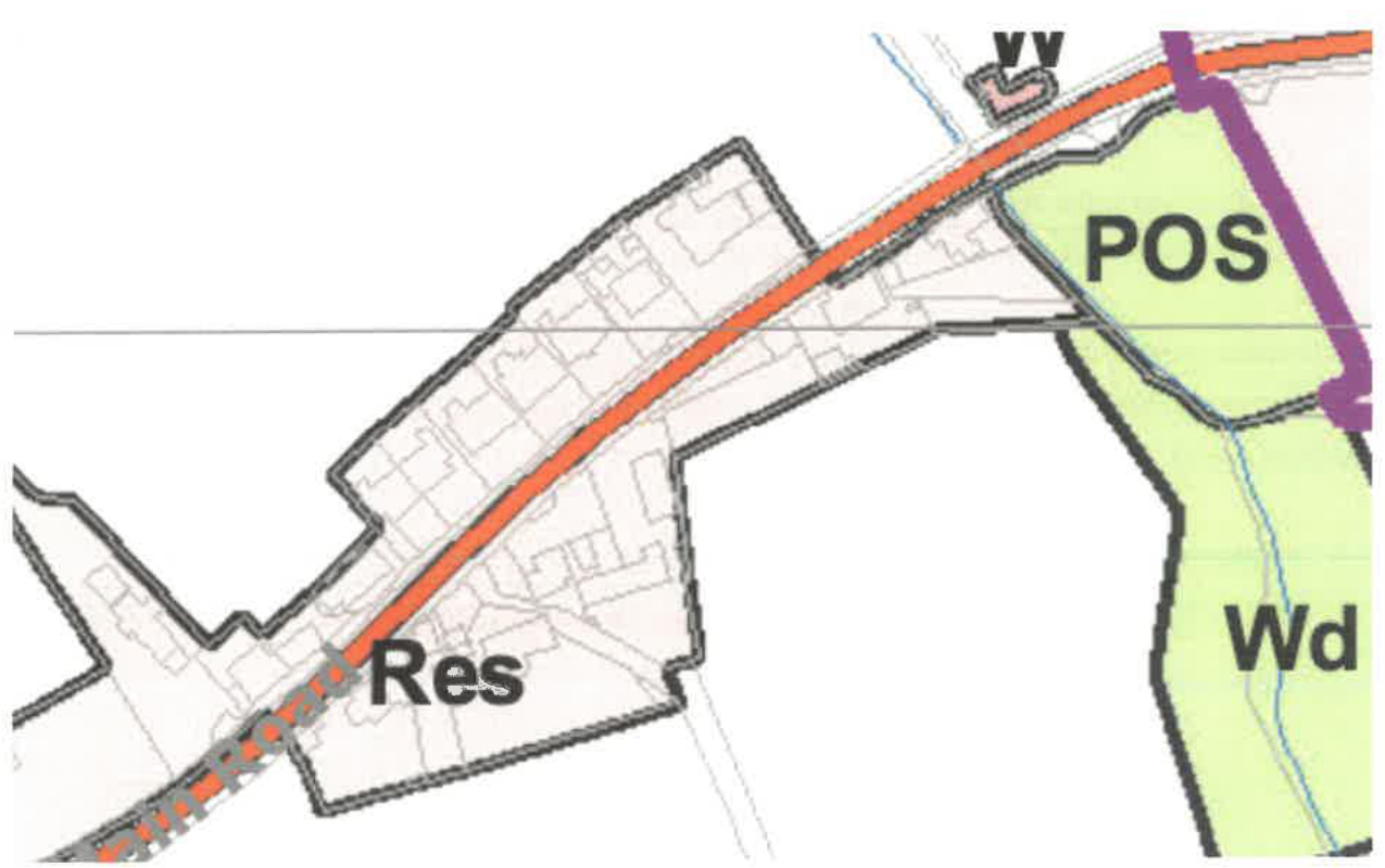
2.1 The site lies within an area designated on the Area Plan for the South which was adopted in 2013, as not for a particular purpose. In this respect, the land is considered to be countryside as defined in Environment Policy 1 of the Strategic Plan. The rear boundaries of these three dwellings is shown as they originally appeared. The purple line on the plan below shows the western extent of the settlement boundary of Colby: the properties are outwith the settlement boundary.
Excerpt from the Area Plan for the South: Map 6 2.2 There are no Constraints shown on the relevant map accompanying the Area Plan and there are no Environmental Constraints (wildlife areas, ASSIs, Conservation Areas or Registered Buildings) shown on the Government maps other than a line of Registered Trees which sit either side of the stream which runs south from Scholaby to the Colby River, on the eastern boundary of Brook Cottage.
2.3 The site is not shown as being at risk of flooding on the national flood risk maps other than a small section at the east of Brook Cottage, associated with the adjacent stream.
2.4 Land which is not designated for development is considered to be countryside and where development which is harmful to it is presumed against and the landscape is generally protected (Environment Policy 1, Strategic Policies 3 and 4 and Environment Policy 42). 2.5 General Policy 3 sets out a number of exceptions to this although the extension of residential curtilages is not one. 2.6 The most versatile agricultural soils are protected from development (Environment Policy 14). The soil here is $3 / 2$ and therefore falls within this category. 2.7 Development which would adversely affect trees of amenity value is presumed against (Environment Policy 3) as is development which would be harmful to ecology (Environment Policies 4 and 7). 2.8 Development is generally directed towards existing settlements and sustainable locations (Strategic Policies 1, 2 and 10, Spatial Policy 5, Housing Policy 4 and Transport Policy 1).
3.1 The sites have been the subject of previous applications as follows:
3.1.1 Only one application has been submitted for this property.
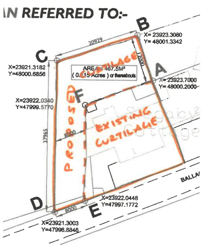
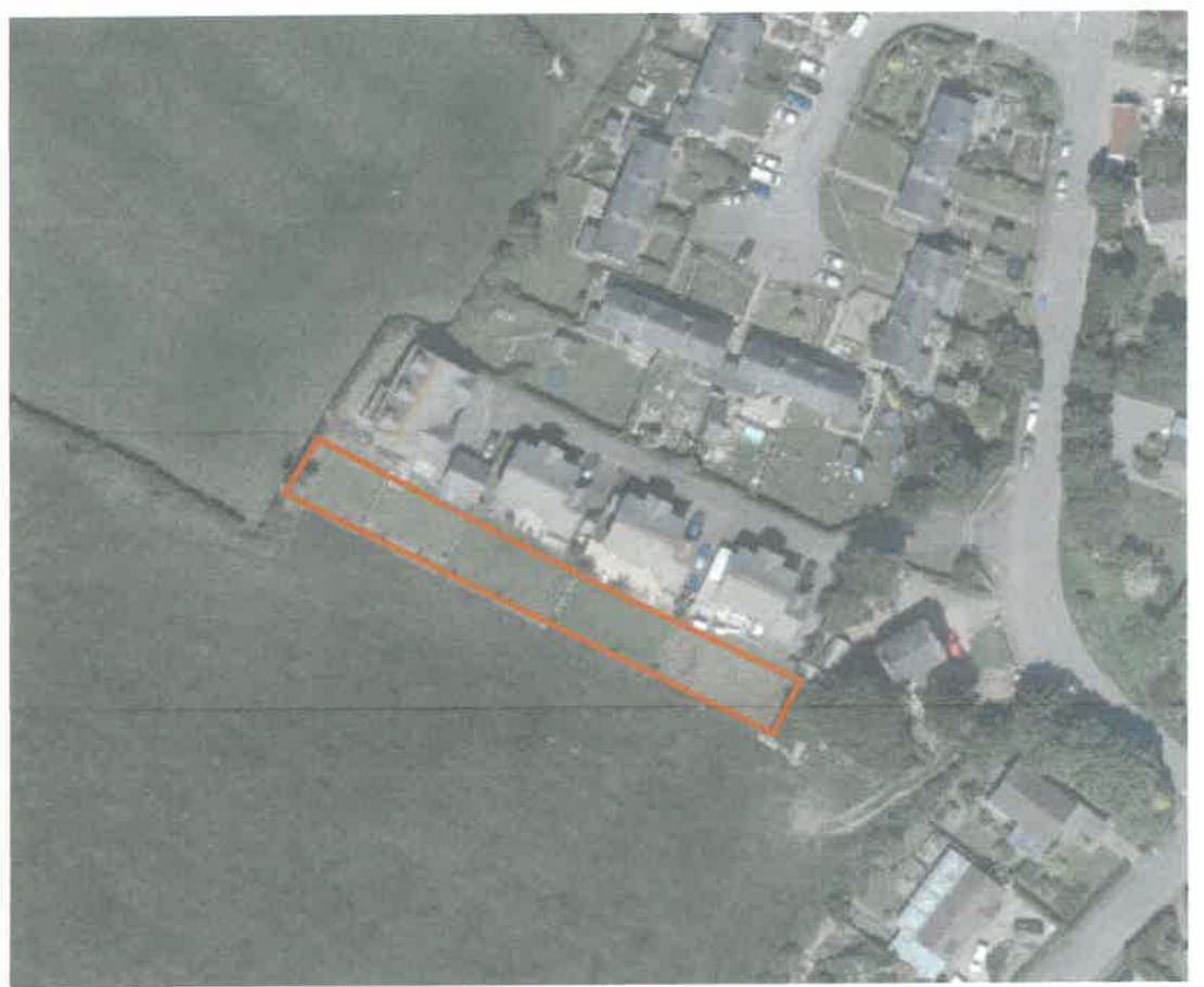
Planning approval was granted for the erection of a porch and two storey extension (20/00946/B). This shows the residential curtilage as follows although this has since been divided and the south westernmost section is now in separate ownership and used for agricultural purposes (see page 10 ):
3.2.1 This has been the subject of two applications. Permission was granted for the demolition of the existing extension and erection of new extension on the rear ( $95 / 01126 / \mathrm{B}$ ).
Permission was then sought and granted for alterations and an extension to the dwelling with a garage and driveway and new vehicular access ( $97 / 01866 / B$ ).
3.3.1 This property too has been the subject of two previous applications: erection of a conservatory to replace existing extension ( $14 / 00936 / B$ ) and for the installation of replacement windows ( $10 / 00310 / B)$. Both were approved.
3.4.1 There have been a number of applications for the extension of a property's residential curtilage which are worthy of note. i. 13/00151/C proposed the change of use of agricultural land at the rear of 1 , Slegaby Cottages in Onchan: ii. This involved the extension of the residential curtilage 12 m to the rear and 8 m to the side of the existing dwelling and was refused by the Planning Committee. The inspector comments as follows: "10. General Policy 3 and Environment Policy 1 have important aims to safeguard the Manx countryside from unwarranted development and encroachment. In this particular case, however, the dwelling has practically no residential curtilage to the side or rear, where the
boundaries hug close to the building, and only a very small front garden...It would not be going too far to say that the lack of amenity space makes it deficient by present day standards. The additional residential curtilage being sought is not excessive or more than might reasonably be expected to serve this home.
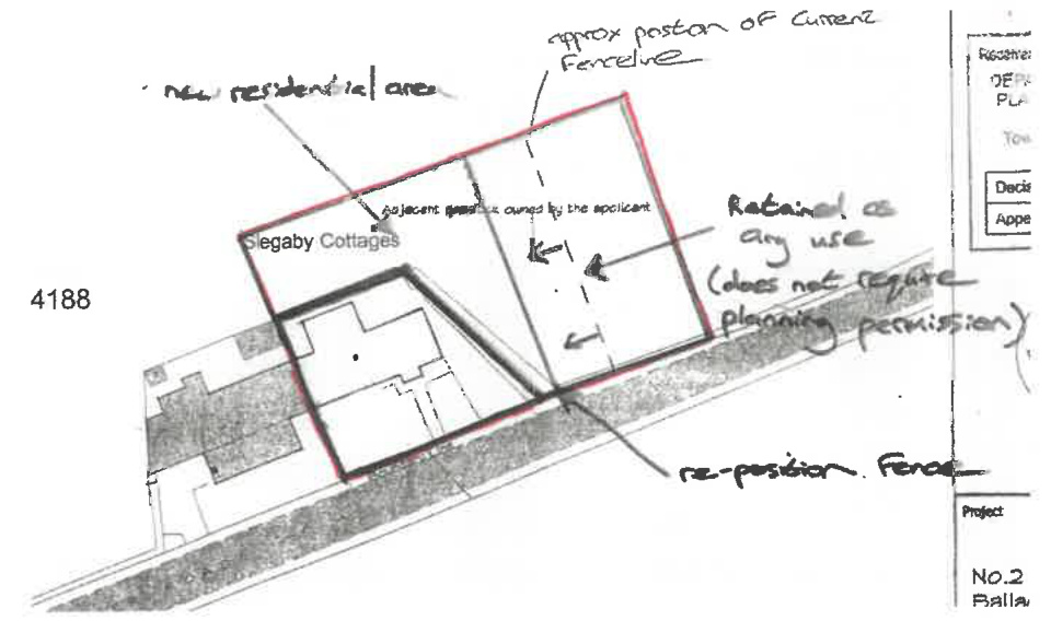
Environment Policy 1. There would be a small loss of agricultural land, undesirable but very limited in extent, and my conclusion does depend on the added land being used only for garden purposes without ancillary structures." iii. 13/00019/C proposed the change of use of the neighbouring property to the one above and the inspector reached the same conclusion, reiterating paragraph 11 above for this application also.
iv. 12/00999/C proposed the extension of the residential curtilage of Curlew Cottage in Castletown. This application was refused by the Planning Committee and approved at appeal, the inspector noting the following:
"11. In relation to the countryside and landscape policies, the proposal lies outside of any settlement and is not designated for development which includes extending a residential curtilage into agricultural land. In principle, therefore, the proposal is contrary to Policy EP1 which seeks to protect the countryside and its ecology for its own sake However, the polices also seeks to ensure that development would not have any adverse visual effect and the proposal should be assessed on this basis as well as on the basis of the principle of development.
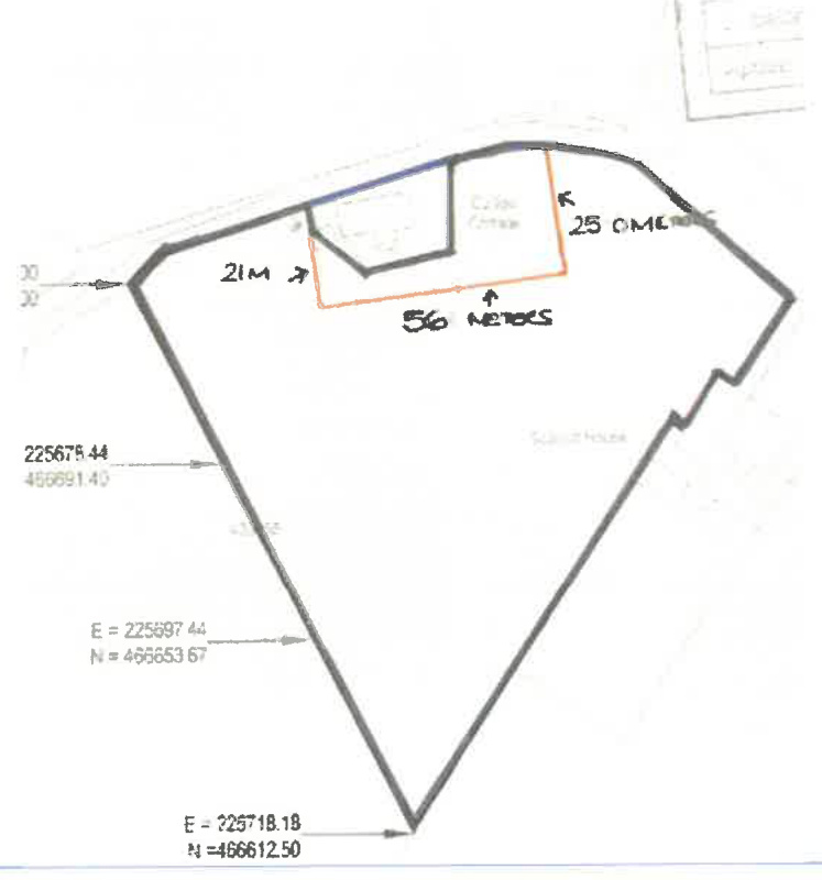
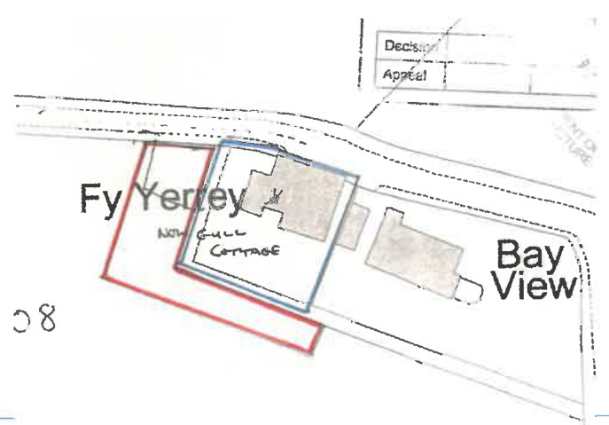
v. 14/00535/C proposed the extension of the domestic curtilage at Gull Cottage in Baldrine where the Planning Committee visited the site and approved the extension of his residential curtilage as shown right:
vii. The most recent application which is of relevance is $23 / 00884 / \mathrm{C}$ which was approved on appeal for land at Andreas. The inspector makes the following concluding comments: "89. Limited harm has been identified to the character of the countryside as well as harm by reason of an at face value conflict with IMSP Policies EP1, GP2 and GP3. However, I have ascribed considerable weight to the benefit of the scheme in the provision of garden space of an adequate standard to appropriately serve 4 - bedroom family homes. This would be in the interests of the health and wellbeing of residents. Also weighing in the positive side of the balance in favour of the proposal, is the permission granted at a neighbouring site, Thie Cheerey where circumstances are very similar to that of this appeal.
3.5.1 The former/lawful residential curtilages were not inadequate in themselves but were much smaller than all of the residential curtilages adjacent and opposite. What is proposed therefore is not out of keeping or out of proportion compared with the surrounding area. 3.5.2 The extension of the curtilages will not afford the users of these new gardens any significant or harmful view or outlook towards existing residential properties and there will be no harm to existing residential amenity as a result. Each of the adjacent properties will have their residential curtilage extended by the same amount.
3.6.1 The countryside policies are not only concerned with the visual impact of development, including changes of use, but also the loss of high quality agricultural land. In this case, the field appears to be Class $3 / 2$ which would result in it generally being protected from development under Environment Policy 14. 3.6.2 The field of which these extended gardens was once part is not actively used for agricultural purposes and those areas within the extended gardens which are being used for growing fruit and vegetables have raised beds and planters and with those areas where soil or compost has not been imported, the ground does not appear particularly good growing soil. 3.6.3 In any case, the amount of land being "lost" from agricultural production is slight around 670 sq m which is not considered significant enough to merit concern for the loss of opportunities for agricultural productivity.
4.1 The extension of the residential curtilages of these three properties would have no visual impact on the character or appearance of the countryside and therefore there would be no harm to the countryside. The proposal is therefore not considered to be in breach of Environment Policy 1 as stated in the reason for refusal. 4.2 Whilst the site is not designated for development, there would be no harm to the character of the countryside from the proposed development, and the extension of the curtilages of these residential properties would enable each dwelling to have private amenity space which is recognised in the Strategic Plan as an important element of residential development: "Applicants are asked to note that all new residential development must provide adequate standards of residential amenity, including private open space such as gardens or shared amenity spaces for apartments, and bin storage areas. Meeting the open space requirement in this Appendix does not exempt applicants from providing adequate private open space." (Appendix 7 paragraph A.6.1.1). 4.3 The importance of adequate private amenity space has been highlighted in the recent COVID lock down periods and made people more appreciative of the need for a pleasant place to relax, play and even plant flowers, fruit and vegetables which could enhance the biodiversity value of this part of the field, compared with if it were ploughed or grazed. 4.4 In fact, the gardens which have emerged since the incorporation of this land into the curtilages of the adjacent residential properties accommodate fruit trees, plants, flowers and vegetables all of which add more to the biodiversity of the area than does the grassed field. 4.5 Each case for extension of residential curtilages into undesignated land needs to be taken on its own merits and it is clear from the examples provided above that there can be cases where such proposals can be considered acceptable. In this case, there will be no harmful impact on the countryside, no adverse impact on adjacent residential properties and no significant loss of productive agricultural land as a result of the extension of these gardens. As shown, the additional land has enabled each of the property owners to introduce more planting which will enhance biodiversity and maintain an attractive and useful area proportionate and appropriate to the surrounding area.
25.03.25
Strategic Policy 1: Development should make the best use of resources by: (a) optimising the use of previously developed land, redundant buildings, unused and under-used land and buildings, and reusing scarce indigenous building materials; (b) ensuring efficient use of sites, taking into account the needs for access, landscaping, open space(1) and amenity standards; and (c) being located so as to utilise existing and planned infrastructure, facilities and services.
Strategic Policy 2: New development will be located primarily within our existing towns and villages, or, where appropriate, in sustainable urban extensions(2) of these towns and villages. Development will be permitted in the countryside only in the exceptional circumstances identified in paragraph 6.3.
Strategic Policy 3: Proposals for development must ensure that the individual character of our towns and villages is protected or enhanced by: (a) avoiding coalescence and maintaining adequate physical separation between settlements; and (b) having regard in the design of new development to the use of local materials and character.
Strategic Policy 4: Proposals for development must: (a) Protect or enhance the fabric and setting of Ancient Monuments, Registered Buildings(1), Conservation Areas(2), buildings and structures within National Heritage Areas and sites of archaeological interest; (b) protect or enhance the landscape quality and nature conservation value of urban as well as rural areas but especially in respect to development adjacent to Areas of Special Scientific Interest and other designations; and (c) not cause or lead to unacceptable environmental pollution or disturbance.
Strategic Policy 10: New development should be located and designed such as to promote a more integrated transport network with the aim to: (a) minimise journeys, especially by private car; (b) make best use of public transport; (c) not adversely affect highway safety for all users, and (d) encourage pedestrian movement
Spatial Policy 5: New development will be located within the defined settlements. Development will only be permitted in the countryside in accordance with General Policy 3.
General Policy 2: Development which is in accordance with the land-use zoning and proposals in the appropriate Area Plan and with other policies of this Strategic Plan will normally be permitted, provided that the development: (a) is in accordance with the design brief in the Area Plan where there is such a brief; (b) respects the site and surroundings in terms of the siting, layout, scale, form, design and landscaping of buildings and the spaces around them; (c) does not affect adversely the character of the surrounding landscape or townscape; (d) does not adversely affect the protected wildlife or locally important habitats on the site or adjacent land, including water courses; (e) does not affect adversely public views of the sea; (f) incorporates where possible existing topography and landscape features, particularly trees and sod banks; (g) does not affect adversely the amenity of local residents or the character of the locality;
( $h$ ) provides satisfactory amenity standards in itself, including where appropriate safe and convenient access for all highway users, together with adequate parking, servicing and manoeuvring space; (i) does not have an unacceptable effect on road safety or traffic flows on the local highways; (j) can be provided with all necessary services; (k) does not prejudice the use or development of adjoining land in accordance with the appropriate Area Plan; (1) is not on contaminated land or subject to unreasonable risk of erosion or flooding; (m) takes account of community and personal safety and security in the design of buildings and the spaces around them; and (n) is designed having due regard to best practice in reducing energy consumption.
General Policy 3: Development will not be permitted outside of those areas which are zoned for development on the appropriate Area Plan with the exception of: (a) essential housing for agricultural workers who have to live close to their place of work; (Housing Policies 7, 8, 9 and 10); (b) conversion of redundant rural buildings which are of architectural, historic, or social value and interest; (Housing Policy 11); (c) previously developed land(1) which contains a significant amount of building; where the continued use is redundant; where redevelopment would reduce the impact of the current situation on the landscape or the wider environment; and where the development proposed would result in improvements to the landscape or wider environment; (d) the replacement of existing rural dwellings; (Housing Policies 12, 13 and 14); (e) location-dependent development in connection with the working of minerals or the provision of necessary services;
(1) building and engineering operations which are essential for the conduct of agriculture or forestry; (g) development recognised to be of overriding national need in land use planning terms and for which there is no reasonable and acceptable alternative; and (h) buildings or works required for interpretation of the countryside, its wildlife or heritage.
Environment Policy 1: The countryside and its ecology will be protected for its own sake. For the purposes of this policy, the countryside comprises all land which is outside the settlements defined in Appendix 3 at A.3.6 or which is not designated for future development on an Area Plan. Development which would adversely affect the countryside will not be permitted unless there is an over-riding national need in land use planning terms which outweighs the requirement to protect these areas and for which there is no reasonable and acceptable alternative.
Environment Policy 3: Development will not be permitted where it would result in the unacceptable loss of or damage to woodland areas, especially ancient, natural and seminatural woodlands, which have public amenity or conservation value.
Environment Policy 4: Development will not be permitted which would adversely affect: (a) species and habitats of international importance: (i) protected species of international importance or their habitats; or (ii) proposed or designated Ramsar and Emerald Sites or other internationally important sites. (b) species and habitats of national importance: (i) protected species of national importance or their habitats; Wildlife Sites are defined in Appendix 1
(iii) proposed or designated National Nature Reserves, or Areas of Special Scientific Interest; or (iii) Marine Nature Reserves; or (iv) National Trust Land. (c) species and habitats of local importance such as Wildlife Sites, local nature reserves, priority habitats or species identified in any Manx Biodiversity Action Plan which do not already benefit from statutory protection, Areas of Special Protection and Bird Sanctuaries and landscape features of importance to wild flora and fauna by reason of their continuous nature or function as a corridor between habitats. Some areas to which this policy applies are identified as Areas of Ecological Importance or Interest on extant Local or Area Plans, but others, whose importance was not evident at the time of the adoption of the relevant Local or Area Plan, are not, particularly where that plan has been in place for many years. In these circumstances, the Department will seek site specific advice from the Department of Agriculture, Fisheries and Forestry if development proposals are brought forward.
Environment Policy 7: Development which would cause demonstrable harm to a watercourse, wetland, pond or dub, and which could not be overcome by mitigation measures will not be permitted. Where development is proposed which would affect a watercourse, planning applications must comply with the following criteria: (a) all watercourses in the vicinity of the site must be identified on plans accompanying a planning application and include an adequate risk assessment to demonstrate that works will not cause long term deterioration in water quality; (b) details of pollution and alleviation measures must be submitted; (c) all engineering works proposed must be phased in an appropriate manner in order to avoid a reduction in water quality in any adjacent watercourse; and (d) development will not normally be allowed within 8 metres of any watercourse in order to protect the aquatic and bankside habitats and species.
Environment Policy 14: Development which would result in the permanent loss of important and versatile agricultural land (Classes 1-2) will not be permitted except where there is an overriding need for the development, and land of a lower quality is not available and other policies in this plan are complied with. This policy will be applied to (a) land annotated as Classes $1 / 2$ on the Agricultural Land Use Capability Map; and (b) Class 2 soils falling within areas annotated as Class $2 / 3$ and Class $3 / 2$ on the Agricultural Land Use Capability Map.
Environment Policy 42: New development in existing settlements must be designed to take account of the particular character and identity, in terms of buildings and landscape features of the immediate locality. Inappropriate backland development, and the removal of open or green spaces which contribute to the visual amenity and sense of place of a particular area will not be permitted. Those open or green spaces which are to be preserved will be identified in Area Plans.
Housing Policy 4: New housing will be located primarily within our existing towns and villages, or, where appropriate, in sustainable urban extensions of these towns and villages where identified in adopted Area Plans: otherwise new housing will be permitted in the countryside only in the following exceptional circumstances: (a) essential housing for agricultural workers in accordance with Housing Policies 7, 8, 9 and 10; (b) conversion of redundant rural buildings in accordance with Housing Policy 11; and (c) the replacement of existing rural dwellings and abandoned dwellings in accordance with Housing Policies 12, 13 and 14.
Transport Policy 1: New development should, where possible, be located close to existing public transport facilities and routes, including pedestrian, cycle and rail routes.
- -
Copyright in submitted documents remains with their authors. Request removal
View as Markdown