Planning Statement In Respect Of Alterations And Extensions To Dwelling With An Extension To The Residential Curtilage, Ballavayre Farmhouse, Ballakilpheric, Rushen Im9 4Bx
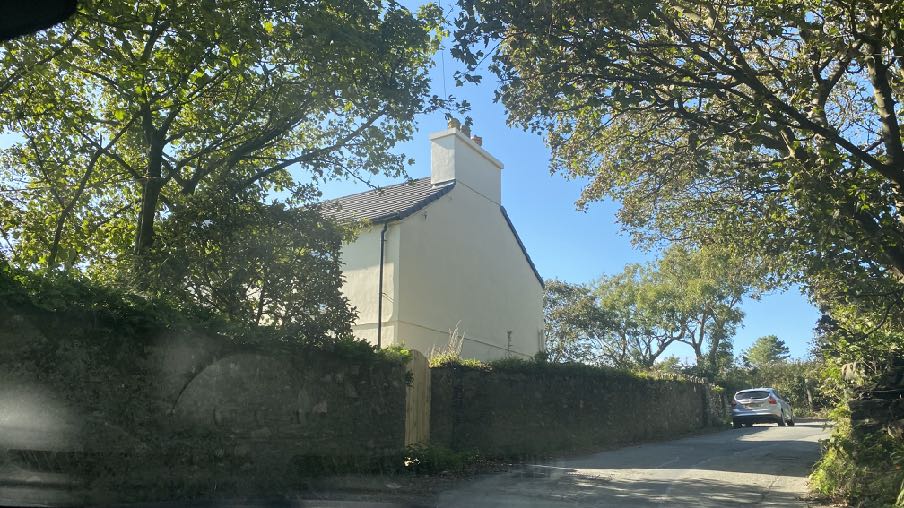
A photograph showing a white detached house viewed through trees, with a stone wall in the foreground and a car parked on the road to the right.
1.0 Introduction
1.1 The site lies to the west of the Ballakilpheric Road (B44) which links Colby to the south with Lingague to the north, passing through small groups of buildings including a chapel, houses and several farms. Ballavayre Cottage lie to the south of the site and Ballacreg lies immediately across the road to the east.
1.2 Ballavayre Farmhouse and Ballacreg are both traditional stone Manx cottages whilst Ballavayre Cottage has an original stone traditional core which sits immediately alongside the road, with a central eaves level peak having been introduced and the property also has a sizeable side extension to the west which is more modern in form and detail, finished in render and with modern proportioned windows and two pitched roofed eaves level dormers in the front elevation. A single storey extension sits alongside this and a flat roofed, single garage is located to the rear of the house.
1.3 Ballavayre Farm is one of the area’s farms with the farm land and remaining stone barns
separated from the farm house in ownership - sitting to the east, alongside the road, and the farm land, lying to the north, west and south of the farm house.
1.4 There is pedestrian access into the site from the public highway with a further access to the farm building and land slightly further north.
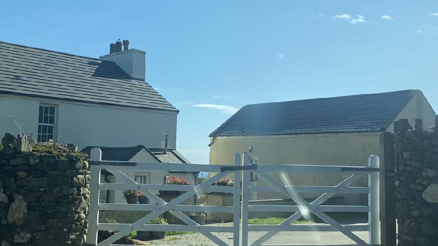
1.5 The site comprises approximately 0.08ha and includes the dwelling which is a traditional Manx cottage with a single storey, modest rear porch and an outbuilding which sits to the north west of and perpendicular to the house - see photograph below - with a small gap between the two buildings. This structure was converted to a garage along with the removal of two other outbuildings (see Planning History).
1.6 The existing curtilage is largely rectangular but steps out to encompass the outbuilding -see above.
A photograph showing a white detached house with a slate roof on the left and a detached garage or outbuilding on the right, viewed through a white gate and stone wall.
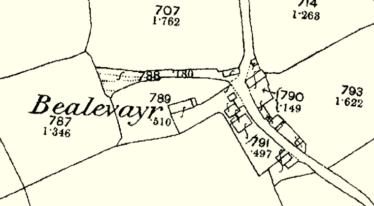
1.7 The house is undoubtedly old, appearing on the 1860s maps of the Island along withBallavayre Cottage and the stone farm building to the west, outwith this site. The farm at thatpoint was referred to as Bealevayr:
A black and white site plan or map showing property boundaries, plot numbers, and small structures along a road labeled 'Bealevayr'.
2.0 Planning policy
2.1 The site lies within an area designated on the Area Plan for the South which was adopted in 2013, as not for a particular purpose. There is therefore a presumption against development here as stated in General Policy 3 of the Strategic Plan (see Appendix One).
2.2 Whilst not specifically referred to in General Policy 3 there is provision for the extension of existing, traditional, rural houses (Housing Policy 15).
2.3 Development is generally directed towards existing settlements (Strategic Aim, Strategic Policies 1, 2 and 10, Spatial Policy 5, Housing Policy 4).
2.4 Development must also respect the environment (Strategic Policy 4) and result in a beneficial impact on the environment (Strategic Policy 5 and Environment Policy 42) and development which is harmful to the countryside is presumed against (Environment Policy
1).
2.5 There are no Constraints shown on the relevant map which accompanies the Area Plan for the South.
2.6 The site is not shown as being at risk of flooding on the national flood risk maps.
2.7 There are no Registered trees on the site, no footpaths running through the site and the site is not within a Conservation Area.
2.8 Development which is harmful to trees is presumed against (Environment Policy 3) as is development that adversely affects wildlife (Environment Policies 4 and 7).
2.9 Work to pre-1920 buildings should use traditional materials (Environment Policy 34).
2.10 General Policy 2 sets out general standards with which development is expected to comply, including some of the issues already referred to above, and matters relating to access, highway safety, preservation of the character of an area.
2.11 The loss of the highest quality agricultural land is presumed against (Environment Policy 14). The land here is Class 3 so does not fall within this category of protection.
2.12 The Area Plan formalised the draft Landscape Character Assessment which was undertaken in 2008 and considers the Island’s countryside in terms of character areas. The site falls close to the boundary of two such areas D14 (Ballamodha and St. Marks) and D15 (Port Erin and Port St. Mary Incised Slopes). The landscape strategies for these areas are summarised in the Area Plan Written Statement as follows and the full Assessment is included at Appendix Two:
D14 The overall strategy is to conserve and enhance the character, quality and distinctiveness of the area, with its wooded valley bottoms, its strong geometric field pattern delineated by Manx hedges, its numerous traditional buildings and its network of small roads and lanes. The strategy should also include the restoration of landscapes disturbed by former mining activities.
Key Views Distant views prevented at times by dense woodland in river valleys and by the cumulative screening effect of hedgerow trees, which tend to create wooded horizons. Open and panoramic views out to sea from the higher areas on the upper western parts of the area where there are few trees to interrupt views.
D15 The overall strategy for the area is to maintain and enhance the character, quality and distinctiveness of the local built vernacular and integrity of the nucleated settlements of Port Erin, Port St. Mary and Ballagawne, the scattered traditional farm dwellings and to maintain the field pattern and semi-upland character of the upper slopes.
Key Views Extensive panoramic views from higher ground on hill slopes along coast to the Calf of Man, inland over the Scarlett Peninsula and up the Southern Uplands and Meayll Hill.
Landscape Proposal 1: There should be no further new built development to the west of the existing western edge of residential development on Bradda West.
Landscape Proposal 2: Additional residential development at the edge of Port Erin, Port St Mary, or Ballafesson should include landscaping which softens the existing hard edges of the settlements and includes substantial tree-planting, such as not only
to mitigate the landscape impact of the development, but also to maintain effective separation between the settlements.
2.13 The Residential Design Guide and Planning Circular 3/91 provide advice on the design of new residential development, complementing Housing Policy 15 which requires that extensions respect the proportion, form and appearance of the existing property and in terms of size only exceptionally will permission be granted for extensions which measure more than 50% of the existing building in terms of floor space.
2.14 The Residential Design Guide introduces some more flexibility in the choice of design and materials, stating that “It is hoped that this document will encourage creative, innovative and locally distinctive designs that respond to the changing needs of our communities” and that “This document is not intended to stifle creativity or to promote planning by numbers and off the peg designs, but rather to create a supportive context for good quality designs, be they traditional or modern.” This reflects the approach being taken in respect of the availability of new materials and sometimes the appropriateness of using contrasting and contemporary materials: “However, it is recognised that in some circumstances, a distinctive break in style/finishing/details may be appropriate and there have been good examples of the use of more contemporary high quality design and finishes to traditional buildings.”
2.15 It also states, “All extensions and alterations, particularly those incorporating modern design approaches, should be considered holistically with the original/main building and its setting in the landscape/townscape to avoid an awkward jarring of materials and forms. However, well judged modern designs using contemporary and sustainable materials will be welcomed, as the Department does not wish to restrict creative designs where they can be integrated successfully into their context. Such approaches, where well designed, can serve to both improve the sustainability of buildings and significantly improve the appearance of buildings to the general benefit of the streetscene.” “However, where inappropriately designed, located, and finished, such approaches can be harmful to the character of a building and its surrounds, and become a local eyesore. Therefore, in some cases, modern design approaches will not be the most appropriate solution, and the character and form of the building and its context may require a more traditional and reserved design approach.”
3.0 Planning history
3.1 Ballavayre Farm house has been subject to proposals for alterations and extensions:
09/00298/B - conversion of out building to garage and removal of two redundant out buildings - permitted 09/00035/B - construction of front porch and installation of replacement windows - permitted 09/00984/B - remove existing render and replace with smooth render - permitted
Other sites
3.2 Ballavayre Cottage has been the subject of the following applications:
94/01746/B - alterations and construction of conservatory - permitted
96/01178/B - installation of uPVC windows - permitted (permission is no longer required for the replacement of windows in this property due to changes to the the Town and Country Planning (Permitted Development) Order)
98/01480/B - erection of car port - permitted
24/00801/LAW - certificate of lawfulness for the erection of a sunroom - pending decision
4.0 The proposal
4.1 Proposed is the extension and alteration of the cottage. This retains the outbuilding/ garage as is and introduces new fabric to the western side and the rear (north) and attaching the cottage to this existing outbuilding.
4.2 The extensions will provide a dining area and kitchen at the side with a utility area and boot room built off the existing rear porch and accessible from the garage, at the rear.
4.3 The extensions are mostly single storey but with a projecting dormer feature above the dining room to provide an en suite extension to the existing first floor bedroom on that side of the house.
4.4 The proposed extensions will add 32% to the floor area of the existing property. The applicants are considering two different approached in finish - either to finish the new fabric in a contrasting material - either timber board cladding or a more industrial metal cladding or, to use a simple render system to complement the existing buildings. The application contains drawings which show both approaches and the applicants would like the option to use either finish.
4.5 It is also proposed to extend the residential curtilage to incorporate additional land not only to accommodate the proposed extension but also to provide a more regular curtilage to the property and providing a straight boundary edge to the adjacent agricultural area. This new boundary will be demarcated with a fence and native hedge planting as shown in the proposed site plan.
5.0 Assessment
A photograph showing a cream rendered house connected to a stone outbuilding via a modern single-storey glass extension.
5.1 The most relevant policies with which the proposal should comply are those which protect the character and appearance of the countryside, in particular that guidance which relates to the alterations and extensions of existing traditional properties (Housing Policy 15, Environment Policy 1, Strategic Policies 4 and 5 and Environment Policy 42).
5.2 The works do not exceed the 50% increase guidance and whilst the policy talks of extensions respecting the proportion, form and appearance of the existing property, there have been many examples of the use of modern materials, particularly glazing, to accommodate extensions, particularly where these enable the original structure to be distinguished from any newer fabric. Indeed the Residential Design Guidance supports this approach where this would not detract from the character and appearance of the property to which they would be attached or the area more generally.
5.3 Recent examples of more contemporary additions to existing traditional dwellings include the following:
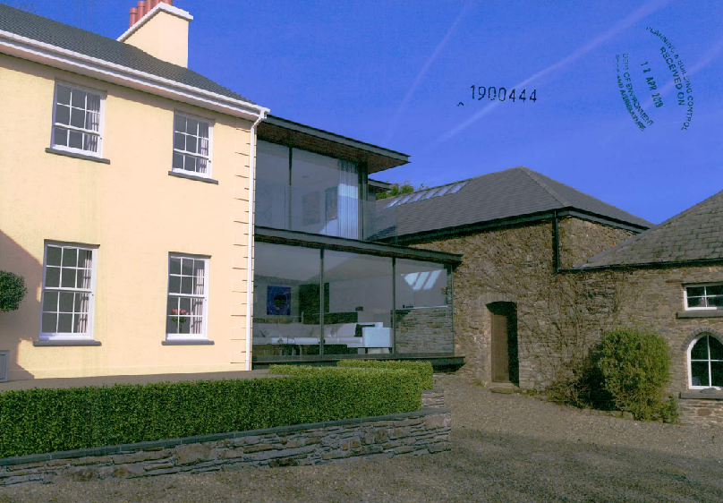
5.3.1 Permission was granted to a glazed link from a traditional house to an adjacent stone barn on the Island - 19/00444/B.
5.3.2 Permission was given to this two storey extension at Graystones, Ballakillowey Road, Rushen (12/01637/B).
5.3.3 Permission was granted for these extensions to Shenharra Cottage, Peel Road, St. John’s (22/00331/B).
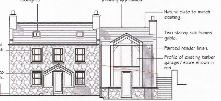
This image displays an architectural elevation drawing showing an existing stone house and a proposed two-storey oak-framed extension. Annotations detail materials like natural slate and painted render, along with the profile of an existing timber garage.
5.4 The proposed works to the house preserve the main core of the existing traditional cottage, its proportion and form and the extensions are set back from the ends of the existing elevations to maintain the existing character of the house.
Extension of curtilage
5.5 The extension of residential curtilages into the countryside falls within the general presumption against development as domestication of the countryside can have an adverse impact, reducing the natural character and openness by the introduction of mown lawns, domestic structures and hardsurfacing. However, there are many examples of where this has been considered acceptable:
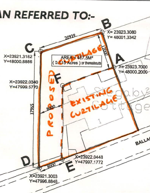
i. 13/00151/C proposed the change of use of agricultural land at the rear of 1, Slegaby Cottages in Onchan:
ii. This involved the extension of the residential curtilage 12m to the rear and 8m to the side of the existing dwelling and was refused by the Planning Committee. The inspector comments as follows:
“10. General Policy 3 and Environment Policy 1 have important aims to safeguard the Manx countryside from unwarranted development and encroachment. In this particular case, however, the dwelling has practically no residential curtilage to the side or rear, where the boundaries hug close to the building, and only a very small front garden…It would not be going too far to say that the lack of amenity space makes it deficient by present day standards. The additional
A site plan detailing the proposed and existing curtilage boundaries with coordinates and dimensions for a property extension.
residential curtilage being sought is not excessive or more than might reasonably be expected to serve this home.
General Policy 3 offers little guidance regarding proposals at existing rural dwellings. In this case I consider that use of the now enclosed land as a garden rather than as a small paddock would have little impact and, as well as improving living conditions for occupants, could well also enhance their home’s setting and appearance in the countryside. In this sense the proposal need not conflict with Environment Policy 1. There would be a small loss of agricultural land, undesirable but very limited in extent, and my conclusion does depend on the added land being used only for garden purposes without ancillary structures.”
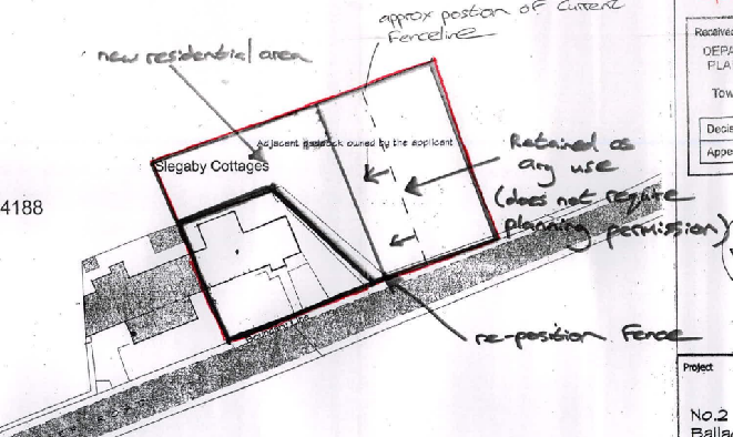
iii. 13/00019/C proposed the change of use of the neighbouring property to the one above and the inspector reached the same conclusion, reiterating paragraph 11 above for this application also.
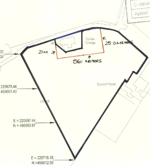
iv. 12/00999/C proposed the extension of the residential curtilage of Curlew Cottage in Castletown. This application was refused by the Planning Committee and approved at appeal, the inspector noting the following:
“11. In relation to the countryside and landscape policies, the proposal lies outside of any settlement and is not designated for development which includes extending a residential curtilage into agricultural land. In principle, therefore, the proposal is contrary to Policy EP1 which seeks to protect the countryside and its ecology for its own sake However, the polices also seeks to ensure that development would not have
A site plan with handwritten annotations indicating a new residential area, boundary adjustments, and fence repositioning near Slegaby Cottages.
any adverse visual effect and the proposal should be assessed on this basis as well as on the basis of the principle of development.
12. Having viewed the property and its existing curtilage from both near and distant viewpoints I agree with the planning officer’s view that the boundary treatment would limit views and that the increase in size is appropriate for a garden use. There have been relatively recent extensions and works carried out at the property and it is reasonable to consider whether or not any further development (including extending
A site plan showing property boundaries, dimensions, and coordinates for Curlew Cottage and Scarlett House.
the curtilage) is acceptable in relation to its impact on the character and appearance of the countryside and its landscape features.
13. With regard to Policy EP2, whilst it is clear that a larger garden area is not absolutely essential, I do not consider that the proposed additional garden land, in this particular location, would be harmful to the character and quality of the landscape in this part of the Area of High Landscape or Coastal Value and Scenic Significance. Due to the property’s specific location and the fact that distant viewpoints are very limited from all directions, the additional open garden area around the house would not result in an obtrusive or harmful visual element in this part of the countryside. From both near and distant viewpoints the proposed open space and its boundary treatment would, in my view, blend in and form a cohesive part of the landscape in this part of the Island”.
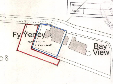
v. 14/00535/C proposed the extension of the domestic curtilage at Gull Cottage in Baldrine where the Planning Committee visited the site and approved the extension of his residential curtilage as shown right:
vii. The most recent application which is of relevance is 23/00884/C which was approved on appeal: The inspector makes the following concluding comments:
“89. Limited harm has been identified to the character of the countryside as well as harm by reason of an at face value conflict with IMSP Policies EP1, GP2 and GP3. However, I have ascribed considerable weight to the benefit of the scheme in the provision of garden space of an adequate standard to appropriately serve 4- bedroom family homes. This would be in the interests of the health and wellbeing of residents. Also weighing in the positive side of the balance in favour of the proposal, is the
A site plan sketch showing the layout of 'New Gull Cottage' with red and blue boundary lines indicating the proposed extension and curtilage area.
permission granted at a neighbouring site, Thie Cheerey where circumstances are very similar to that of this appeal. Conclusion
On balance and subject to appropriate conditions requiring comprehensive boundary planting and a restriction on what building/structures can be erected on the extended garden areas the benefits of the scheme would outweigh the limited identified harms.”
5.6 The test therefore, is whether there is any adverse visual impact from the expansion of the residential curtilage, whether there is any significant loss of productive agricultural land,
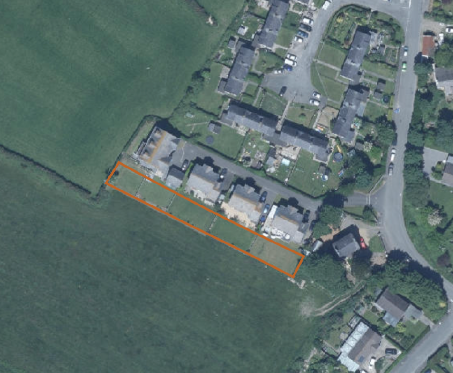
Aerial site plan showing a row of houses with an orange outline highlighting the rear garden and curtilage area.
any adverse impact on the neighbouring uses and finally whether there would be any loss of habitat or ecological value.
5.7 Due to the location of the small strip of land which is to be included in the residential curtilage, on the far side of the site from the highway, here will be no impact on the appearance of the site as it will not be visible.
5.8 The soil appears to be Class 3 which is not protected as are higher Classes.
5.9 The amount of land lost to agricultural production is very modest and arguably, due to its shape should not have a significant or adverse impact on the use of the field alongside. The aerial photograph shows this as a relatively bare area not productive growing land or where animals graze.
5.10 The additional garden area should not affect the living conditions of those in Ballavayre Cottage as there is an area of garden between it and the house and what appear to be trees between it and most of the house.
5.11 As noted in 5.9 the area does not appear to have much if any ecological value from the aerial photograph. The proposed use of this small strip of land as a garden will bring new planting and more biodiversity value than the current situation.
5.12 The proposal does not affect the requirement for parking or access.
5.13 In summary, the modest additions will allow the property to afford more comfortable living accommodation without detracting from the character or appearance of the property. The materials have deliberately been chosen to contrast with the existing render and have an agricultural flavour which sits appropriately in this rural area. The extensions are on the furthest side of the property from the road and will not be visible therefrom.
5.14 The changes to the residential curtilage will allow the garden and the adjacent agricultural field to be more easily managed and will also have no impact on the character or appearance of the area.
5.15 We would submit that the proposals comply with all of the relevant policies and guidance and are consistent with other decisions on the alteration and extension of similarly traditional properties.
Sarah Corlett 04.04.25
Appendix One - Strategic Plan policies
Strategic Aim: To plan for the efficient and effective provision of services and infrastructure and to direct and control development and the use of land to meet the community’s needs, having particular regard to the principles of sustainability whilst at the same time preserving, protecting, and improving the quality of the environment, having particular regard to our uniquely Manx natural, wildlife, cultural and built heritage.
Strategic Policy 1: Development should make the best use of resources by: (a) optimising the use of previously developed land, redundant buildings, unused and under-used land and buildings, and reusing scarce indigenous building materials; (b) ensuring efficient use of sites, taking into account the needs for access, landscaping, open space(1) and amenity standards; and (c) being located so as to utilise existing and planned infrastructure, facilities and services.
Strategic Policy 2: New development will be located primarily within our existing towns and villages, or, where appropriate, in sustainable urban extensions(2) of these towns and villages. Development will be permitted in the countryside only in the exceptional circumstances identified in paragraph 6.3.
Strategic Policy 4: Proposals for development must:
(a) Protect or enhance the fabric and setting of Ancient Monuments, Registered Buildings(1), Conservation Areas(2) , buildings and structures within National Heritage Areas and sites of archaeological interest;
(b) protect or enhance the landscape quality and nature conservation value of urban as well as rural areas but especially in respect to development adjacent to Areas of Special Scientific Interest and other designations; and
(c) not cause or lead to unacceptable environmental pollution or disturbance.
Strategic Policy 5: New development, including individual buildings, should be designed so as to make a positive contribution to the environment of the Island. In appropriate cases the Department will require planning applications to be supported by a Design Statement which will be required to take account of the Strategic Aim and Policies.
Strategic Policy 10: New development should be located and designed such as to promote a more integrated transport network with the aim to: (a) minimise journeys, especially by private car; (b) make best use of public transport; (c) not adversely affect highway safety for all users, and (d) encourage pedestrian movement
Spatial Policy 5: New development will be located within the defined settlements. Development will only be permitted in the countryside in accordance with General Policy 3.
General Policy 2: Development which is in accordance with the land-use zoning and proposals in the appropriate Area Plan and with other policies of this Strategic Plan will normally be permitted, provided that the development:
(a) is in accordance with the design brief in the Area Plan where there is such a brief;
(b) respects the site and surroundings in terms of the siting, layout, scale, form, design and landscaping of buildings and the spaces around them;
(c) does not affect adversely the character of the surrounding landscape or townscape;
(d) does not adversely affect the protected wildlife or locally important habitats on the site or adjacent land, including water courses;
(e) does not affect adversely public views of the sea;
(f) incorporates where possible existing topography and landscape features, particularly trees and sod banks;
(g) does not affect adversely the amenity of local residents or the character of the locality;
(h) provides satisfactory amenity standards in itself, including where appropriate safe and convenient access for all highway users, together with adequate parking, servicing and manoeuvring space;
(i) does not have an unacceptable effect on road safety or traffic flows on the local highways;
(j) can be provided with all necessary services;
(k) does not prejudice the use or development of adjoining land in accordance with the appropriate Area Plan;
(l) is not on contaminated land or subject to unreasonable risk of erosion or flooding;
(m) takes account of community and personal safety and security in the design of buildings and the spaces around them; and
(n) is designed having due regard to best practice in reducing energy consumption.
General Policy 3: Development will not be permitted outside of those areas which are zoned for development on the appropriate Area Plan with the exception of:
(a) essential housing for agricultural workers who have to live close to their place of work; (Housing Policies 7, 8, 9 and 10);
(b) conversion of redundant rural buildings which are of architectural, historic, or social value and interest; (Housing Policy 11);
(c) previously developed land(1) which contains a significant amount of building; where the continued use is redundant; where redevelopment would reduce the impact of the current situation on the landscape or the wider environment; and where the development proposed would result in improvements to the landscape or wider environment;
(d) the replacement of existing rural dwellings; (Housing Policies 12, 13 and 14);
(e) location-dependent development in connection with the working of minerals or the provision of necessary services;
(f) building and engineering operations which are essential for the conduct of agriculture or forestry;
(g) development recognised to be of overriding national need in land use planning terms and for which there is no reasonable and acceptable alternative; and
(h) buildings or works required for interpretation of the countryside, its wildlife or heritage.
Environment Policy 1: The countryside and its ecology will be protected for its own sake. For the purposes of this policy, the countryside comprises all land which is outside the settlements defined in Appendix 3 at A.3.6 or which is not designated for future development on an Area Plan. Development which would adversely affect the countryside will not be permitted unless there is an over-riding national need in land use planning terms which outweighs the requirement to protect these areas and for which there is no reasonable and acceptable alternative.
Environment Policy 4: Development will not be permitted which would adversely affect:
(a) species and habitats of international importance:
(i) protected species of international importance or their habitats; or (ii) proposed or designated Ramsar and Emerald Sites or other internationally important sites.
(b) species and habitats of national importance:
(i) protected species of national importance or their habitats;
(ii) proposed or designated National Nature Reserves, or Areas of Special Scientific Interest; or
(iii) Marine Nature Reserves; or
(iv) National Trust Land.
(c) species and habitats of local importance such as Wildlife Sites, local nature reserves, priority habitats or species identified in any Manx Biodiversity Action Plan which do not already benefit from statutory protection, Areas of Special Protection and Bird Sanctuaries and landscape features of importance to wild flora and fauna by reason of their continuous nature or function as a corridor between habitats.
Some areas to which this policy applies are identified as Areas of Ecological Importance or Interest on extant Local or Area Plans, but others, whose importance was not evident at the time of the adoption of the relevant Local or Area Plan, are not, particularly where that plan has been in place for many years. In these circumstances, the Department will seek site specific advice from the Department of Agriculture, Fisheries and Forestry if development proposals are brought forward.
Environment Policy 14: Development which would result in the permanent loss of important and versatile agricultural land (Classes 1-2) will not be permitted except where there is an overriding need for the development, and land of a lower quality is not available and other policies in this plan are complied with. This policy will be applied to (a) land annotated as Classes 1/2 on the Agricultural Land Use Capability Map; and (b) Class 2 soils falling within areas annotated as Class 2/3 and Class 3/2 on the Agricultural Land Use Capability Map.
Environment Policy 34: In the maintenance, alteration or extension of pre-1920 buildings, the use of traditional materials will be preferred.
Environment Policy 42: New development in existing settlements must be designed to take account of the particular character and identity, in terms of buildings and landscape features of the immediate locality. Inappropriate backland development, and the removal of open or green spaces which contribute to the visual amenity and sense of place of a particular area will not be permitted. Those open or green spaces which are to be preserved will be identified in Area Plans.
Housing Policy 4: New housing will be located primarily within our existing towns and villages, or, where appropriate, in sustainable urban extensions(1) of these towns and villages where identified in adopted Area Plans: otherwise new housing will be permitted in the countryside only in the following exceptional circumstances:
(a) essential housing for agricultural workers in accordance with Housing Policies 7, 8, 9 and 10;
(b) conversion of redundant rural buildings in accordance with Housing Policy 11; and
(c) the replacement of existing rural dwellings and abandoned dwellings in accordance with Housing Policies 12, 13 and 14.
Housing Policy 15: The extension or alteration of existing traditionally styled properties in the countryside will normally only be approved where these respect the proportion, form and appearance of the existing property. Only exceptionally will permission be granted for extensions which measure more than 50% of the existing building in terms of floor space (measured externally).
Appendix Two - Landscape Character Assessment 2008
D15 – PORT ERIN AND PORT ST. MARY Key Characteristics
• Settled and built-up areas of Port Erin and Port St. Mary around sandy beaches.
• Numerous smaller settlements, scattered houses and farms create a settled character.
• Built-up areas meet a matrix of golf courses and large rectangular fields of rough grazing, which are divided by Manx hedges and stone walls in the lower areas.
• Smaller rectangular fields on the upper slopes surround more scattered dwellings and farmsteads.
• Patches of moorland vegetation spreading into the fragmenting fields along the upland periphery.
• Isle of Man Steam Railway with stations and numerous small and large roads cut through the area.
• Variety of archaeological sites in the area including Fairy Hill and some standing stones.
• A fragmented settled rural character with roads and housing as dominant elements.
• Little tree cover in the area other than around Trinity Church, the southern edges of Ballakillowey and along the A7.
Overall Character Description The rising slopes of Bradda Hill and the Southern Uplands to the north and Meayll Hill to the south create a flat bottomed bowl. The sandy bays of Port Erin Bay lie to the west with Chapel Bay and Bay Ny Carrickey to the east. The built-up areas of Port Erin and Port St. Mary cluster along the foreshore around the beaches and spread inland into a matrix of large rectangular fields of rough grazing divided by Manx hedges with gorse and some stone walls. The rectilinear urban edges follow roads and infill development has resulted in these settlements spreading towards each other. The area towards Port St. Mary and around Four Roads, with its scattered buildings and farm houses, creates an urban hinterland with its large farm barns and large cylindrical gas tanks. Rowany Golf Course separates the definite built up northern edge of Port Erin from the numerous houses of Bradda East, Ballafesson and Surby located on lower slopes along the A32 and B47. There is a mix of stone and coloured rendered houses in a traditional style with more modern culs-de-sac housing estates on the lower upland slopes and in places such as Ballakillowey and the larger settlement of Ballakillowey in the east of the area. The extent of and distribution of such housing estates in conjunction with the larger built up areas of Port Erin and Port St. Mary results in a settled and built up character in the lower parts of this character area.
Small rectilinear pastoral fields supporting cattle and sheep, surround the houses on the rising slopes. Housing density decreases up hill with few scattered dwellings and farms on the middle slopes of Meayll Hill, south of Truggan Road and north of the linear settlement of Surby. In these more elevated areas patches of rough grass, heather and gorse begin to spread into fields as the field pattern fragments and the moorland to the north and south begins to dominate. To the east, the land flattens around Orestal to meet the southern plain and rises gently in the north east to meet the undulating, incised and less densely settled character area of Ballamodha and St. Marks.
There is little tree cover in the area other than around Trinity Church, along the southern boundary of Ballakillowey, along the A7 and alongside a number of small streams that drain the surrounding upland areas. There are few substantial trees along any of the field boundaries that are predominantly lined with gorse. The Isle of Man Steam Railway with stations and halts as well as numerous minor and major roads with roundabouts cut through the area linking the numerous settlements in the area to the rest of the Island and result in a fragmented settled character with a low sense of tranquillity.
Key Views
• Extensive panoramic views from higher ground on hill slopes along coast to the Calf of Man, inland over the Scarlett Peninsula and up the southern uplands and Meayll Hill. Historic Features
• Standing Stones
• Motte – Fairy Hill
• Trinity Church
Ecological Features
• Farmland grassland habitats
• Marginal heathland habitats on steeper upper slopes
• Mature network of hedgerows containing deciduous trees in field boundaries
• Fragmented blocks of deciduous woodland
• Small aquatic and riparian waterside habitats in the numerous small drainage ditches and water body near Trinity Church.
Evaluation of Inherent Landscape Sensitivities
• Nucleated settlements of Port Erin, Port St. Mary, Surby and Ballakillowey.
• Scattered traditional farms dwellings on upper slopes.
• Sites of archaeological importance.
• Rectangular fields with moorland vegetation spreading from Manx hedgerows on the upper slopes.
• Victorian Isle of Man Steam Railway and station.
Landscape Strategy The overall strategy for the area should be to maintain and enhance the character, quality and distinctiveness of the local built vernacular and integrity of the nucleated settlements of Port Erin, Port St. Mary and Ballagawne, the scattered traditional farms dwellings and to maintain the field pattern and semi-upland character of the upper slopes.
Copyright in submitted documents remains with their authors. Request removal