Loading document...
FORMER POUND LANE DEPOT, CASTLETOWN (POUND) ROAD, RUSHEN
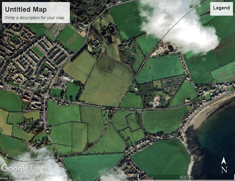
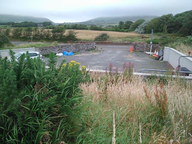
The former depot is one of several scattered ‘development’ sites along Castletown Road between Gansey / Mount Gawne and the Four Roads on the edge of Port Erin. To the east are allotments with sheds and the Southern Amenity site the entrance both of which is only 82.7m distant and to the west, two dwellings Douval and Brook Cottage 54.5m distant and then a cluster of dwellings on the roadside at the Railway Line crossing and Four Roads itself. The latter also contains the Rushen Primary School whose entrance is only 500m from the former depot, and Southern Group Practice (Health Centre). So albeit not within the formal boundaries of either Port Erin or Port St. Mary, dispersed development is very much an established feature of the area.
Scattered development in vicinity of Pound Lane Depot
The site itself was formerly used by the Highway Board as depot with containers in it. In a list of properties acquired by the former Department of Transport from the Government Property Trustees , the deed refers to the depot as having been “Paint Store” formerly Rushen Pinfold. (Deed No June 1964 / 29 attached). Elsewhere it is described as plant store so it is assumed that “Paint” is a typographical error.
In an article in the Journal of the Manx Museum 1940 the Rushen pinfold or pinpound is described as being surrounded by stone walls over 6ft high. Most of the latter still exist and a new wall has been created on the
southern edge of the site. Many pinfolds had a dwelling associated with them for the pinder but in this case the dwelling does not appear on any plan for the site.
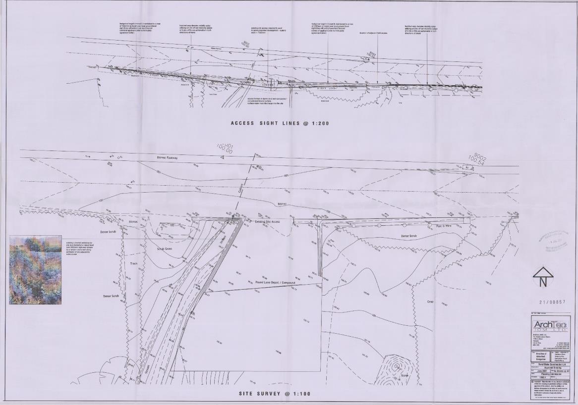
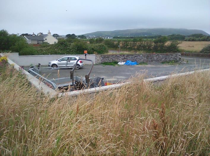
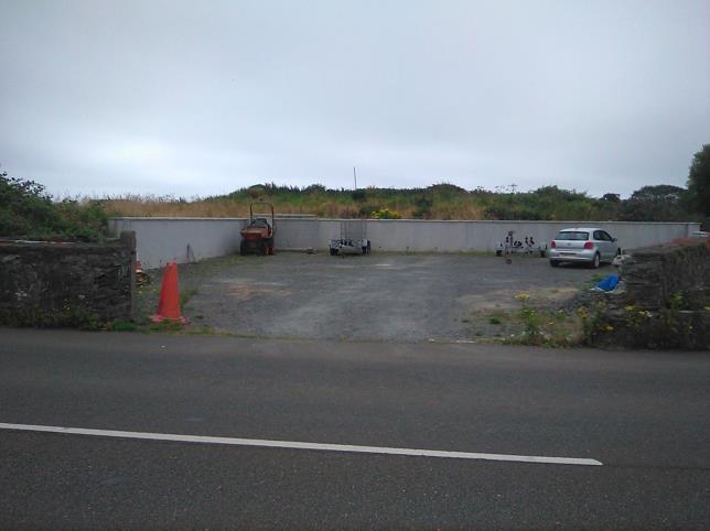
The site has a frontage to the Castletown Road of 11m, widening to 21m at its southern end and is generally 21m deep. It is level site covered in Grade 1 hardcore. Walls at the southern end of the site are 1.5m high. It covers a total of 383 square metres.
Following its use as a depot the site was left in an untidy state, and Daryl Construction was given permission to tidy up both the site and an extension to it and a hard concrete surface was laid down. An application for a certificate of lawful use of the depot was turned down as insufficient evidence of its use could be provided. As the site was not used as part of an independent commercial operation any evidence would have to be based on images and regretfully none seem to exist. However as above there is proof of the acquisition of the site for a depot by the former Department of Transport 60 years ago.
There have been a number of previous applications on the site. The current proposal is looked at in relation to the comments and assessment made in respect of these earlier applications.
PA20/00008/LAW Certificate for the use of site for storage and equipment and materials
Commissioners concerned whether this is an appropriate use for a semi -rural site. Despite a letter from the Department of Infrastructure (attached) confirming use of the site as a depot the site certificate was declined in March 2020 on the basis
“It has not been demonstrated that the use of the site for storage of materials and plant has ever been carried on in a material sense or that it has been used for such for a period of ten years. “
PA20/00996/C Levelling of site, erection of wall up to 1.5M and laying of hardcore hardstanding. The case officer noted the scope of works was
"2.2.1 The clearing out of rubble "infill" (hardcore) at the rear section of the site to existing site level of site frontage in order to form a level area for the entire site. This would make the entire site area level with the abutting highway. The site would be infilled with hardcore type 1 to ground area compacted to road level throughout site.
2.2.2 The erection of walls to join up the existing walls and to create a retaining wall to shore up the raised section at the rear sections of the site that are enclosed by the raised earth bank. This wall would be 1.5m high (matching the existing stone walls) with concrete coping stones on top and floated render finish to walling, and would form a retaining wall for the raised bank.
‘6.5 The agents advises that this land was sold as a depot (see planning history) and to some degree should be considered as previously developed land, the definition from the policy (para.3.19) seeks that there is or was a permanent structure on site, as there is none, other than a boundary wall for which permission was granted (see para.4.2) it would not necessarily be compliant in these terms with the definition or would adhere to that of General Policy 3(c) for previous developed land. ‘
The Officer’s comments with regard to the boundary wall are not totally accurate. As the site was extended to cover uneven ground to the south only the southern wall was a total replacement wall for that on the original boundary of the site and the extended parts of the east and west walls were new, the rest of the boundary walls are original.
The application was approved in December 2020 subject to Conditions
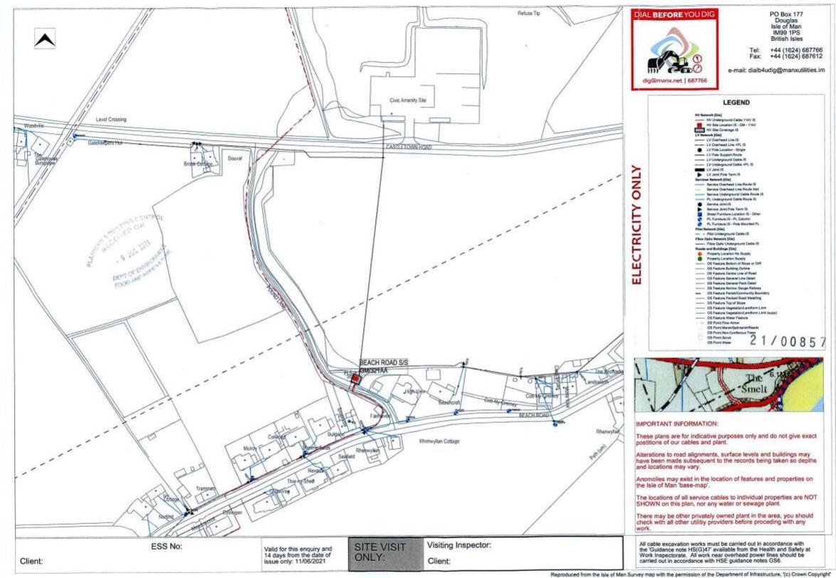
PA21/00857/B for the erection of a 2 storey dwelling and garage proposed a 3-bedroom eco home, designed to exceed required thermal values, have a solar roof and air source heat pump assisting to minimise carbon footprint. The proposal allowed for onsite parking and turning as well as a generous double garage that would allow for both cars and cycles.
In relation to application 21/00857/B the Commissioners had a number of concerns. The Commissioners note that the application is for a site not designated for residential use. They also note that there would be limited space for parking off the main road and would ask for a strongly worded condition that garage should not be converted to residential use should the application be supported. The Commissioners also noted that much of the traffic using the main road travels in excess of the 40 mph speed limit and wondered whether this had been considered by the DoI Highways officer when they wrote their supportive comments. The Commissioners are not fundamentally opposed to the proposal but do feel that it needs careful consideration particularly in relation to the points they have raised.
However the planning officer considered this to represent lack of support for the proposal. The application was refused in March 2022 on the grounds that
PA 23/00857/B Installation of a storage container for storage of expensive equipment used in association with applicants construction industry. Application withdrawn November 2023
Use and Policy The Planning Officer’s report on PA20/00996/C states ‘The site lies within an area designated on the Area Plan for the South as not for a particular purpose and thus there is a presumption against development here as stated in Environment Policy 1’. The 1982 Development Plan Order provides relevant interpretation White land is land not zoned (item 35 of notations used on the Order Map); and Existing Uses ‘Any use of the land existing at the state of the of the coming in of this Provisional Order not being a temporary use of land controlled by the terms and conditions of any approval granted to such use of the land, and not being in conformity with the zoning of such land in the plan shall be allowed to continue until such time as a Supplementary Order shall make provision for its discontinuance.’
As the land remains unzoned a use cannot be at variance with it. This does not mean that the land has no use. Its former use as a depot ceased less than 10 years ago. Notwithstanding the fact that the Planning Department has previously not acknowledged that the site was used as a depot (PA20/00008/LAW) the continued use for this purpose is, as witnessed by the sale of the land by the Highways Division, redundant. The Planning Department have already allowed development of the site in enabling its tidying up, resurfacing and the relocation of its southern wall and additions to East and West wall.
It therefore has status as previously developed land. Consent under this application would enable the construction of a high quality dwelling in compliance with current sustainable building standards.
Highways 21/00857/B The officer’s report states
2.4 Access to the site would utilise the existing entrance with modification to allow for the correct visibility splays (2.4m x 47m) in both directions and an entrance width of 7.0m wide. The hedgerow and boundary wall to be kept to below 1.05m to maintain clear sight lines for visibility. Whilst the land is not owned by the applicant a third party agreement letter has been provided to support the application and maintenance of the laneway.
Access arrangements as included in PA 21/00875/B to which highways agreed
In response to PA21/857/B DOI Highway Services stated “After reviewing this Application, Highway Services find it to have no significant negative impact upon highway safety, network efficiency and /or parking. There is an existing dropped crossing and adequate visibility. Storage for bicycle parking and an electric vehicle charging point should be considered to aid climate change objectives.”
As the proposal was both then and now for a single 3-bedroom house, the same access and visibility splays to which Highways Division had no objection previously have been put forward. An electric vehicle charging point and a potential location for a shed for cycle / garden implement storage has been included.
In PA20/00996/C the Planning Officer reported
‘6.3 Given the broad location of the site and its location, it does not sit within a remote part of the countryside where there are no provisions for accessible transport. The site is adjacent to a highway where there is public transport available and would be approx. 1.3 miles from Port Erin shops and the same from the shops and service at Port St Mary. As such it is a fine balance whether this aspect in isolation would be contrary to Strategic Policy 10 (a)-(d).’
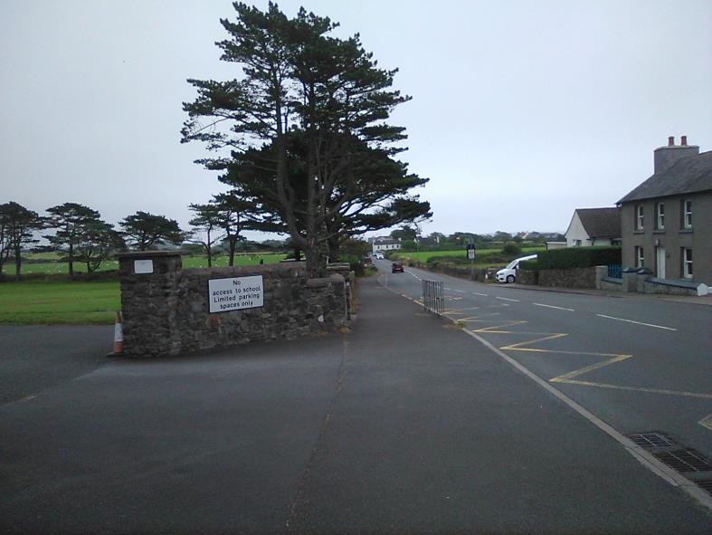
Access to Rushen Primary School 500m to the west; pavement is continuous from opposite the site. G As noted in PA21/00857/B ‘However the site does sit on a service road where there are some residential dwellings to the south of the highway along its length and easily accessible from the highway’.
Given also the site is within walking distance of a primary school – 500m -, health centre, shops and community facilities and there is a continuous pavement on the opposite side of the Castletown Road to these from the site and there is a public right of way immediately to the west of the site linking it to the A31 Port St Mary road to the south the proposal clearly complies with Strategic Policy 10. As it is a requirement that all applications also meet the standards for provision of parking spaces - Strategic Plan Transport Policy 7 and Appendix 7, - and turning it is inevitable that the site makes provision for motor vehicles whether or not it is in a town or village.
There is no case for stating that it is in an unsustainable location so far as highways, transport and utilities are concerned. It is fully in accord with Strategic Plan Policy 10 and Transport Policies 1, 4, 6 and 7.
On the Flood Hub maps the north-west corner of the site is shown as being in an Area of High Risk of River and Tidal Flooding and the Castletown Road as subject to river flooding.
Flood hub map December 2024
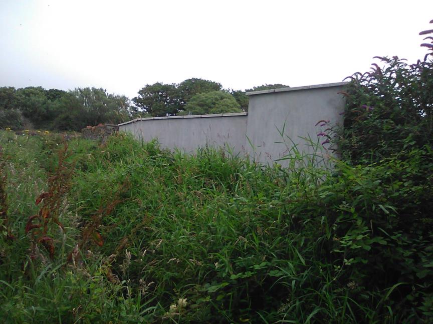
In practice the site is above the adjacent road level which dips down to the west and under which a stream is culverted. On the west side of the application site there are 1.5m high walls which both bound the site and protect it from the course of the stream which is upto 2.5 m below the base of the walls.
Wall on west side of depot high above stream
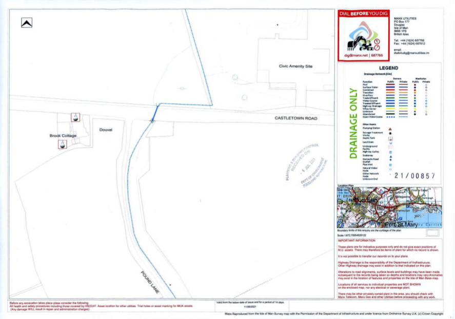
In response to PA21/00857/B Highways Drainage commented (13/08/21) seeking a private drainage scheme to avoid surface water runoff onto the highway.
The applicant has commissioned an independent assessment by Axis Consulting Engineer whose report of September 2024 is attached separately. The conclusion is that the site can be drained adequately to the
downstream ie south side of the culvert and therefore both not be affected by flooding and not add to any flooding of the road that may periodically occur or pollution of the watercourse.
An Aco surface water drainage channel is proposed to be installed within site at head of driveway.
The site is not within an area of High Landscape Value on the 1982 Development Plan and as such, Environment Policy 2 is not applicable. On the draft Landscape Character Appraisal which is incorporated into the Area Plan for the South, the site lies within an area of Incised Slopes and where the site is not identified in particular but the overall objective in the landscape strategy is to preserve the existing rural character appearance and distinctiveness of the area.
In the officer’s report on PA20/00996/C it was stated
‘3.2 Within the written statement for the area plan for the south; the site or surrounding area is not specifically identified but being surrounded by agricultural land the overall objective in the landscape strategy is to preserve the existing rural character appearance and distinctiveness of the area.’
Also
“6.3 As indicated the levelling works involved the excavation of sections of the site which resulted in the increase in the site area that is level with the highway and reduction in the size of elevated sections of the site. These works when completed would change the appearance of the landscape around the site, especially when viewed from the abutting highway and surrounding fields, albeit, the works would tidy up the area and improve the appearance of the landscape; creating a uniform appearance with the surrounding area; as the site is the only part of the landscape south of the 20/00996/C highway currently in poor form. As such, it is considered that the proposal would comply with Environment Policy 1.
6.4 In terms of the impact on the visual amenity of the street scene, it could be argued that the works would be in keeping with the character of the street scene given that the Manx stone wall which is a common feature within the street scene would be preserved. In addition, the works would tidy up the site area and ensure that the site area ties in with the appearance of the surrounding sites with the undulating green surrounding blending in with the graded sections on the southern end of the site when the grass is fully grown. Therefore, it is considered that the impact of the proposed material alteration of the site upon the visual amenity and openness of the area would be positive and would accord with Strategic Policy 4 (b & c).” As above the character of the area is very much one of scattered development. Other than the stream side there are no “incised slopes” locally. The site has been clearly demarcated by its boundary walls on the north, west, east and south (albeit with some alteration / extension) as a separate site in separate use from the adjacent field to the east for over 150 years. The ground to the south of the site is at a higher level and with its existing vegetation will naturally help to screen the development.
Pound Lane Depot showing existing higher ground and existing vegetation to south of depot
Proximity of Pound Lane Depot to Douval and Brook Cottage – approximately 50m distant
While there may not have been permanent buildings on it, its use as a depot by large vehicles entering and exiting it gave it a very different character from the adjoining land uses. The use for a single dwelling would not be out of character; it would give permanence to the site and result in its permanent clearance and being kept tidy and free from grass and weeds. This would be preferable to permitting it to degenerate back to being overgrown and disused which the owner has spent much effort and finance to stop happening but which, with the continual refusal by planning to acknowledge past uses of the site or to allow positive use for the site, it will inevitably revert to.
Biodiversity In response to PA 21/00857/B the Ecosystem Policy Team stated
‘ have no objection to the proposed development. However, we note that the dwelling is to be located in open countryside, on land containing a mixture of semi-natural vegetation, that will be being used by a variety of wildlife. As mitigation for the loss of semi-natural vegetation and to ensure that there is no net loss for biodiversity on site, The Ecosystem Policy Team recommend that a condition is secured for a couple of
integrated House Sparrow or Starling nest bricks to be installed high up on the northern, eastern or western elevation of the new dwelling and plans showing the type and location should be submitted to Planning for written approval. We also request that a condition is secured for creation to be undertaken around the site.’
The ecosystem policy team seem to have based their comments on older photographs of the site as the whole site had by then been levelled and covered in hardcore hardstanding. Therefore there was and is no semi-natural vegetation or biodiversity to lose on the site and this remains the case at present. The proposal includes garden planting but as the site is enclosed by a boundary wall on all sides creation of boundary planting or sod bank creation, particularly when the wall on the south side of the site is a retaining wall against the higher bank which is outside of the applicant’s ownership, any suggestion for Manx native boundary planting or sod bank is not practical given the limited size of the site and the necessity to provide adequate parking and turning space within it.
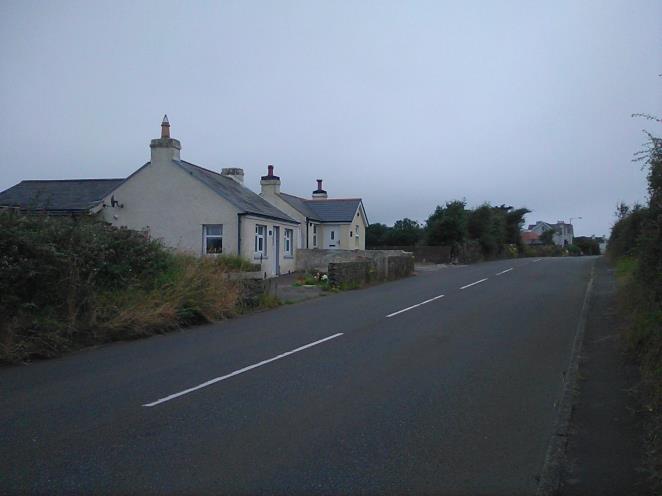
Design PA21/00857/B planning officer’s report states ‘the nearest adjacent properties are two residential dwellings to the west - Douval and Brook Cottage’, both on the south side of Castletown Road. ‘These are both bungalows with pitched roofs and bookended with chimney stacks‘.
Douval and Brook Cottage
Beyond them to the west is also the single storey former crossing keeper’s cottage beside the steam railway crossing.
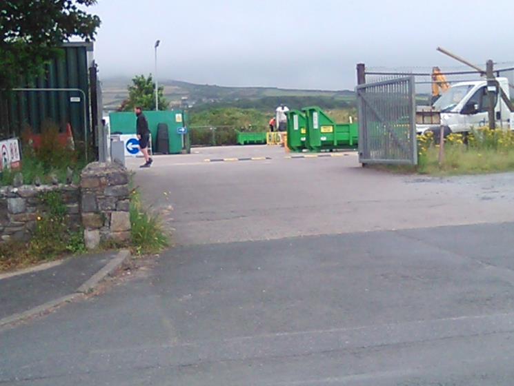
On the other side of the road from the site, slightly to the east, is the Southern Civic Amenity site and Port St Mary allotments site, both of which contain several portacabins / huts.
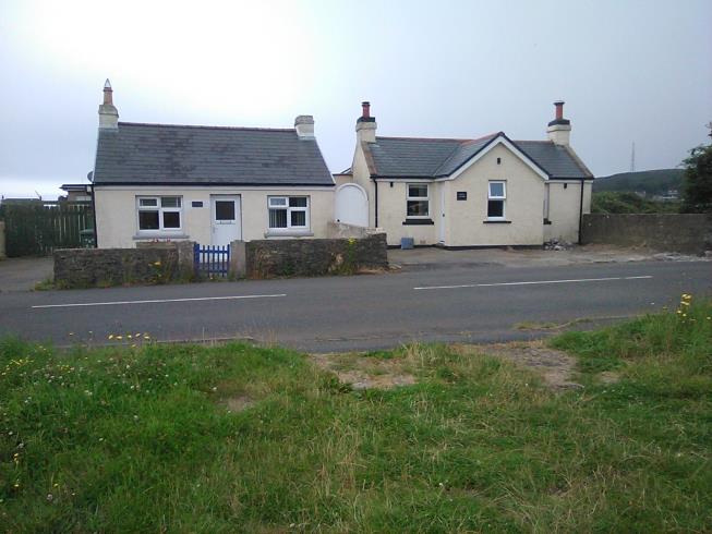
Amenity site with portacabins to the East
The character of the locality is therefore of agricultural fields regularly interspersed with single storey development between the more built up areas of Gansey / Mount Gawne and Four Roads / Port Erin. The proposal has been designed to fit in with this being screened on the south side by the existing rise in land level.
The proposed dwelling is low profile only 4.3m high to a ridge itself only 5.5m long with hipped roof profiles over projecting rectangular bays, anthracite colour Marley Birkdale or comparable roofing tiles. It will have smooth rendered painted walls, dark grey colour stone cladding panels on either side of the front bays, panels of dark grey colour composite weather boarding below the windows and anthracite colour high performance upvc windows and doors,
With regard to energy performance the dwelling will have 320 watt JA Solar Edge modules with flashing kits on the roofs, air source heat pump and electric vehicle charging point.
The design, size and scale of the proposed dwelling, and its finishes, are therefore equivalent to those used on the older dwellings of Douval and Brook Cottage , the latter also having a forward projecting bay at the front. They are sympathetic to the rural character of the area. Keeping the proposed dwelling low profile and single storey will not constitute over development of the site. The proposal does not have an adverse visual impact being set back 10.5m from the roadside frontage. It is therefore in conformity with Strategic Policy 5 and General Policy 2 (b & c) of the Strategic Plan.
While the site is technically in the countryside, the nature of that countryside and, in particular of the site itself, is not that of a countryside locality having been used for around 50 years for non-countryside uses in a locality characterised by sporadic development and itself comprising a well-defined compound with a hardcore hardstanding. In this location the proposed development will not adversely affect the countryside; there is no requirement to prove national need in such circumstances. The development therefore does not overly breach Environment Policy 1 the background to which acknowledges that the not all localities fit into the categories of landscape assessment to which they are assigned.
The development has no impact on the amenity of existing residential properties – the nearest residential properties being 54.5m distant - and there have been no comments by these properties with regard to previous applications on the site.
Electricity, water supply and telephone connections are all feasible to adjoining services in the main road and under the public footpath in Pound Lane to the substation at its southern end.
Electricity, water and telephone services under pavement on opposite side of Castletown Road from site
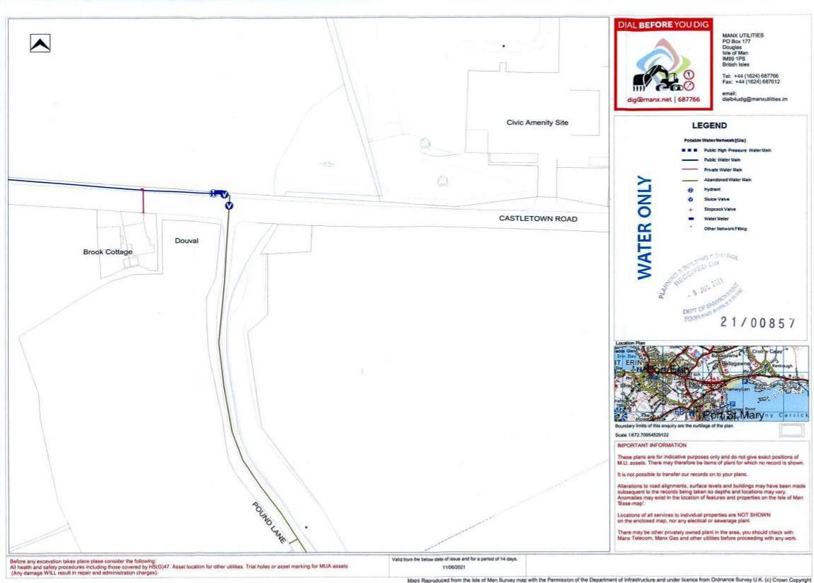
Properties to west are served by septic tanks. Proposal includes use of Klargester.
The site, comprising a former Department of Infrastructure depot, is an existing resource which is unused / under used. Its reuse even with a change of use would comply with Isle of Man Strategic Plan Strategic Policy 1.
There is no potential practical use of the site which would not involve built development and or movement of significant amount of vehicles into and out of the site. Given also the contained nature of the site the proposal should be considered as complying with Strategic Policy 2 and Housing Policy 4 as the latter only requires development to be “primarily”, ie not totally, within existing towns and villages and previous officer reports have acknowledged the mixed character of the area with roadside development.
As it is an existing self-contained site the proposal does not reduce the physical separation between settlements nor encourage their coalescence. It is therefore in compliance with Strategic Policy 3.
The site / proposal does not impact on any of the built heritage designations or natural heritage designations of Strategic Policy 4 and does not result in unacceptable environmental pollution or disturbance.
The proposal is designed in size and mass to equate to other existing development in the locality in compliance with Strategic Policy 5.
The site is within walking distance of school, shops, health centre, community facilities and bus routes. It is adjacent to public utility services. It is a SUSTAINABLE site in compliance with Strategic Policy 10.
In relation to Strategic Plan General Policy 2
The applicant would therefore submit that the proposal for one house on the site should be permitted.
The applicant would therefore submit that the proposal for one house on the site should be permitted.
Copyright in submitted documents remains with their authors. Request removal
View as Markdown