Planning Statement For The Erection Of Stable Building, Ballalsleig, Ballacorey Road, Bride Im74El
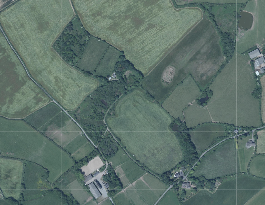
Aerial site location map displaying a rural landscape with fields, hedgerows, and scattered buildings.
1.0 Introduction
1.1 The site is a holding of approximately 11 acres which is located on the northern side of the Ballacorey Road (C15) which links the Bride Coast Road (A10) with the Andreas Road (A9).
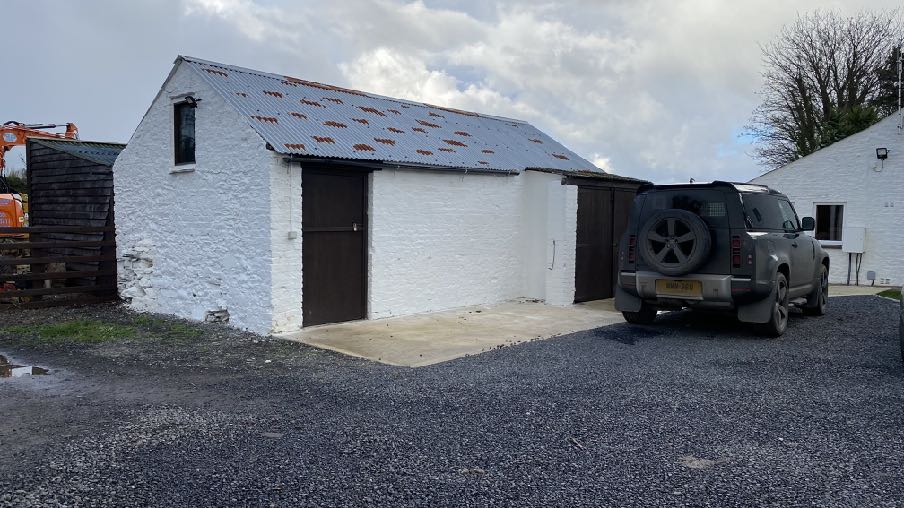
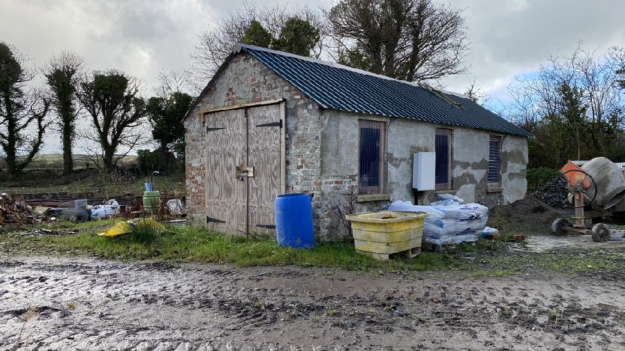
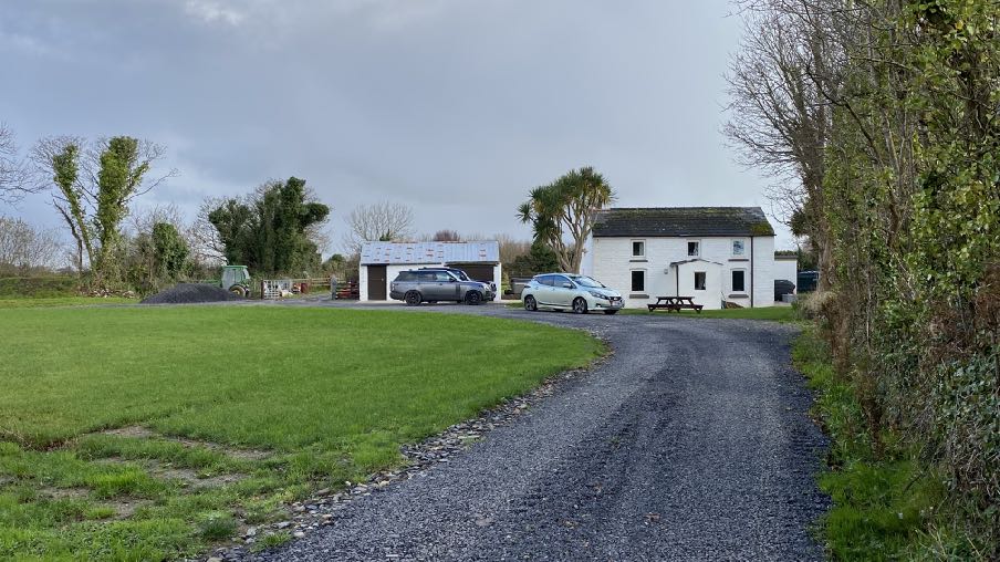
1.2 The holding accommodates some existing buildings including an existing occupied dwelling (Ballasleig Croft), a former dwelling which has planning approval for replacement with a dwelling, which is understood to have commenced, and an outbuilding with timber shed behind.
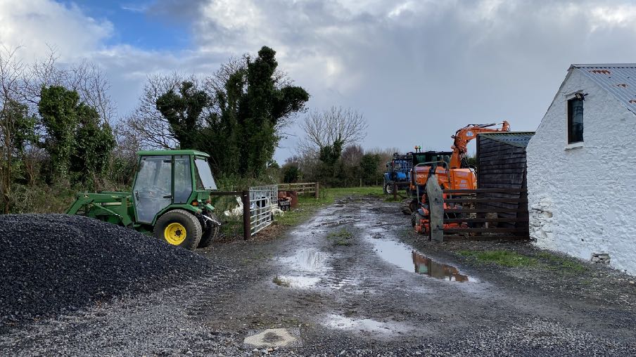
Existing outbuilding with timber shed behind
A photograph of a white-washed stone outbuilding with a corrugated roof and large wooden doors, situated on a gravel driveway with a car parked nearby.
Existing former dwelling approved to be replaced by a new dwelling
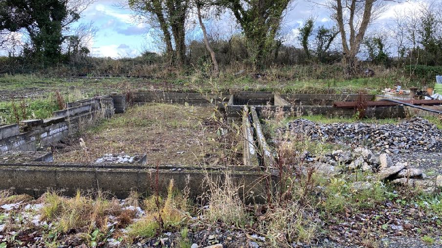
Existing footings for the approved new dwelling
A photograph of a stone barn-like building with a slate roof, surrounded by construction materials and a cement mixer in a rural setting.A photograph showing an overgrown concrete foundation base on a rural site, likely the existing ground conditions for the proposed stables.
Existing Ballasleig Croft and outbuilding
1.3 The site some way from the public highway and along a winding private lane which renders the existing buildings incapable of being seen by the public.
2.0 THE PROPOSAL
2.1 Proposed is the erection of a stable building. This is to be erected to the south west of the existing shed and alongside existing trees which sit to the south.
2.2 The stable is to have a footprint of 11.4m by 3.95m with an overhanging canopy which projects a further 1.35m to the front.
2.3 The stable is to accommodate two stalls and a central tack room/third stall - all with stable doors to the front (north) and a small window at the rear.
2.4 The building will be constructed in timber and have a sheeted or shingle roof.
2.5 Surface water will be channelled to the existing ponds within the site, close to the proposed building.
2.6 The stable will be built alongside a private lane and alongside an existing paddock.
2.0 Planning policy
2.1 The starting point for the determination of any planning application is the land use designation in the relevant adopted development plan. In this case this is the Isle of Man Planning Scheme (Development Plan) Order 1982 although this is in the process of being updated by the Area Plan for the North and West. On the 1982 Plan (below) the site is within an area not designated for a particular purpose and not part of an area of an area of High Landscape or Coastal Value and Scenic Significance.
2.2 In this part of the Island, the Isle of Man Planning Scheme (Development Plan) Order 1982 is being replaced by a new Area Plan (for the North and West). This is currently in draft form, although was the subject of a public inquiry in July 2024 with the inspector’s report having been received in October, 2024 and published in November 2024, so has only limited weight, but confirms the designation of the site as not for any particular purpose. This also has maps which show specific constraints, including the Environmental Constraints and Infrastructure constraints. The Environmental Constraints Map shows the central area where the buildings are located as of Ecological Interest although the site of the proposed stable is located outside of this.
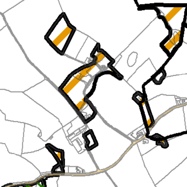
A cropped map view showing highlighted areas with thick black borders and orange strips, likely indicating a site location or specific land parcels.
2.3 There are no Infrastructural Constraints shown on the relevant map and the site is not shown on the national flood risk maps as being at risk of flooding although close to an area shown as being at risk of surface water flooding.
2.4 Trees are generally protected under the Isle of Man Strategic Plan Environment Policy 3 although there are no Registered Trees on the holding.
2.5 Ecology is protected under Environment Policies 4 and 7. The site is not designated as of ecological importance (see above).
2.6 There is a general presumption against development in undesignated areas, as set out in General Policy 3 of the Strategic Plan (see Appendix One). Environment Policy 1 presumes against development which would be harmful to the character and appearance of the countryside.
2.7 This site lies within an area on the Landscape Character Assessment as part of a large area of Undulating Lowland Plain (F3). The full advice on this type of area is set out in Appendix Two with the most relevant parts highlighted. The draft Area Plan summarises this
as follows with a relevant Landscape Proposal:
6.4.3 The Undulating Lowland Plain of Andreas and Jurby (F3) encompasses a swathe of farmland underlain by the predominantly flat topography of the northern plain. To the west, the narrow course of the Lhen trench meanders through the landscape. The main A19 and A17 roads cross the area interlinking with a network of minor roads often lined with tall Manx sod banks. Settlement pattern is scattered and relatively isolated with the Andreas and Jurby Industrial Estates and IOM prison providing the largest groups of buildings within the area. Overall, there is a strong sense of tranquillity and openness. A strong recognisable sense of place is provided by views to the dramatic backdrop of the Uplands to the south, views of St. Patrick’s Church and distant views to the sea
at the eastern and western edges of the area.
Landscape Strategy To conserve and enhance: a) the character, quality and distinctiveness of this rural area including the scattered settlement pattern, relatively strong field pattern delineated by a mixture of stone walls and relatively tall Manx hedge-banks and its network of enclosed minor rural roads
Key Views - Glimpsed views to the sea from the eastern and western edges of the area. Panoramic open views southwards towards a dramatic upland backdrop. Open views to landmark church towers (particularly St. Patrick’s Church) to the west of Jurby.
Landscape Proposal 7 The established wooded character of the Sulby River Lhen Trench and surrounding area which affords channelled views within the landscape shall be preserved. Development proposals must demonstrate that the impacts upon landscape character have been considered, and the design of any future proposal is adequately sympathetic to, and informed by the established landscape character. Dramatic views to the adjacent southern uplands shall not be impaired.
2.8 Whilst there is a presumption against development in this area according to General Policy 3 pf the Strategic Plan, there is provision for the erection of buildings for agriculture within GP3 and also or equestrian pursuits (Environment Policies 19, 20 and 21). EPs 19, 20 and 21 are the most relevant to this current application:
Environment Policy 19: Development of equestrian activities and buildings will only be accepted in the countryside where there will be as a result of such development no loss in local amenity, no loss of high quality agricultural land (Classes 1 and 2) and where the local highway network can satisfactorily accommodate any increase in traffic (see Environment Policy 14 for interpretation of Class 1 and 2).
Environment Policy 20: There will be a presumption against large scale equestrian developments, which includes new buildings and external arenas, in areas with High Landscape or Coastal Value and Scenic Significance unless there are exceptional circumstances to override such a policy.
Environment Policy 21: Buildings for the stabling, shelter or care of horses or other animals will not be permitted in the countryside if they would be detrimental to the character and appearance of the countryside in terms of siting, design, size or finish. Any new buildings must be designed in form and materials to reflect their specific purpose; in particular, cavity-wall construction should not be used.
2.9 The highest quality agricultural land (Classes 1 -2 including 2/3 and 3/2) will be protected from development (Environment Policy 14). The soil here is Class 3/2.
2.10 Development is expected to comply with the general standards set out in General Policy 2 of the Strategic Plan:
General Policy 2: Development which is in accordance with the land-use zoning and proposals in the appropriate Area Plan and with other policies of this Strategic Plan will normally be permitted, provided that the development:
(a) is in accordance with the design brief in the Area Plan where there is such a brief;
(b) respects the site and surroundings in terms of the siting, layout, scale, form, design and landscaping of buildings and the spaces around them;
(c) does not affect adversely the character of the surrounding landscape or townscape;
(d) does not adversely affect the protected wildlife or locally important habitats on the site or adjacent land, including water courses;
(e) does not affect adversely public views of the sea;
(f) incorporates where possible existing topography and landscape features, particularly trees and sod banks;
(g) does not affect adversely the amenity of local residents or the character of the locality;
(h) provides satisfactory amenity standards in itself, including where appropriate safe and convenient access for all highway users, together with adequate parking, servicing and manoeuvring space;
(i) does not have an unacceptable effect on road safety or traffic flows on the local highways;
(j) can be provided with all necessary services;
(k) does not prejudice the use or development of adjoining land in accordance with the appropriate Area Plan;
(l) is not on contaminated land or subject to unreasonable risk of erosion or flooding;
(m) takes account of community and personal safety and security in the design of buildings and the spaces around them; and
(n) is designed having due regard to best practice in reducing energy consumption.
3.0 Planning history
3.1 The site has been the subject of a number of applications concerning the cottage and the former dwelling on the site and also for proposed new buildings.
3.2 09/01607/B proposed the erection of two timber agricultural buildings: these were to be 10m by 15m and 25m by 15m respectively and the application was refused for the reasons that it had not been demonstrated that there was sufficient agricultural need to override the presumption against development here and noting that the site did not represent a viable agricultural holding due to its size and also the amount of trees which would be lost to facilitate the new buildings would result in an adverse impact on the landscape.
3.3 A contemporaneous application for alterations and extension of the existing cottage was also refused. 09/01601/B proposed a significant two storey extension to the cottage which was refused for the reason that the size and design would detract from and not respect the traditional character of the property, and thus fail Housing Policy 15.
3.4 A series of applications saw approval granted for the replacement of the former dwelling, Sycamore Cottage, to the east of the cottage: 99/02218/A was approved in principle with 00/00790/B refused initially but permitted on review (no details are available online). However, a subsequent application, 06/01821/B was approved providing the details of the replacement house. It is understood that this permission has commenced (see photographs above).
4.0 Assessment
4.1 The site lies within an area which is not designated for development but the Strategic Plan makes it clear that development associated with equestrian facilities can be acceptable if there is no adverse impact on the environment, citing local amenity and highway safety as well as the impact on the character and appearance of the countryside in terms of siting, design, size or finish. The buildings must also be appropriate to their function.
4.2 The site extends to around 11 acres and is to be used to accommodate horses as well as a small number of sheep. There is currently nowhere for livestock or equipment to be stored inside within the site.
4.3 The site lies in an area where the soil is Class 3/2 but the area where the stable is to be located is not used for agricultural purposes and is part of a paddock. As such there will be no significant or unacceptable loss of high quality agricultural soil as a result of the proposal, this complying with EP14.
4.4 The building would not result in any loss of local amenity as it is not publicly visible nor close to any other residential property other than that of the applicant. There will be no increase in traffic as a result of the proposal, arguably there could be a reduction in that better facilities and storage on site may reduce the number of visits to the site and equipment may be stored safely inside, promoting the longevity thereof. The proposal will not significantly change the amount of traffic using it and as stated above, might actually reduce traffic. The proposal is not therefore in conflict with EP19.
4.5 The building is very modest, not large scale and in any case not proposed within an area of an area of High Landscape or Coastal Value and Scenic Significance. The proposal is therefore not in conflict with EP20.
4.6 Whilst the Landscape Character Assessment refers to traditional buildings in render and slate, the policies on equestrian development require that buildings are built appropriate to their function and a blockwork and slate building would not only be more visible and eye catching but would also be more permanent and potentially contrary to Environment Policy
21.
4.7 The use of the land for grazing is technically compliant with the definition of agriculture in the Strategic Plan but approval is also sought, if needed for the use of the land for the keeping of horses which is not considered to have an adverse impact any more than if the land were used for grazing by an agricultural animal and it is the applicant’s intention to also keep sheep on this site.
4.8 We believe that there will be a significant improvement in both animal welfare as a result of more structurally sound and thermally efficient stabling for the animals, and little or no visual impact in that the proposed building will not be publicly visible but in any case is of a style and construction appropriate to its purpose and something not out of keeping in a rural landscape.
4.9 The development will allow the site to be used for agricultural and equestrian purposes, which is appropriate for its rural location, without any adverse impact on adjacent residential property, highway safety, the character or appearance of the countryside, ecology, landscape or the use of surrounding land, all in compliance with General Policy 2, Environment Policies 1, 14, 19, 20 and 21 whilst conserving and enhancing the character, quality and distinctiveness of this rural area including the scattered settlement pattern, relatively strong field pattern delineated by a mixture of stone walls and relatively tall Manx hedge-banks and its network of enclosed minor rural roads in accordance with the Landscape Character Assessment and protecting key views in accordance with Landscape Proposal 7 of the draft Area Plan for the North and West.
Sarah Corlett
22.11.2024
Appendix One - policies
Strategic Plan
General Policy 3: Development will not be permitted outside of those areas which are zoned for development on the appropriate Area Plan with the exception of:
(a) essential housing for agricultural workers who have to live close to their place of work; (Housing Policies 7, 8, 9 and 10);
(b) conversion of redundant rural buildings which are of architectural, historic, or social value and interest; (Housing Policy 11);
(c) previously developed land(1) which contains a significant amount of building; where the continued use is redundant; where redevelopment would reduce the impact of the current situation on the landscape or the wider environment; and where the development proposed would result in improvements to the landscape or wider environment;
(d) the replacement of existing rural dwellings; (Housing Policies 12, 13 and 14);
(e) location-dependent development in connection with the working of minerals or the provision of necessary services;
(f) building and engineering operations which are essential for the conduct of agriculture or forestry; (g) development recognised to be of overriding national need in land use planning terms and for which there is no reasonable and acceptable alternative; and
(h) buildings or works required for interpretation of the countryside, its wildlife or heritage.
Environment Policy 1: The countryside and its ecology will be protected for its own sake. For the purposes of this policy, the countryside comprises all land which is outside the settlements defined in Appendix 3 at A.3.6 or which is not designated for future development on an Area Plan. Development which would adversely affect the countryside will not be permitted unless there is an over-riding national need in land use planning terms which outweighs the requirement to protect these areas and for which there is no reasonable and acceptable alternative.
Environment Policy 3: Development will not be permitted where it would result in the unacceptable loss of or damage to woodland areas, especially ancient, natural and seminatural woodlands, which have public amenity or conservation value.
Environment Policy 4: Development will not be permitted which would adversely affect:
(a) species and habitats of international importance:
(i) protected species of international importance or their habitats; or
(ii) proposed or designated Ramsar and Emerald Sites or other internationally important sites.
(b) species and habitats of national importance:
(i) protected species of national importance or their habitats;
(ii) proposed or designated National Nature Reserves, or Areas of Special Scientific Interest; or
(iii) Marine Nature Reserves; or
(iv) National Trust Land.
(c) species and habitats of local importance such as Wildlife Sites, local nature reserves, priority habitats or species identified in any Manx Biodiversity Action Plan which do not already benefit from statutory protection, Areas of Special Protection and Bird Sanctuaries and landscape features of importance to wild flora and fauna by reason of their continuous nature or function as a corridor between habitats.
Some areas to which this policy applies are identified as Areas of Ecological Importance or Interest on extant Local or Area Plans, but others, whose importance was not evident at the time of the adoption of the relevant Local or Area Plan, are not, particularly where that plan has been in place for many years. In these circumstances, the Department will seek site specific advice from the Department of Agriculture, Fisheries and Forestry if development proposals are brought forward.
Environment Policy 14: Development which would result in the permanent loss of important and versatile agricultural land (Classes 1-2) will not be permitted except where there is an overriding need for the development, and land of a lower quality is not available and other policies in this plan are complied with. This policy will be applied to
(a) land annotated as Classes 1/2 on the Agricultural Land Use Capability Map; and
(b) Class 2 soils falling within areas annotated as Class 2/3 and Class 3/2 on the Agricultural Land Use Capability Map.
Environment Policy 15: Where the Department is satisfied that there is agricultural or horticultural need for a new building (including a dwelling), sufficient to outweigh the general policy against development in the countryside, and that the impact of this development including buildings, accesses, servicing etc. is acceptable, such development must be sited as close as is practically possible to existing building groups and be
appropriate in terms of scale, materials, colour, siting and form to ensure that all new developments are sympathetic to the landscape and built environment of which they will form a part. Only in exceptional circumstances will buildings be permitted in exposed or isolated areas or close to public highways and in all such cases will be subject to appropriate landscaping. The nature and materials of construction must also be appropriate to the purposes for which it is intended. Where new agricultural buildings are proposed next to or close to existing residential properties, care must be taken to ensure that there is no unacceptable adverse impact through any activity, although it must be borne in mind that many farming activities require buildings which are best sited, in landscape terms, close to existing building groups in the rural landscape.
Environment Policy 19: Development of equestrian activities and buildings will only be accepted in the countryside where there will be as a result of such development no loss in local amenity, no loss of high quality agricultural land (Classes 1 and 2) and where the local highway network can satisfactorily accommodate any increase in traffic (see Environment Policy 14 for interpretation of Class 1 and 2).
Environment Policy 20: There will be a presumption against large scale equestrian developments, which includes new buildings and external arenas, in areas with High Landscape or Coastal Value and Scenic Significance unless there are exceptional circumstances to override such a policy.
Environment Policy 21: Buildings for the stabling, shelter or care of horses or other animals will not be permitted in the countryside if they would be detrimental to the character and appearance of the countryside in terms of siting, design, size or finish. Any new buildings must be designed in form and materials to reflect their specific purpose; in particular, cavity-wall construction should not be used.
Appendix Two
Landscape Character Assessment
F3 ANDREAS AND JURBY Key Characteristics
• Swathe of farmland (covering the breadth of the Island).
• Irregular pattern of medium-sized arable and pasture fields.
• Field boundaries demarcated by traditional Manx hedges and simple post and wire fences.
• Inter-linking network of minor rural roads serve the area, together with the A10, A17 and A19.
• Generally few vertical elements, other than occasional telegraph poles.
• Scattered and relatively isolated settlement pattern.
• Traditional farm buildings (characteristically white, with grey roofs).
• Key settlements include the small town of Andreas and the villages of Bride, Jurby and Sandygate.
• The Isle of Man Government Industrial Estate and adjacent Jurby Aerodrome
• Disused airfield at Andreas
• Churches provide prominent landmarks within views.
• Views to dramatic upland backdrop to the south provide strong sense of place.
• Strong sense of openness and tranquillity (at distance from main A19 and A17 roads).
• Slightly marked sinuous valley of Lhen Trench.
• Sandpit at Cronk-y-Scotty
Overall Character Description Situated to the north of the Island, this landscape character area encompasses a swathe of farmland underlain by the predominantly flat topography of the northern plain. To the west, the relatively narrow course of the Lhen trench meanders through the landscape, which exhibits an irregular pattern of medium-sized arable fields and rough grassland/pasture. A variety of different forms of hedgerows and simple post and wire fences demarcate field boundaries. To the west, mature, intact low, trimmed hedges dominate the hedgerow network. Several single mature deciduous trees within Manx hedgerows and fields also contribute to a mature recognisable landscape structure. The main A19 and A17 roads (a source of noise and visual intrusion) cross the area and an inter-linking network of minor roads, often lined with species-rich verges, help to provide access to farms and settlements. Generally, few vertical elements punctuate the skyline of the area. However, telegraph poles and the telecommunications mast at Jurby Industrial Estate are a visible human influence. Settlement pattern is scattered and relatively isolated, with the Andreas and Jurby Industrial Estates providing the largest groups of buildings within the area. Several isolated farmsteads
and individual houses also pepper the landscape. Traditional farm buildings characteristically exhibit white walls (which often provide a bright contrast to the muted upland backdrop to the north) and grey roofs. Alongside these traditional buildings, modern agricultural sheds and warehouses are sometimes visually intrusive. In addition, the distinctive churches of St. Andrews Church at Andreas (built predominantly from Sulby Glen stone) and St. Patrick’s Church to the west of Jurby and their associated medieval crosses are landmark features landscapes within the area. St. Patrick’s Church is particularly prominent within views across the surrounding open, flat landscape. The prefabricated buildings on an old air force base and disused runway at Jurby (now housing several small businesses and shops, including Jurby Junk) exhibit a strong human influence over the character of this part of the area. Construction of the new prison development is also associated with this part of the area. Overall, there is a strong sense of tranquillity and openness throughout the area. A strong recognisable sense of place is provided by views to the dramatic backdrop of the Uplands to the south, views of St. Patrick’s Church and distant views to the sea at the eastern and western edges of the area.
Key Views
• Glimpsed views to the sea from the eastern and western edges of the area.
• Panoramic open views southwards towards a dramatic upland backdrop.
• Open views to landmark church towers (particularly St. Patrick’s Church) to the west of Jurby.
Historic Features
• St. Patrick’s Church and medieval crosses.
• St. Andrew’s Church and medieval crosses.
• Old airfields at Jurby and to the east of Andreas.
Ecological Features
• Species-rich verges.
• Mature hedgerows and single mature deciduous trees.
• Patches of rough grassland
• Area of Special Scientific Interest at Ballacrye
Evaluation of Inherent Landscape Sensitivities
• Strong sense of tranquillity.
• Scattered isolated settlement pattern.
• Enclosed minor rural roads.
• Vernacular character of buildings and churches.
• Presence of Manx Mile stones.
• Few tall vertical elements.
• Dramatic views south to Uplands.
• Field pattern delineated by a mixture of stone walls, relatively tall Manx hedge-banks and post and wire fences.
Landscape Strategy The overall strategy should be to conserve and enhance the character, quality and distinctiveness of this rural area including the scattered settlement pattern, relatively strong field pattern delineated by a mixture of stone walls and relatively tall Manx hedge-banks and its network of enclosed minor rural roads.
Copyright in submitted documents remains with their authors. Request removal