Planning Statement For The Erection Of A Dwelling To Replace Former Cottage (Sycamore Cottage) (Amendment To 06/01821/B Which Has Commenced), Ballasleig, Ballacorey Road, Bride Im74El
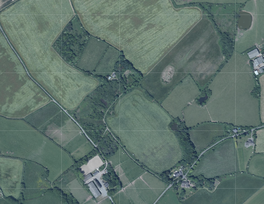
Aerial site location map showing a rural plot surrounded by fields, hedgerows, and nearby buildings.
1.0 Introduction
1.1 The site is a holding of approximately 11 acres which is located on the northern side of the Ballacorey Road (C15) which links the Bride Coast Road (A10) with the Andreas Road (A9).
1.2 The holding accommodates some existing buildings including an existing occupied dwelling (Ballasleig Croft), a former dwelling (Sycamore Cottage) which has planning approval for replacement with a dwelling, which is understood to have commenced, and a small outbuilding with timber shed behind.
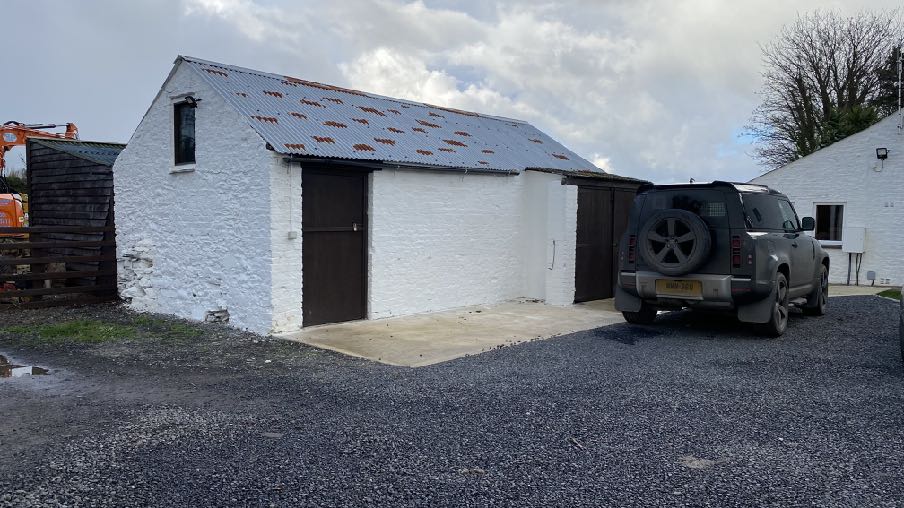
Small outbuilding and timber shed behind
A photograph showing a white single-story outbuilding with a corrugated roof and a car parked on a gravel driveway, with construction machinery visible to the left.
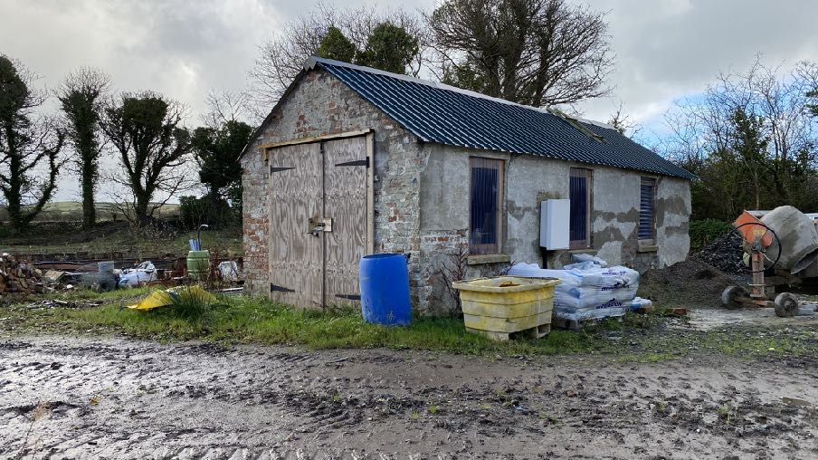
Former cottage (Sycamore Cottage) approved to be replaced by a dwelling
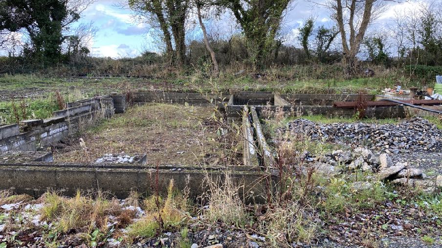
Existing footings for approved replacement building
A photograph of a stone outbuilding or barn undergoing renovation, featuring large wooden doors and construction materials like a cement mixer nearby.A photograph showing the concrete foundations of a demolished structure in an overgrown, rural setting, likely the site for the proposed replacement dwelling.
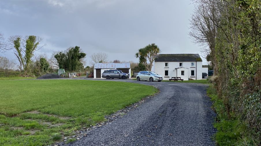
Ballasleig Croft with outbuilding to the left
1.3 The site some way from the public highway and along a winding private lane which renders the existing buildings incapable of being seen by the public.
2.0 THE PROPOSAL
2.1 Proposed is the erection of a dwelling to replace the existing former cottage which will be demolished in due course. This is a resubmission and modification to the extant approval under 06/01821/B which has commenced - see photograph of footings and former cottage below.
2.2 The application proposes the erection of a new house which has a slightly longer frontage than that which has approval (12.4m compared with 11.5m), a similar depth of building (5.5m compared with 5.35m), an almost identically sized rear projection. The new proposal includes a small side annex to provide a utility room which then accesses the kitchen, enabling people to have somewhere to take off dirty footwear and outside coats, before entering into the main house or using the main front entrance together with equipment and installations associated with the Air Source and renewable energy systems.
2.3 There is also to be a single storey flat roofed annex to provide a living area on the ground floor as well as a ground floor en suite bath room for guests or occupants who are incapable of using the stairs.
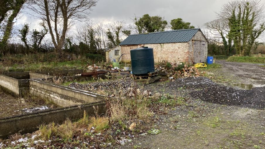
A photograph of a rural site featuring concrete drainage beds in the foreground, a large blue water tank, and a stone outbuilding with a dark roof in the background.
2.4 The overall proposed floor area, measured externally, is 246 sq m compared with 190 sq m plus the porch footprint as permitted due mainly to the inclusion of the rear utility room and rear single storey annex. It should be noted that there were no conditions attached to the 2006 application which would have prevented an extension being erected under Permitted Development and at that time we understand it would have been possible to erect a further glazed extension up to 12 sq m in area without permission - which has since been extended to 15 sq and is currently proposed (in a Departmental consultation document on the revision of the the Town and Country Planning (Permitted Development) Order 2012) to be increased to up to 35 sq m subject to certain conditions.
2.5 The appearance of the proposed dwelling has also changed slightly, the additional 1m frontage now being balanced by a slightly wider porch whose apex runs parallel with the ridge and eaves of the front section of the house, more consistent with the horizontal orientation and traditional proportions and form of the principal elevation.
2.6 There is no longer an external staircase, which we did not feel was overly traditional on a dwelling and the chimney has been removed from the rear annex which we did not feel was necessary and is not referred to or shown in the Residential Design Guide (Planning Circular 3/91).
2.7 The dwelling is also to be slightly resited such that there is a slight overlap with the approved footprint but it is closer to the location of the building which is to be replaced and further from the existing trees to the south. Most importantly, the dwelling is now oriented so that it has an increased exposure to a more open south westerly aspect which will maximise the solar gain to the property, both in terms of natural light and heat through the glazing but most importantly, to the proposed solar panels which are intended to be installed within the largest expanse of roofing.
2.8 There is no change to the access to the site, the residential curtilage or means of drainage, all of which are to be as originally proposed and approved.
3.0 Planning policy
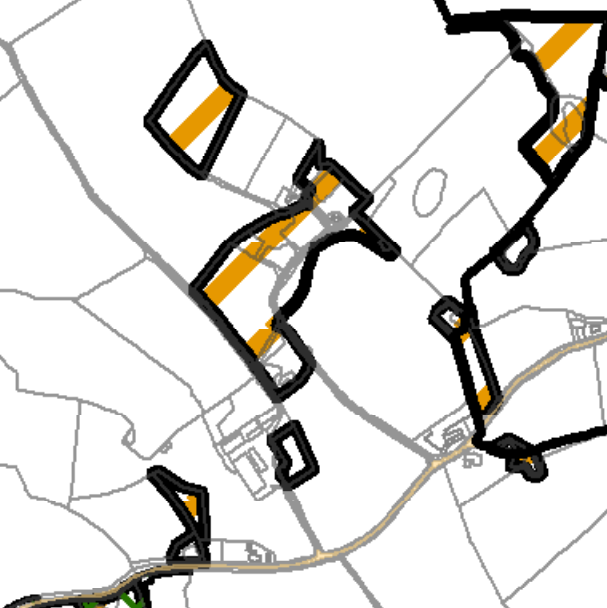
3.1 The starting point for the determination of any planning application is the land use designation in the relevant adopted development plan. In this case this is the Isle of Man Planning Scheme (Development Plan) Order 1982 although this is in the process of being updated by the Area Plan for the North and West. On the 1982 Plan (below) the site is within an area not designated for a particular purpose and not part of an area of an area of High Landscape or Coastal Value and Scenic Significance.
3.2 In this part of the Island, the Isle of Man Planning Scheme (Development Plan) Order 1982 is being replaced by a new Area Plan (for the North and West). This is currently in draft form, although was the subject of a public inquiry in July 2024 with the inspector’s report having been received in October, 2024 and published in November 2024, so has only limited weight, but confirms the designation of the site as not for any particular purpose. This also has maps which show specific constraints, including the Environmental Constraints and Infrastructure constraints. The Environmental Constraints Map shows the central area where the buildings are located including the site of the proposed new dwelling, as of Ecological Interest.
A map showing rural land parcels with thick black outlines and orange highlights, likely indicating a site location or boundary plan.
3.3 There are no Infrastructural Constraints shown on the relevant map and the site is not shown on the national flood risk maps as being at risk of flooding although close to an area shown as being at risk of surface water flooding.
3.4 Trees are generally protected under the Isle of Man Strategic Plan Environment Policy 3 although there are no Registered Trees on the holding.
3.5 Ecology is protected under Environment Policies 4 and 7. The site is not designated as of ecological importance (see above).
3.6 There is a general presumption against development in undesignated areas, as set out in General Policy 3 of the Strategic Plan (see Appendix One). Environment Policy 1 presumes against development which would be harmful to the character and appearance of the countryside.
3.7 This site lies within an area on the Landscape Character Assessment as part of a large area of Undulating Lowland Plain (F3). The full advice on this type of area is set out in Appendix Two with the most relevant parts highlighted. The draft Area Plan summarises this
as follows with a relevant Landscape Proposal:
6.4.3 The Undulating Lowland Plain of Andreas and Jurby (F3) encompasses a swathe of farmland underlain by the predominantly flat topography of the northern plain. To the west, the narrow course of the Lhen trench meanders through the landscape. The main A19 and A17 roads cross the area interlinking with a network of minor roads often lined with tall Manx sod banks. Settlement pattern is scattered and relatively isolated with the Andreas and Jurby Industrial Estates and IOM prison providing the largest groups of buildings within the area. Overall, there is a strong sense of tranquillity and openness. A strong recognisable sense of place is provided by views to the dramatic backdrop of the Uplands to the south, views of St. Patrick’s Church and distant views to the sea
at the eastern and western edges of the area.
Landscape Strategy To conserve and enhance: a) the character, quality and distinctiveness of this rural area including the scattered settlement pattern, relatively strong field pattern delineated by a mixture of stone walls and relatively tall Manx hedge-banks and its network of enclosed minor rural roads
Key Views - Glimpsed views to the sea from the eastern and western edges of the area. Panoramic open views southwards towards a dramatic upland backdrop. Open views to landmark church towers (particularly St. Patrick’s Church) to the west of Jurby.
3.8 Whilst there is a presumption against development in this area according to General Policy 3 pf the Strategic Plan, there is provision for the erection of buildings to replace existing dwellings (General Policy 3d and Housing Policies 12 and 14).
3.9 The highest quality agricultural land (Classes 1 -2 including 2/3 and 3/2) will be protected from development (Environment Policy 14). The soil here is Class 3/2.
3.10 Development is expected to comply with the general standards set out in General Policy 2 of the Strategic Plan:
General Policy 2: Development which is in accordance with the land-use zoning and proposals in the appropriate Area Plan and with other policies of this Strategic Plan will normally be permitted, provided that the development:
(a) is in accordance with the design brief in the Area Plan where there is such a brief;
(b) respects the site and surroundings in terms of the siting, layout, scale, form, design and landscaping of buildings and the spaces around them;
(c) does not affect adversely the character of the surrounding landscape or townscape;
(d) does not adversely affect the protected wildlife or locally important habitats on the site or adjacent land, including water courses;
(e) does not affect adversely public views of the sea;
(f) incorporates where possible existing topography and landscape features, particularly trees and sod banks;
(g) does not affect adversely the amenity of local residents or the character of the locality;
(h) provides satisfactory amenity standards in itself, including where appropriate safe and convenient access for all highway users, together with adequate parking, servicing and manoeuvring space;
(i) does not have an unacceptable effect on road safety or traffic flows on the local highways;
(j) can be provided with all necessary services;
(k) does not prejudice the use or development of adjoining land in accordance with the appropriate Area Plan;
(l) is not on contaminated land or subject to unreasonable risk of erosion or flooding;
(m) takes account of community and personal safety and security in the design of buildings and the spaces around them; and
(n) is designed having due regard to best practice in reducing energy consumption.
4.0 Planning history
4.1 The site has been the subject of a number of applications concerning the cottage and the former barn on the site and also for proposed new buildings.
4.2 09/01607/B proposed the erection of two timber agricultural buildings: these were to be 10m by 15m and 25m by 15m respectively and the application was refused for the reasons that it had not been demonstrated that there was sufficient agricultural need to override the presumption against development here and noting that the site did not represent a viable agricultural holding due to its size and also the amount of trees which would be lost to facilitate the new buildings would result in an adverse impact on the landscape.
4.3 A contemporaneous application for alterations and extension of the existing cottage was also refused. 09/01601/B proposed a significant two storey extension to the cottage which was refused for the reason that the size and design would detract from and not respect the traditional character of the property, and thus fail Housing Policy 15.
4.4 A series of applications saw approval granted for the replacement of the former cottage to the east of Ballasleig Croft: 99/02218/A was approved in principle with 00/00790/B refused initially but permitted on review (no details are available online). However, a subsequent application, 06/01821/B was approved providing the details of the replacement house. It is understood that this permission has commenced and may continue to completion.
5.0 Assessment
5.1 The site lies within an area which is not designated for development but the Strategic Plan makes it clear that development which involves the replacement of existing buildings, including existing dwellings, is permissible under certain conditions: indeed planning approval was granted for a new dwelling to replace the existing former cottage, which remains, and work commenced upon that approval.
5.2 We would submit that nothing has changed in policy or circumstance since then and as such, the starting point should be that the principle of the replacement of the existing outbuilding remains and that a house of approximately 190 sq m with provision for extensions under the Permitted Development Order as applicable to that permitted scheme, is acceptable.
5.3 What is now proposed, we would submit, is more sympathetic to the site and is in closer conformity with current policy in respect of a number of elements:
• It is to be sited closer to the building which it replaces, thus being in closer conformity with Housing Policy 14 which reflects current adopted policy which was not in place at the time of the 2006 approval.
• It is sited further from existing trees which we understand support the ecological interest identified in the draft Area Plan for the North and West, not only in terms of the construction of the building but also its future life and occupation as the trees around it grow taller and wider.
• The orientation will maximise natural light and heat and the efficacy of solar panels.
• The house will need to be constructed in accordance with current Building Regulation standards which are considerably higher in terms of thermal efficiency and renewable energy than was the case with the extant permission.
• The design is more traditional than the building which it is replacing, in accordance with Housing Policy 14 in respect of larger replacement buildings.
5.4 The proposed development will have no greater impact on the environment than what has approval, arguably less given the environmental benefits listed above. The proposed dwelling will be a crisper, more modern interpretation of the traditional Manx cottage whilst retaining most of the elements referred to in the Residential Design Guide of 1991 which remains the guidance for rural dwellings.
5.5 Whilst the soil is generally considered to be good quality, the residential curtilage of the proposed dwelling is as approved and capable of use as such under the 2006 extant approval. The land in this part of the site is not used for agricultural purposes nor particularly well placed or sized for such use. It is presently disturbed ground which is partly used for material storage and, we would submit, not of any particular ecological or agricultural value.
5.6 The proposal will incorporate ecologically beneficial features such as reinforcement planting of local trees and shrubs and where appropriate, nest boxes for birds and bats: as no habitat is being removed as part of the approval, given the extant permission, it is not expected that this will or should be required by condition but the applicant is happy to seek advice following any approval of this application, to install a range of ecologically supportive features as shown generally on the drawings.
5.7 The nature of construction has changed significantly since the first approval of the replacement of Sycamore Cottage: for example, heating and energy systems which are now electricity based and designed to accommodate renewable generation involve more equipment and installations including large storage cylinders and as such require more space in utility areas than would systems have done in the past. The addition of the utility room is therefore warranted given this change in technology and a requirement through changes to the Building Regulations.
5.8 This application will enable the completion of a long standing development which is presently contributing little, if anything to the environment and will allow the occupation, management of and investment in an attractive new, thermally efficient dwelling sited to maximise renewable energy, supporting the Climate Change objectives and satisfying the majority of the relevant planning policies.
Sarah Corlett 22.11.2024
Appendix One - policies
Strategic Plan
General Policy 3: Development will not be permitted outside of those areas which are zoned for development on the appropriate Area Plan with the exception of:
(a) essential housing for agricultural workers who have to live close to their place of work; (Housing Policies 7, 8, 9 and 10);
(b) conversion of redundant rural buildings which are of architectural, historic, or social value and interest; (Housing Policy 11);
(c) previously developed land(1) which contains a significant amount of building; where the continued use is redundant; where redevelopment would reduce the impact of the current situation on the landscape or the wider environment; and where the development proposed would result in improvements to the landscape or wider environment;
(d) the replacement of existing rural dwellings; (Housing Policies 12, 13 and 14);
(e) location-dependent development in connection with the working of minerals or the provision of necessary services;
(f) building and engineering operations which are essential for the conduct of agriculture or forestry; (g) development recognised to be of overriding national need in land use planning terms and for which there is no reasonable and acceptable alternative; and
(h) buildings or works required for interpretation of the countryside, its wildlife or heritage.
Environment Policy 1: The countryside and its ecology will be protected for its own sake. For the purposes of this policy, the countryside comprises all land which is outside the settlements defined in Appendix 3 at A.3.6 or which is not designated for future development on an Area Plan. Development which would adversely affect the countryside will not be permitted unless there is an over-riding national need in land use planning terms which outweighs the requirement to protect these areas and for which there is no reasonable and acceptable alternative.
Environment Policy 3: Development will not be permitted where it would result in the unacceptable loss of or damage to woodland areas, especially ancient, natural and seminatural woodlands, which have public amenity or conservation value.
Environment Policy 4: Development will not be permitted which would adversely affect:
(a) species and habitats of international importance:
(i) protected species of international importance or their habitats; or
(ii) proposed or designated Ramsar and Emerald Sites or other internationally important sites.
(b) species and habitats of national importance:
(i) protected species of national importance or their habitats;
(ii) proposed or designated National Nature Reserves, or Areas of Special Scientific Interest; or
(iii) Marine Nature Reserves; or
(iv) National Trust Land.
(c) species and habitats of local importance such as Wildlife Sites, local nature reserves, priority habitats or species identified in any Manx Biodiversity Action Plan which do not already benefit from statutory protection, Areas of Special Protection and Bird Sanctuaries and landscape features of importance to wild flora and fauna by reason of their continuous nature or function as a corridor between habitats.
Some areas to which this policy applies are identified as Areas of Ecological Importance or Interest on extant Local or Area Plans, but others, whose importance was not evident at the time of the adoption of the relevant Local or Area Plan, are not, particularly where that plan has been in place for many years. In these circumstances, the Department will seek site specific advice from the Department of Agriculture, Fisheries and Forestry if development proposals are brought forward.
Environment Policy 14: Development which would result in the permanent loss of important and versatile agricultural land (Classes 1-2) will not be permitted except where there is an overriding need for the development, and land of a lower quality is not available and other policies in this plan are complied with. This policy will be applied to
(a) land annotated as Classes 1/2 on the Agricultural Land Use Capability Map; and
(b) Class 2 soils falling within areas annotated as Class 2/3 and Class 3/2 on the Agricultural Land Use Capability Map.
Housing Policy 12: The replacement of an existing dwelling in the countryside will generally be permitted unless:
(a) the existing building has lost its residential use by abandonment; or
(b) the existing dwelling is of architectural or historic interest and is capable of renovation. In assessing whether a property has lost its habitable status(1) by abandonment, regard will be had to the following criteria:
(i) the structural condition of the building;
(ii) the period of non-residential use(2) or non-use in excess of ten years;
(iii) evidence of intervening use; and
(iv) evidence of intention, or otherwise, to abandon.
Housing Policy 14: Where a replacement dwelling is permitted, it must not be substantially different to the existing in terms of siting and size, unless changes of siting or size would result in an overall environmental improvement; the new building should therefore generally be sited on the “footprint” of the existing, and should have a floor area(1), which is not more than 50% greater than that of the original building (floor areas should be measured externally and should not include attic space or outbuildings). Generally, the design of the new building should be in accordance with Policies 2- 7 of the present Planning Circular 3/91, (which will be revised and issued as a Planning Policy Statement).
Exceptionally, permission may be granted for buildings of innovative, modern design where this is of high quality and would not result in adverse visual impact; designs should incorporate the re-use of such stone and slate as are still in place on the site, and in general, new fabric should be finished to match the materials of the original building.
Consideration may be given to proposals which result in a larger dwelling where this involves the replacement of an existing dwelling of poor form with one of more traditional character, or where, by its design or siting, there would be less visual impact.
Appendix Two
Landscape Character Assessment
F3 ANDREAS AND JURBY Key Characteristics
• Swathe of farmland (covering the breadth of the Island).
• Irregular pattern of medium-sized arable and pasture fields.
• Field boundaries demarcated by traditional Manx hedges and simple post and wire fences.
• Inter-linking network of minor rural roads serve the area, together with the A10, A17 and A19.
• Generally few vertical elements, other than occasional telegraph poles.
• Scattered and relatively isolated settlement pattern.
• Traditional farm buildings (characteristically white, with grey roofs).
• Key settlements include the small town of Andreas and the villages of Bride, Jurby and Sandygate.
• The Isle of Man Government Industrial Estate and adjacent Jurby Aerodrome
• Disused airfield at Andreas
• Churches provide prominent landmarks within views.
• Views to dramatic upland backdrop to the south provide strong sense of place.
• Strong sense of openness and tranquillity (at distance from main A19 and A17 roads).
• Slightly marked sinuous valley of Lhen Trench.
• Sandpit at Cronk-y-Scotty
Overall Character Description Situated to the north of the Island, this landscape character area encompasses a swathe of farmland underlain by the predominantly flat topography of the northern plain. To the west, the relatively narrow course of the Lhen trench meanders through the landscape, which exhibits an irregular pattern of medium-sized arable fields and rough grassland/pasture. A variety of different forms of hedgerows and simple post and wire fences demarcate field boundaries. To the west, mature, intact low, trimmed hedges dominate the hedgerow network. Several single mature deciduous trees within Manx hedgerows and fields also contribute to a mature recognisable landscape structure. The main A19 and A17 roads (a source of noise and visual intrusion) cross the area and an inter-linking network of minor roads, often lined with species-rich verges, help to provide access to farms and settlements. Generally, few vertical elements punctuate the skyline of the area. However, telegraph poles and the telecommunications mast at Jurby Industrial Estate are a visible human influence. Settlement pattern is scattered and relatively isolated, with the Andreas and Jurby Industrial Estates providing the largest groups of buildings within the area. Several isolated farmsteads
and individual houses also pepper the landscape. Traditional farm buildings characteristically exhibit white walls (which often provide a bright contrast to the muted upland backdrop to the north) and grey roofs. Alongside these traditional buildings, modern agricultural sheds and warehouses are sometimes visually intrusive. In addition, the distinctive churches of St. Andrews Church at Andreas (built predominantly from Sulby Glen stone) and St. Patrick’s Church to the west of Jurby and their associated medieval crosses are landmark features landscapes within the area. St. Patrick’s Church is particularly prominent within views across the surrounding open, flat landscape. The prefabricated buildings on an old air force base and disused runway at Jurby (now housing several small businesses and shops, including Jurby Junk) exhibit a strong human influence over the character of this part of the area. Construction of the new prison development is also associated with this part of the area. Overall, there is a strong sense of tranquillity and openness throughout the area. A strong recognisable sense of place is provided by views to the dramatic backdrop of the Uplands to the south, views of St. Patrick’s Church and distant views to the sea at the eastern and western edges of the area.
Key Views
• Glimpsed views to the sea from the eastern and western edges of the area.
• Panoramic open views southwards towards a dramatic upland backdrop.
• Open views to landmark church towers (particularly St. Patrick’s Church) to the west of Jurby.
Historic Features
• St. Patrick’s Church and medieval crosses.
• St. Andrew’s Church and medieval crosses.
• Old airfields at Jurby and to the east of Andreas.
Ecological Features
• Species-rich verges.
• Mature hedgerows and single mature deciduous trees.
• Patches of rough grassland
• Area of Special Scientific Interest at Ballacrye
Evaluation of Inherent Landscape Sensitivities
• Strong sense of tranquillity.
• Scattered isolated settlement pattern.
• Enclosed minor rural roads.
• Vernacular character of buildings and churches.
• Presence of Manx Mile stones.
• Few tall vertical elements.
• Dramatic views south to Uplands.
• Field pattern delineated by a mixture of stone walls, relatively tall Manx hedge-banks and post and wire fences.
Landscape Strategy The overall strategy should be to conserve and enhance the character, quality and distinctiveness of this rural area including the scattered settlement pattern, relatively strong field pattern delineated by a mixture of stone walls and relatively tall Manx hedge-banks and its network of enclosed minor rural roads.
Copyright in submitted documents remains with their authors. Request removal