Approval in Principle for Residential Development,
Land adjacent to Existing Residential Areas of Trollaby
Lane, Strang Road and Main Road, Union Mills
Dandara Homes Limited, Isle of Man Buisness Park, Cooil Road, Braddan, Isle of Man IM2 2SA
Introduction
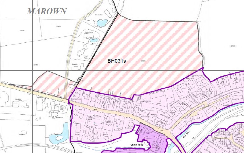
1. The site which forms the subject of this planning application is located on the north western side of Union Mills village, and forms part of the wider area known as Camlork. The site is identified in the Area Plan for the East as a Residential Strategic Reserve. This application seeks Planning Approval in Principle to develop the site for residential purposes.
2. The granting of Planning Approval in Principle will allow the site to be brought forward for residential development, which will;
Help to ensure continuity of housing supply in the East of the Island, including affordable housing;
Help to facilitate the growth of the Island’s population in accordance with the Government’s Economic Strategy;
Provide an opportunity to meet local housing need and “broaden the choice of location of housing” in Union Mills;
Establish the southern end of a potential highway link between Peel Road and Mount Rule Road which, subject to future land use zonings, would improve access to Nobles Hospital and reduce the need for vehicles to use Strang Road.
3. Upon the granting of planning approval (in principal and, subsequently, reserved matters) the site would be available for development immediately. It would represent a sustainable extension to an existing residential area and would be adjacent to the existing settlement boundary of Union Mills. The Site
4. The area which has historically been known as Camlork (it is part of the wider holding of Camlork Farm) comprises approximately 20 hectares to the north of Strang Road, west of Mount Rule Road and north of Peel Road. The land which forms the subject of this planning application is located at the western end of that area and consists of field 521518, part of field 324213 and an area between the two which contains an unnumbered parcel of land, part of the
Trollaby River and part of Trollaby Lane. The site area is approximately 5.73 ha.
5. Both field 521518 and field 324213 are used for agricultural grazing, with field 521518 enclosed by existing development on two sides – the housing of Trollaby Lane to the west, and the housing of Main Road and Strang Road to the south. The employment area known as Corlett Sons & Cowley Yard also adjoins part of the southern site boundary.
6. Manx hedges interspersed with trees exist at the site boundaries, including that between field 324213 and Peel Road. Mature trees are located at the western boundary between field 521518 and the dwellings on Trollaby Lane. Policy Context
7. The Isle of Man Strategic Plan; the Isle of Man Strategic Plan (IoMSP) was first adopted by the Department in June 2007 and approved by Tynwald the following month, and is intended to provide “the strategic and general policy framework within which provision will be made for development and conservation needs for the period 2001-2016”. Together with Area Plans the IoMSP forms a Development Plan as required by the 1999 Town and Country Planning Act. It is explained in the IoMSP that existing Local Plans will remain in effect until they are replaced by new Area Plans, and that the 1982 Development Plan, as amended by the various Local Plans, will have effect as an Area Plan. It is also made clear in the Plan that “in the case of any inconsistency between the provisions of the Strategic Plan and the provisions of an Area Plan, whichever came into force later will prevail”. The Isle of Man Strategic Plan 2016, which contains updated population statistics and housing policies for the period 2011 to 2026, was approved by Tynwald in March 2016.
8. Amongst other things the Strategic Objectives of the Plan (pages 11-12) seek to promote efficiency and economy in the protection, use, and re-use of resources, and they indicate that most new development should be guided towards existing settlements in order to make “the optimum use of existing
and planned infrastructure and services”. They also seek to protect, maintain and enhance the built and rural environment, to encourage high quality development throughout the Island, and to ensure that new development relates well to public transport facilities. The Plan also includes Strategic Objectives which state that the housing needs of the community should be met by the provision of sufficient housing of an acceptable standard and of an appropriate nature and in appropriate locations, and that high standards of residential amenity in new development and a physically safe environment will be promoted.
9. The Strategic Policies which flow from these objectives (pages 14-19) emphasize the need to make the best use of resources by “optimising the use of previously developed land, redundant buildings, unused and under-used land and buildings, and re-using scarce indigenous building materials”, by “ensuring efficient use of sites, taking into account the needs for access, landscaping, open space, and amenity standards” and “being located so as to utilise existing and planned infrastructure, facilities and services”. New development will be located primarily within existing settlements or within sustainable urban extensions (with identified exceptions for development in the countryside), and should be designed so as not to detract from the character of towns and villages. New development, including individual buildings, should be designed so as to make a positive contribution to the environment of the Island and in appropriate cases the Department will require planning applications to be supported by a design statement. Tourist development proposals will generally be permitted where they make use of existing built fabric of interest and quality, and it is stated that new development should be located and designed so as to promote a more integrated transport network.
10. The IoMSP includes an Island Spatial Strategy (ISS, pages 20-29) which is intended to guide the physical development of the Island up to 2016 (although given that the Plan’s housing figures have been revised it can be assumed that whole Plan is to be considered relevant to the period 2011-2026). The
Island is divided into North, South, East and West regions and the ISS seeks to “promote a balanced and equitable pattern of sustainable development across the Island”. Union Mills is identified at Spatial Policy 3 (page 26) as a Service Village which will “provide regeneration and choice of location for housing, employment and services”. SP3 goes on to state that “Area Plans will define the development boundaries of such villages so as to maintain and where appropriate increase employment opportunities. Housing should be provided to meet local needs and in appropriate cases to broaden the choice of location of housing.”
11. It is estimated in the ISS that in order to meet the housing needs of the Island over the revised plan period (2011-2026) provision will have to be made for the development of 5,100 additional dwellings, and the Plan indicates that the Island’s eastern region – which is comprised of Douglas, Onchan, Braddan, Marown, Santon, Laxey & Lonan – will accommodate 2440 of those dwellings. The most recent Residential Land Availability report (Update 17, published May 2024) indicates that, when projected windfalls and conversions are taken into account, the number of units required to meet housing need in the east for the revised plan period (2011-2026) currently stands at 1703.
12. Chapter 6 of the Plan is entitled General Development Considerations, and it is made clear in the introduction that the Development Plan “will make positive land-use allocations and provision through its policies such as to meet the Island’s foreseen development needs for the period 2001-2016”. Again, given that the Plan’s housing figures have been revised it can be assumed that the whole Plan is to be considered relevant to the period 2011-2026. The Plan will therefore provide the basis upon which development control decisions are made during this period, with General Policy 1 (page 32) confirming that the determination of such shall have regard to the provisions of the Development Plan and all other material considerations. General Policy 2 of the Plan (pages 32-33) identifies broad standards of development to be taken into account if proposals are to be permitted, which include criteria in respect of building siting, layout, form and appearance, impact upon landscape or townscape,
amenity standards for residents, highway safety and traffic flows, and parking space provision. Transport Policy 7 (page 101) requires parking provision in all new development to meet the Department’s standards, which is shown at Appendix 7 of the IoMSP (page 139) to be 2 spaces per unit for typical residential and terrace development. General Policy 3 (page 33) indicates that development will not be permitted outside of areas which are zoned for development unless it accords with one of the listed exceptions.
13. Environment Policy 1 (page 38) states that the countryside, which does not include land which is designated for future development on an Area Plan, will be protected for its own sake. Subsequent policies in respect of the Rural Environment seek to ensure that development will not have an adverse effect upon landscape character, woodland, areas of ecological interest, watercourses, the coastal environment, areas affected by erosion or flooding, or important agricultural land. Environment Policy 16 (page 48) states that the use of existing rural buildings for new purposes such as tourist use may be permitted where, amongst other things, it is demonstrated that the building is no longer required for its original purpose and where the building is substantially intact and structurally capable of renovation, and where the reuse of the building will result in the preservation of fabric which is of interest or attraction. Environment Policy 42 (page 58) requires the design of new development in existing settlements to take account of “the particular character and identity, in terms of buildings and landscape features, of the immediate locality”.
14. Within the Housing chapter of the Plan it is explained that “The Area Plans will need to ensure that there is enough flexibility to react to pressures relating to both supply and demand. Site allocations known as Strategic Reserves are likely to be used in the Area Plans for this very purpose. The Area Plan for the South identified two Strategic Reserve sites for housing. The difference between the Reserve Sites and general allocations is that the Reserve Sites are not for immediate release. They will only be released when the Department is certain that there is a need for them and a defined methodology
included within the Area Plan has been followed. All Reserve Sites will have specific development briefs set out in the Area Plans. This approach is being monitored but is one likely to be adopted across the Isle of Man for the remaining Area Plans to ensure that sufficient opportunities are available for housing. The use of such ‘reserve’ allocations demonstrates the ‘Plan, Monitor and Manage’ approach advocated by this Plan”.
15. Housing Policy 1 (page 67) states that provision will be made for up to 5,100 additional dwellings over the period of the Plan, which will be subject to a “Plan, Monitor and Manage” approach by the Department. Housing Policy 2 (page 67) states that the Department will seek to ensure an adequate supply of housing land, and goes on to suggest that designated land which is not made available for development could be placed in a land-bank and alternative land allocated for development in its place. Housing Policy 3 (page
69) confirms the distribution of dwellings suggested by the ISS, and Housing Policy 4 (page 69) states that housing should primarily be located within existing settlements or within sustainable urban extensions.
16. Housing Policy 5 (page 70) indicates that the Department, when granting planning permission on land which is zoned for residential development or in predominantly residential areas, will normally require that 25% of new dwellings on sites of 8 or more units will be affordable. The supporting text outlines the factors to which the Department will have regard when assessing the appropriate percentage in each instance.
17. Recreation Policy 3 (page 91) states that, where appropriate, new development should incorporate landscaped amenity areas into the design and that new residential schemes of ten or more dwellings must make provision for recreation and amenity space in accordance with the standards specified at Appendix 6 of the Plan. The Plan makes it clear that the general standards of space provision set down for new residential development will be applied having regard to criteria such as the size, type and particular needs of the resident population, the needs of visitors to the area and the proximity and
availability of existing Open Space, including the foreshore, public glens and parks.
18. Appendix 6 of the Plan (pages 132-136) provides guidance in respect of open space requirements for new residential development, and confirms that the exact open space requirement will depend upon the individual circumstances and nature of each planning application. It goes on to differentiate between “open space” and “outdoor playing space”, confirming that the latter may include sports and recreation facilities that are designed to serve the needs of either the general public or the members of a private organisation. It may also include formal or informal areas which are designed for children’s play, but excludes areas such as woodlands and golf courses. The Plan sets the overall open space standard at 32 sq.m for each new resident, which is broken down further into 18 sq.m of formal space such as sports pitches, 6 sq.m of children’s play space and 8 sq.m of amenity space. It also sets the assumed occupancy levels for new dwellings, and explains that where possible open space should be provided in the first instance on-site or off-site where this would improve the quality of the development and the open space provided. Where these options are not practical then commuted sums will be considered.
19. Transport Policies 1 and 2 (pages 99 & 100) require new development to be located, where possible, close to existing public transport facilities and routes, including pedestrian, cycle and rail routes, and where appropriate to make provision for new routes including links into existing systems. Transport Policy 4 of the Plan (page 100) seeks to ensure that new and existing highways are capable of safely accommodating the vehicle and pedestrian journeys created by development, Transport Policy 7 refers to parking standards (see above) whilst Transport Policy 8 (page 102) requires all applications for major development to be accompanied by a Transport Assessment.
20. Infrastructure Policy 1 (page 105) states that development shall only take place in areas that will ultimately be connected to IRIS, whilst Infrastructure Policy 2 (page 105) states that interim drainage arrangements for
development in areas awaiting connection to IRIS shall be submitted to and approved by the Department. Energy Policy 5 (page 113) requires proposals for more than 5 dwellings to be accompanied by an Energy Impact Assessment .
21. The Area Plan for the East; the Town and Country Planning (Area Plan for the East) Order 2020 was approved by Tynwald on 18th November, 2020 and came into operation on 1st December, 2020. The role of the Plan “is to set out locally appropriate ways of managing and guiding development based on the broad approaches approved to satisfy social, economic and environmental needs. The Plan is a material consideration for decision makers when determining planning applications for as long as it remains in operation”. As well as allocating specific uses to land in the East of the Island the APE provides Proposals and Recommendations which are intended to guide the development or protection of land and sites within the Plan area. Sites which are allocated in the APE for future development are referred to as “Proposal Sites” or “Strategic Reserves”.
22. It is explained in the Area Plan that the Isle of Man Strategic Plan 2016 covers the period from 2011 to 2026, and that the APE matches this period, as it represents the implementation of the strategic policies. It recognises that the Strategic Plan is due for review, which would be best undertaken with the benefit of the findings of a full census (which subsequently took place in 2021).
23. Whilst the APE will not formally extend beyond the end of the Strategic Plan ‘plan period’ (31st March 2026), the lifetime of the Plan and relevance of the Proposals within the Plan will not come to an end at that point. It is made clear that the Plan will continue in operation until it is replaced, citing the need for continuity and for any transition from one statutory plan to another to take place smoothly and without ambiguity. The stated intention is to review the APE as part of an all-Island Area Plan process which will take place alongside a full review of the Strategic Plan.
24. The Plan goes on to state that “In the meantime, in addition to land allocated for immediate development, the Area Plan contains some ‘Strategic Reserve Sites’, which identify land for future residential development, should this be required. Until these sites are released for development, they will be subject to General Policy 3 of the Strategic Plan”.
25. The sites which are identified as Strategic Reserves (SR) are considered at Chapter 12 of the Plan, which includes details of a SR release mechanism. It also provides Development Briefs for the SR sites, which are included to provide additional guidance to support the decision making process on planning applications. Development briefs provide direction on the expected use, design, layout and infrastructure requirements to be included in and addressed as part of development proposals, but are not intended to be exhaustive nor replace the requirements of the Isle of Man Strategic Plan. They are intended to guide:
proposers drafting planning applications;
the public and interested parties in understanding what to expect on a site allocated in the Plan; and
decision makers in assessing the merits of an application and how proposals comply with guidance set out in the Plan.
26. Chapter 12 also provides a summary of the Plan’s position on housing need;
The housing need calculations in the Strategic Plan are based on a projected Island-wide population, living in private households, of 91,898 by 2026. This assumed net inward migration of 500 people a year between 2011 and 2026,
With an average household size of 2.27 persons, this indicated that there would be 40,484 resident households on the Isle of Man by 2026.
At the time of the 2011 Census there were 35,599 resident households in the Isle of Man, so there was expected to be an increase of 4,885 households between 2011 and 2026. After allowing for vacancies and
rounding, this resulted in a total housing requirement of 5,100 additional dwellings for the period 2011 to 2026, as set out in Housing Policy 1 of the Strategic Plan. Assuming that 48% of these dwellings would be needed in the East, the housing requirement for the East was for 2,440 additional dwellings, as set out in Housing Policy 3 of the Strategic Plan.
A more recent projection based on the results of the 2016 Census, and assuming net inward migration of 500 people a year between 2016 and 2026, shows that by the end of that period, there would be an Islandwide population of 85,671 living in private households.
With an average household size of 2.24 persons, this indicates that there would be 38,317 households on the Isle of Man by 2026.
Whereas the Strategic Plan assumed an increase of 4,885 resident households between 2011 and 2026, the later projection points to a smaller increase of 2,718 households during that period.
The Strategic Plan assumes that 48% of the additional households would live in the East. On that assumption, there would be 1,358 additional households in the East between 2011 and 2026.
In order to provide some flexibility, and allow for the possibility that some allocated sites might not be brought forward for development, it would be prudent to make provision for some 1,500 additional dwellings in the East during this period.
27. The Plan goes on to suggest that the allocated Residential Proposal Sites and Strategic Reserve Sites, along with existing supply and projected housing numbers via conversions, can provide for 2,440 additional dwellings being delivered in the East between 2011 and 2026. When broken down further it is assumed that;
development completed or started between 2011 and mid-2018, the expected yield from outstanding approvals in mid-2018, and anticipated
conversions between 2018 and 2026, should provide more than 600 dwellings;
sites recommended for immediate development would provide space for more than 900 dwellings; and
Strategic Reserve Sites could be available for around 900 additional dwellings, should the need arise.
28. The Plan provides a summary of residential land provision;
29. In respect of Strategic Reserves the Plan sets out a number of “adopted principles”;
Cabinet Office has the decision making ability to formally release Strategic Reserve Sites although the Department of Environment, Food and Agriculture has the ability through the Town and Country Planning Act 1999 to determine any planning application made on a Strategic Reserve Site at any stage whether or not it has been formally ‘released’.
Data referred to in this section and the Strategic Reserve Release Mechanism (SRRM) Proposal has already been published and subjected to scrutiny through examination at Inquiry.
Strategic Reserves may be released individually by their site number, parts of which may be phased in any Cabinet Office Release Report as deemed appropriate.
Strategic Reserves may also be released alongside other numbered Strategic Reserves as part of a master-planned approach as set out in any Release Report.
Triggers for release of Strategic Reserves for predominantly residential use include statistical evidence on total resident population, residents living in private households and housing delivery in the plan area.
30. The data which underpins the Strategic Reserve Release Mechanism Proposals of the Plan (see below) is also outlined;
The Inquiry Report recommended “Strategic Reserve Sites will not be released for development until the population of the Isle of Man exceeds 89,000.” Based on the 2016 Interim Census and associated projections, an Island resident population of 89,000 would be reached by 2031 (using the assumption of 500 net migration pa). It would be reached sooner i.e. in 2022 if the Island witnessed a net migration of 1000 pa.
The housing need for the East (1,500) for the plan period using the 2016 Census was based on a total number of households in 2026 of 38,317.
In terms of what the plan should deliver at the end of the plan period
(2026), Table 18 at 12.15.3 under C – “Projected Conversions” and D “Allocated Sites” identifies that these should deliver 187 + 964 (1,151) dwellings by 31st March 2026, averaging 209 dwellings pa (averaged over 5.5 years) from Area Plan approval until 31st March 2026.
Housing delivery will be monitored using the Residential Land Availability Study (RLAS) Updates. RLAS 18 is expected to take into account the 2011 to 2025 data set.
Ultimately, Strategic Reserve site release will be based on settlement hierarchy and deliverability - taking into account all material considerations at the time - and may mean a mix of sites is brought forward and not necessarily the largest first.
A. A Strategic Reserve Site is land which may be suitable for development, but which will be held ‘in reserve’ until the need for such development has been established. The identification of Reserve Sites in this Plan allows for flexibility in land supply, should it be found that additional land is necessary. This accords with the ‘plan, monitor and manage’ approach identified in the Isle of Man Strategic Plan, and is necessary to ensure that the Plan can react to changing circumstances.
B. Strategic Reserve Sites in this Plan will not normally be released for development until the population of the Isle of Man exceeds 89,000.
C. However, Cabinet Office may, in the following circumstances, consider the release of Strategic Reserves for ‘predominantly residential’ use and make
public any such proposal to release a Strategic Reserve to a ‘general’ land allocation if:
i. a Government Census (or equivalent survey) states that the total number of private households is above 38,317; or
ii. the delivery of new housing from allocated sites and those projected from conversions represents a significant undersupply to that expected. When considering levels of delivery, Cabinet Office must have before it evidence on housing supply, corroborated by a published RLAS study. The first opportunity to consider release will be RLAS evidence which includes the dataset 2011 to
2025. This will allow a reasonable time for Cabinet Office to consider the merits of release, the publication of a decision, preparation of and determination of a planning application (by DEFA) and potentially the commencement of works, before the end of the plan period on 31st March
2026.
D. Prior to release of a Strategic Reserve site, Cabinet Office will consider all of the evidence and publish a Report. Reports may take into account the deliverability of sites including:
i. landowner/developer ability to comply with the principles of the development briefs set out in this Plan, and
ii. the willingness of the landowner/developer to pursue a planning application, develop-out the site, as well as any other material considerations relevant at that time.
E. Strategic Reserve Sites will normally be released in order of their position in the settlement hierarchy taking into account the circumstances evident at the time of any Cabinet Office Report, including the need for any supporting infrastructure. The order to be applied in respect of settlement hierarchy is as follows: 1st - Edge of Douglas sites (Main Centre)
• DM001s, DH002s, DH057s, DH010s, DH003s
• BH015s, BH019s
• DH008s 2nd - Edge of Onchan site (Service Centre)
• OH011s 3rd - Edge of Union Mills and Baldrine sites (Villages)
• BH031s
• GH013s
F. The status of all Strategic Reserve Sites will be reconsidered when this Area Plan is next reviewed and the broad merits of the release mechanism will be reviewed as part of any Strategic Plan Review.
32. Strategic Reserve Proposal 2 states;
The development of Strategic Reserve ‘Predominantly Residential’ Sites which may also include elements for community facilities such as schools will only be brought forward where it can be demonstrated:
i. that there is need for these sites which cannot be met by the existing allocations set out under Residential Proposal 1;
ii. that sufficient infrastructure exists, or can be provided prior to the development being brought into use, to allow the development to function and to avoid any unacceptable impact on wider networks;
iii. that the proposals will not have any unacceptable environmental impacts (including any significant landscape impacts); and
iv. All options for different uses on the sites have been fully explored taking into account health, social care and education needs.
33. The APE goes on to provide Development Briefs for the allocated SR sites, including the application site in this instance;
34. Other Guidance; further planning guidance is provided by a series of Circulars, Planning Policy Statements (most of which are Drafts) and Guidance Notes. Not all of the subjects are relevant in this instance – particularly as the application seeks Planning Approval in Principle – but guidance is available in respect of matters such as highways, trees, flood risk, economic issues, residential design, ecology and landscape character.
35. Relevant guidance in respect of wider Government objectives may also be provided by;
Our Island Plan (2022); essentially sets out the broad direction and overall ambition and vision for the Island from 2021 - 2026 with core strategic objectives to offer a 'secure', 'vibrant' and 'sustainable' Island.
Isle of Man Economic Strategy (2022); this highlights the economic strategy for taking the IoM forward through headwinds to 2032 and notes where greater investments are being made into the economic future.
Climate change action plan (2022-2027); this commits the Island to making significant changes to become more sustainable and less dependent on fossil fuels to become carbon neutral. This will impact upon the buildings, transport and business and how we use energy moving forward.
Built Environment Reform Programme (2022); BERP is a two year programme of work set out to develop commitments in the Island Plan to build great communities. The document also promotes brown field sites for regeneration and ways to stimulate development in the widest terms. (Strategic Objective 4)
Planning History
36. The site is currently zoned as a Strategic Reserve for residential development in the extant Area Plan for the East. As outlined above, the site is part of a wider area which is generally known as “Camlork”. The planning history of the wider Camlork site is detailed in the Inspector’s report for PA 07/00625/A, but in summary;
The whole of the site was allocated for Predominantly Residential use in the Isle of Man Planning Scheme (Development Plan) Order 1982.
The Braddan Local Plan 1991 deleted the residential zoning and the site was located within an area of Open Space (Agriculture).
Following an Inquiry in 2003 into the Modified Draft of the Braddan Parish Local Plan the Inspector concluded that the development of the
Camlork site could be assimilated without any serious visual impact on the area. The Inspector considered the site was suitable for residential development. The site was, at that time, included as a reserve site as the then local assessment had included sufficient land provision for the next 5 years. The Plan process was “abandoned” in 2006 and did not progress beyond the Modified Draft stage, being withdrawn by the then Minister.
37. Planning approval in principle was sought under PA 07/00625/A to develop the site with residential, community and educational facilities and the application included a Master Plan drawing. The application was refused for being premature ahead of an Eastern Area Plan process, and because the Master Plan as submitted raised issues in respect of landscape impact, coalescence between settlements and highway details. Assessment
38. The application seeks planning approval in principle for the development of the application site for residential purposes, and includes details of how the site will be accessed. The access arrangements will have an impact upon existing trees and as such the application also includes a tree survey. All other details – including development layout, dwelling numbers and types, and drainage arrangements – are to be treated as Reserved Matters and will form the subject of a subsequent planning application.
39. The proposal requires consideration of a number of key issues, including;
the principle of development, and in particular the need to provide housing on land which is identified as Strategic Reserve
the principal access arrangements for the site, and their acceptability in terms of highway safety and capacity
the impact of the access arrangements upon existing trees and the proposed mitigation measures for tree loss
how, in principle, foul and surface water can be drained from the site
40. The principle of development; the application site is allocated in The Area Plan for the East (APE) for residential development, specifically as a strategic reserve. The APE Inquiry Inspector considered that “a smaller residential development on the westernmost of the four fields at Camlork, would be reasonably well contained between the built-up area of Union Mills to the south and the existing ribbon of development along Trollaby Lane to the west, and would have a limited visual impact.” He went on to recommend that “the westernmost of the four fields at Camlork should be shown as a Strategic Reserve Site with a capacity for about 50 dwellings. This would allow for a limited urban extension of Union Mills, if this should become necessary in future”.
41. Accordingly, the APE allocation indicates that the site is considered suitable for residential use, and that it is capable of being developed for such in accordance with the relevant policies of the IoMSP. To this end, and subject to it being demonstrated that there is a need to approve new housing in this location at this time, the principle of developing the site for residential purposes is acceptable.
42. The purpose of now seeking planning approval in principle through this application is, therefore, to demonstrate that the housing targets of the APE will not be met by 2026 and that the development of the application site will help to address that shortfall. Whilst the application proposes to reserve all matters of detail, including those relating to highways, information has nonetheless been included which demonstrates that the site can be accessed in a safe and acceptable manner.
43. In order to meet these objectives the application includes an appropriate level of information, which includes a location/site plan, highway/access drawings and assessment, a tree assessment and this Planning Statement. By way of comparison PA 22/01134/A, which sought planning approval in principle for residential development on a site in Foxdale, included only a location/site plan and a Planning Statement and was approved by the Planning Committee. Should planning approval in principle be granted then a subsequent
application which seeks approval for Reserved Matters will include all necessary supporting information (the APE Development Brief for the site requires development proposals to be the subject of an Environmental Impact Assessment).
44. The need for new housing; it is made clear in the APE that whilst Cabinet Office (CABO) has the decision making ability to formally release Strategic Reserve Sites, DEFA has the ability through the Town and Country Planning Act 1999 “to determine any planning application made on a Strategic Reserve Site at any stage whether or not it has been formally ‘released’.” The site has not been considered by CABO for formal release, and as such this planning application represents an alternative mechanism for establishing that the site can be brought forward for development in order to help address housing need. The granting of planning approval in principle will, in essence, have the same practical result as the SR being released by CABO - in both instances there will remain a requirement to submit a future planning application which will seek approval for the details of a development proposal, but the ability of the site (including, crucially, the willingness of the owner) to deliver new housing to help meet relevant targets will have been established.
45. APE Strategic Reserve Release Mechanism Proposals 1 & 2 (SRRM P1 & P2) are intended to guide CABO when considering the release of Strategic Reserve sites, and as stated above this planning application represents an alternative mechanism for establishing that the site can be brought forward for development. Whilst the provisions of SRRM P1 & P2 do not therefore provide criteria against which to formally assess planning application proposals, they can provide a starting point for such an assessment.
46. SRRM P1 (A) confirms that the identification of SRs in the APE allows for flexibility in land supply, which accords with the ‘plan, monitor and manage’ approach identified in the Isle of Man Strategic Plan and which “is necessary to ensure that the Plan can react to changing circumstances”.
47. SRRM P1 (B) states that SRs in the APE “will not normally be released for development until the population of the Isle of Man exceeds 89,000”. This figure is derived from the 2016 Interim Census and associated projections and predicts that an Island resident population of 89,000 would be reached by 2031 (using the assumption of 500 net migration pa), and reached sooner i.e. in 2022 if the Island witnessed a net migration of 1000 pa (APE para 12.18.4.i). The APE clearly acknowledges the relationship between population growth and the provision of new housing, but it fails to explain why it is appropriate to link housing provision in the East to the overall population of the Island; it would be unfortunate if, for example, housing supply in the east were to be to insufficient to meet need but the Island population had not reached 89,000 because major housing sites in other parts of the Island were not being brought forward or developed. It might also be seen as an arrangement which has a “chicken and egg” element to it, as the Island’s population growth is driven by inward migration and will be affected by housing availability and affordability.
48. Further, the 89,000 population trigger point takes into account the population statistics available at that time (the 2016 Interim Census) as well as relevant IoM Government objectives, strategies and policies in 2019. That context has changed significantly in the period since the publication of the APE, with the 2021 Census being completed and IoM Government publishing a range of strategy documents which includes the Isle of Man Economic Strategy. By way of example, the Economic Strategy carries a clear intention to facilitate growth of the Island’s population to 100,000 by 2037, and the supporting documentation to the CABO review of the IoMSP provides examples of how to plan for housing need in such a scenario. It is also pointed out in the Draft Area Plan for the North and West that “The Strategic Plan states that there is an expected drop in household size of 0.04 every 10 years, as was the case at the 2011 Census as a 10 year rolling average. Shortly after the approval of the Strategic Plan, the 2016 Census results were published showing an increasing decline in average household size, as did the most recent 2021 Census. The
decline in average household size between 2011 and 2021 is 0.01 per annum or 2.5 times over the current policy assumption”.
49. SRRM P1 (C); notwithstanding the provisions of SRRM P1 (B) as outlined above the APE recognises at SRRM P1 (C) that there may be circumstances whereby it is appropriate to release SR land prior to the population trigger being reached;
i. a Government Census (or equivalent survey) states that the total number of private households is above 38,317; the number of households recorded in the 2021 Census is 37,220. This method of assessment is based upon the same principles as the 89,000 population trigger (albeit taking changes in household size into account) and carries with it the same issues. The Plan then provides for an alternative scenario (the use of the word “or” makes it clear that a proposed release will not be dependent upon satisfying both parts i and ii);
ii. the delivery of new housing from allocated sites and those projected from conversions represents a significant undersupply to that expected. When considering levels of delivery, Cabinet Office must have before it evidence on housing supply, corroborated by a published RLAS study. The APE seeks to allow for an identified level of housing provision by 2026, which is in approximately 18 months time. It is therefore appropriate to consider both supply to date (since 2011) and likely supply in the remainder of the Plan period in order to ascertain whether there will be an undersupply of housing in the period up to 2026.
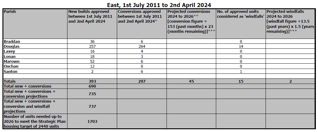
50. The most recently published RLAS study (update 17, May 2024) indicates that planning approval has been granted for 690 new dwellings in the East during the current IoMSP Plan period, and that a further 1703 residential units will need to be approved up to 2026 if the IoMSP housing target of 2440 is to be met (see Table below).
51. Further to this it should be noted that, in terms of actual housing supply as opposed to approval numbers, not all of the approvals for new housing will be taken up and that projected conversions and windfalls should not be relied upon to provide the number and type of dwellings required to meet housing need. Between RLAS Update 16 (July 2023) and RLAS Update 17 (May 2024) there has been an increase in the number of units needed in the East up to 2026 in order to meet the IoMSP housing target, and this is largely due to approvals lapsing without being implemented.
52. When published in 2019 the APE sought for an additional 964 new dwellings to be provided on allocated sites in the plan period (2011 to 2026). Table 19 of the APE provides a summary of Residential Land Provision, and the Table below is an updated version which provides comment upon the status of each site;
53. It is clear from the two Tables (above and below) that, when measured against either the 2019 Residential Land Provision Summary of the APE or the 2024 update of the RLAS, the East is experiencing a significant undersupply of housing which will continue to 2026 and beyond.
The image displays a statistical table titled 'East, 1st July 2011 to 2nd April 2024' listing planning approval data for various parishes. It details new builds, conversions, and projected windfalls across different locations.
Planning Application in early stages of preparation
DH016g
Anna Cur House
Anna Cur House
10
Current Planning Application for 12 dwellings
12
DH019g
South Quay
South Quay
86
Not currently being progressed
DH021g
South Quay
South Quay
7
Not currently being progressed
DH022g
Circular Road
Circular Road
63
Not currently being progressed
DH025g
Fairfield
Fairfield
9
Government school site, not currently being progressed
DH037g
Lower Dukes Lane
Lower Dukes Lane
6
Not currently being progressed
DH039g
Park Road
Park Road
27
Government school site, not currently being progressed
DH042g
Albany Road
Albany Road
8
Not currently being progressed
DH046g
Victoria Road Prison
Victoria Road Prison
44
Government site, not currently being progressed
DM002g
Lake Road
Lake Road
41
Current Planning Application for 109 apartments
55
DM003g
DM003g
Loch Promenade
Loch Promenade
17
Current Planning Application for Hotel & Commercial Space
DM004g
DM004g
Lord Street
Lord Street
21
Current Planning Application includes 85 apartments
40
DM007g
DM007g
Formerly Masterplan TF1 & TF2
Formerly Masterplan TF1 & TF2
10
Not currently being progressed
DM008g
DM008g
Formerly Masterplan TF3 & TF6
Formerly Masterplan TF3 & TF6
33
Current Planning Application includes 25 apartments
10
DM012g
DM012g
Summerland
Summerland
7
Government site, not currently being progressed
DM013g
DM013g
Little Switzerland
Little Switzerland
22
Planning approval for office campus, no open market residential property
DM014g
DM014g
Milestone
Milestone
6
Not currently being progressed
OH016g
OH016g
Follies Cabaret
Follies Cabaret
15
Not currently being progressed
BH034g
BH034g
Mannin Infirmary Site
Mannin Infirmary Site
23
Government site, not currently being progressed
Total of Allocated Sites
964
684 (-280) (if current PAs approved)
292 (-672)
E Recommended Strategic Reserve Sites
E Recommended Strategic Reserve Sites
E Recommended Strategic Reserve Sites
E Recommended Strategic Reserve Sites
E Recommended Strategic Reserve Sites
E Recommended Strategic Reserve Sites
E Recommended Strategic Reserve Sites
BH015s/BH019s
BH015s/BH019s
BH015s/BH019s
Woodstock & Fairway/Hilltop Nursery
15
Not released
BH031s (part)
BH031s (part)
BH031s (part)
Camlork (Field No 521518)
50
Not released
DH002s/DH057s/DM001s (DH003 & DH010)
DH002s/DH057s/DM001s (DH003 & DH010)
DH002s/DH057s/DM001s (DH003 & DH010)
Johnny Watterson’s Lane
600
Not released
OH011s
OH011s
OH011s
Ballachrink, Onchan
140
Not released
GH013s
GH013s
GH013s
Baldrine Road, Baldrine
10
Not released
DH008s
DH008s
DH008s
Ellenbrook
60
Not released
Total of Strategic Reserve Sites
Total of Strategic Reserve Sites
Total of Strategic Reserve Sites
Total of Strategic Reserve Sites
875
0
0
Grand Total
Grand Total
Grand Total
Grand Total
2440
1419 (-1021)
1027 (-1413)
54. It is also clear that there is need to provide for a continuity of housingprovision, rather than waiting for supply to dwindle altogether before bringingforward development on SR sites. The “lead in” time for a residentialdevelopment involves scheme design, consultation, obtaining planning
approval and finally construction and for the scale of development proposed can typically take more than 3 years for the first dwellings to be available. It can be seen from the Table above that even if all current major planning applications for residential development on allocated sites are approved which is far from certain - without the release of Strategic Reserve sites there will still be a significant shortfall of around 1021 approvals in relation to the 2026 IoMSP target figure. In terms of actual housing delivery, the shortfall is even more acute - given that consented schemes will not deliver the full amount of approved housing within the Plan period then the deficit in actual provision is estimated to be in the order of 1413 dwellings.
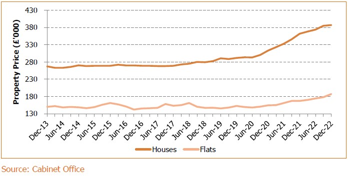
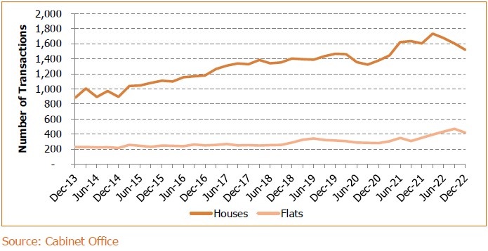
55. The RLAS figures above are reflected in the data for average property price and number of transactions as shown in the graphs below (Isle of Man in Numbers, May 2023);
A line chart displaying property price trends in thousands of pounds from December 2013 to December 2022, comparing prices for houses and flats.
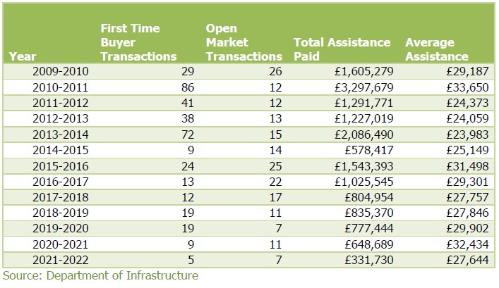
56. Development of the site as proposed will provide both property for sale on the open market and new affordable housing. The supply of First Time Buyer homes has reduced markedly over the IoMSP Plan Period, as can be seen in the Table below. Over 57% of those currently on the First Time Buyer Register want Douglas and the East as their area of choice for purchase (Isle of Man in Numbers, May 2023).
A line chart displaying the number of transactions for houses and flats from December 2013 to December 2022, sourced from the Cabinet Office.A statistical table displaying housing transaction data and financial assistance figures from 2009-2010 to 2021-2022.
57. SRRM P1 (D); this states that the deliverability of sites may be taken into account, which includes the landowner/developer’s ability to comply with the principles of the development briefs set out in the APE (see below), the willingness of the landowner/developer to pursue a planning application and develop-out the site, as well as any other material considerations relevant at that time. The landowner/developer in this instance is able to comply with the relevant Development Brief, and the submission of this application is evidence of the strong intention to obtain planning approval and develop an approved scheme to completion without delay.
58. SRRM P1 (E); it is stated that SR Sites will normally be released in order of their position in the settlement hierarchy, taking into account the circumstances evident at the time (including the need for any supporting infrastructure). The suggested order of settlement hierarchy has the edge of Main Centre sites first (Douglas), the edge of Service Centre site second (Onchan), and the edge of Village sites third (Union Mills and Baldrine). This mistakenly categorises Union Mills as a Village when in fact the IoMSP classes it as a Service Village in the settlement hierarchy.
59. In respect of Service Villages IoMSP Spatial Policy 3 states that “Housing should be provided to meet local needs and in appropriate cases to broaden the choice of location of housing”. It is therefore a policy requirement to allow for the provision of new housing in Service Villages, and the application site in this instance is the only identified housing site in Union Mills.
60. In contrast, the development requirements of the Main Centre and the Service Centre are different from those for Service Villages, both in terms of quantum of housing and the other forms of development which may be required. Further, the timing of those development needs will differ between settlements and so placing site release into a hierarchy carries the likelihood that local need in Service Villages or Villages will not be met simply because larger, more complex sites with different infrastructure needs are not yet required for development (or because owners have not brought them forward).
Importantly, the APE does not seek to control housing delivery from General Allocation sites by placing them into a release hierarchy.
61. In this instance the application site is, compared to those in the Main Centre and Service Centre, relatively small and does not require the preparation of a Masterplan to guide the development of a wider area which is within multiple ownerships. The joint owners of the application site are working together to bring it forward for development at the earliest opportunity. It represents the only opportunity to provide new housing in Union Mills within the Area Plan period, and that objective should not be frustrated by the status of other sites to which it is not comparable.
62. SRRM P1 (E); indicates that the status of all SR Sites will be reconsidered when the Area Plan is next reviewed and that the broad merits of the release mechanism will be reviewed as part of any Strategic Plan review.
63. SRRM P2; it is stated that the development of Strategic Reserve ‘Predominantly Residential’ Sites, which may also include elements for community facilities such as schools, will only be brought forward where it can be demonstrated:
i. that there is need for these sites which cannot be met by the existing allocations set out under APE Residential Proposal 1. The issue of supply from other sites is considered above.
ii. that sufficient infrastructure exists, or can be provided prior to the development being brought into use, to allow the development to function and to avoid any unacceptable impact on wider networks; this application seeks approval to the principle of developing the site as this time, and any future application which seeks approval for Reserved Matters will include details of the infrastructure requirements of the proposed development and its impact upon existing networks. Notwithstanding this the application includes information to demonstrate that satisfactory access is achievable, and MUA Drainage Division has been consulted in respect of foul and storm water drainage.
iii. that the proposals will not have any unacceptable environmental impacts (including any significant landscape impacts); similarly, this application seeks approval to the principle of developing the site as this time, and any future application which seeks approval for Reserved Matters will include an Environmental Impact Assessment. Whilst the principle of locating residential development on the application site has been established with its allocation in the APE, an EIA will not be able to consider the full impact of a scheme until a Reserved Matters application provides detail in respect of layout, density, dwelling types, access, drainage and other aspects of development.
iv. all options for different uses on the sites have been fully explored taking into account health, social care and education needs; the application site in this instance is relatively limited in size, certainly when compared to other Strategic Reserve sites such as those to the northwest of Johnny Watterson’s Lane. It is also a short distance from existing or proposed health, community and education facilities and there is no indication in the relevant APE Development Brief (see below) that any such provision will be required on site in this instance.
In respect of community facilities, Bradan Commissioners has recently developed “the Roundhouse”, a new multi-million pound community hub which includes facilities such as a sports hall, gym, function room, children’s nursery, a pharmacy, a dental studio, a beauty studio, a café, soft play area, a sensory hub, and Commissioners’ offices. The Roundhouse is close to the application site, and residential development as proposed will offer mutual benefit for both new residents and for the community hub.
64. The APE Development Brief (DB) for the site; the APE DB (para 12.22.1) sets out six criteria to guide the development of the site;
1. The site shall be used for predominantly residential development (of about 50 dwellings) and any requisite infrastructure, including recreational open space and children’s play space. This application seeks planning approval
in principle to develop the site for predominantly residential purposes, which will include associated infrastructure.
2. The Strategic Reserve Site shall be taken to include part of the field beyond the lane to the southwest of the main site. This part of the site (see below) is allocated so as to allow vehicular access from the main road.
3. The character of the surrounding residential development should be considered in the design of development of this site. This will be considered as part of the scheme to be submitted for Reserved Matters approval.
4. A Travel Plan must be submitted as part of any planning application which sets out a strategy for the delivery of sustainable transport objectives, and demonstrates how these are to be achieved and updated over time; This will be considered as part of the scheme to be submitted for Reserved Matters approval.
5. There should be no net loss of biodiversity in the development of this site; the EIA to be submitted with a Reserved Matters application will include an
A planning map showing the Marown area with a specific site labeled BH031s highlighted in pink hatching and settlement boundaries outlined in purple.
Ecological Impact Assessment, which amongst other things will consider the consequences of development upon biodiversity.
6. An Environmental Impact Assessment will be needed for any development proposed on this site; should planning approval in principle be granted for the residential development of the site an EIA will be undertaken in respect of the proposed scheme and will accompany a Reserved Matters application.
65. Access arrangements; as stated above, the part of the site which is on the western side of Trollaby Lane is specifically allocated for development so as to allow the formation of a new highway junction and access road into the site. It is implicit in the APE allocation therefore that the principle of creating a vehicular access at this point is acceptable.
66. Whilst the application proposes to reserve all matters of detail, including those relating to highways, information has nonetheless been included which demonstrates that the site can be accessed in a safe and acceptable manner. These details are not definitive and may change when included in a Reserved Matters application, but they show that suitable access to any housing on the site can be established. They also show that highway & junction arrangements at the south western end of the site can be designed to serve residential development on the application site without prejudicing potential future use as part of a link road which runs towards Strang. A Technical Note in respect of access has been provided by I-Transport and is appended to this Planning Statement.
67. As part of the initial highway design process an assessment of existing trees has been undertaken and the report is included with this application. Any tree loss would be mitigated by new planting adjacent to existing hedgerows and the proposed access road which would make a significant contribution to the amenities of the area, offsetting the visual amenity impact and loss of tree canopy cover that would result from the access proposals.
68. Drainage arrangements; consultation has taken place with MUA Drainage regarding the principle of linking new development in this location into the public drainage networks. The MUA outlined a number of network upgrade/improvement scenarios which could potentially be required in order to service new dwellings, but any such arrangements would have to be considered in the light of a detailed development proposal. This application seeks approval in principle for development and there should therefore be no drainage-related reason to prevent approval at this stage. Summary
69. The site which forms the subject of this planning application is located on the north western side of Union Mills village, and forms part of the wider area known as Camlork. The site is identified in the Area Plan for the East as a Residential Strategic Reserve. This application seeks Planning Approval in Principle to develop the site for residential purposes.
70. The granting of Planning Approval in Principle will allow the site to be brought forward for residential development, which will;
Help to ensure continuity of housing supply in the East of the Island, including affordable housing;
Help to facilitate the growth of the Island’s population in accordance with the Government’s Economic Strategy;
Provide an opportunity to meet local housing need and “broaden the choice of location of housing” in Union Mills;
Establish the southern end of a potential highway link between Peel Road and Mount Rule Road which, subject to future land use zonings, would improve access to Nobles Hospital and reduce the need for vehicles to use Strang Road.
71. Upon the granting of planning approval (in principal and, subsequently, reserved matters) the site would be available for development immediately. It
would represent a sustainable extension to an existing residential area and would be adjacent to the existing settlement boundary of Union Mills.
72. The APE includes details of a SR release mechanism. The site has not been considered by CABO for formal release, and as such this planning application represents an alternative mechanism for establishing that the site can be brought forward for development in order to help address housing need. The granting of planning approval in principle will, in essence, have the same practical result as the SR being released by CABO - in both instances there will remain a requirement to submit a future planning application which will seek approval for the details of a development proposal, but the ability of the site (including, crucially, the willingness of the owner) to deliver new housing to help meet relevant targets will have been established.
73. APE Strategic Reserve Release Mechanism Proposals 1 & 2 (SRRM P1 & P2) are intended to guide CABO when considering the release of Strategic Reserve sites, and as stated above this planning application represents an alternative mechanism for establishing that the site can be brought forward for development. Whilst the provisions of SRRM P1 & P2 do not therefore provide criteria against which to formally assess planning application proposals, they can provide a starting point for such an assessment.
74. Residential Land Availability Study Update 17 indicates that a further 1703 dwellings will need to be approved before 2026 if IoMSP housing targets are to be met. The allocated sites identified in the APE will in total only provide an estimated 964 dwellings, and many of those sites will not be brought forward in the Plan period. When the provision Table is updated to take account of RLAS 17 and current planning applications the situation remains stark - even if all current major planning applications for residential development on allocated sites are approved - which is far from certain - without the release of Strategic Reserve sites there will still be a significant shortfall of around 1021 approvals in relation to the 2026 IoMSP target figure. In terms of actual housing delivery, the shortfall is even more acute - given that consented schemes will not deliver the full amount of approved housing within the Plan
period then the deficit in actual provision is estimated to be in the order of 1413 dwellings. It is clear, therefore, that the “release” of Strategic Reserve land at this time is essential if housing and economic targets - in the East and the Island overall - are to be met.
75. Whilst the APE suggests that the release of SR land should be by way of hierarchy, the development requirements of the Main Centre and the Service Centre are different from those for Service Villages, both in terms of quantum of housing and the other forms of development which may be required. Further, the timing of those development needs will differ between settlements and so placing site release into a hierarchy carries the likelihood that local need in Service Villages or Villages will not be met simply because larger, more complex sites with different infrastructure needs are not yet required for development (or because owners have not brought them forward).
76. In this instance the application site is, compared to those in the Main Centre and Service Centre, relatively small and does not require the preparation of a Masterplan to guide the development of a wider area which is within multiple ownerships. The joint owners of the application site are working together to bring it forward for development at the earliest opportunity. It represents the only opportunity to provide new housing in Union Mills within the Area Plan period, and that objective should not be frustrated by the status of other sites to which it is not comparable.
77. This application seeks planning approval in principle, with all matters of detail to be Reserved. Notwithstanding this, information has been included which demonstrates that a suitable access can be provided from the adjacent highway, and consultation with MUA Drainage has confirmed that there should be no drainage-related reason to prevent approval in principle being granted at this stage.
78. It is concluded therefore that there is no material reason why Planning Approval in Principle for the provision of new homes on the application site as now proposed should be withheld.
Copyright in submitted documents remains with their authors. Request removal