Loading document...
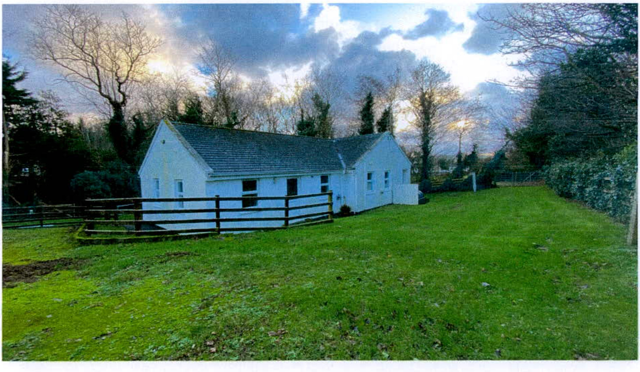
24 0532
Sarah Corlett Town Planning Consultancy Ltd Registered address: Ballachrink Croft, Ballacorey Road, Bride, Isle of Man IM7 4AW t: 07624 485517 e: [email protected] w: www.sarahcorlett.com Directors: Sarah Elizabeth Corlett, Nicola Jane Corlett Company Registration 134325C
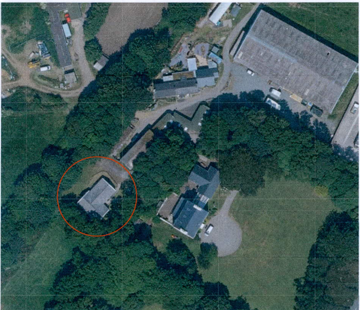
1.1 The two conjoined cottages were originally approved when they were part of the holding of Glebe Farm/Pennybridge Stables and are now owned in association with The Old Vicarage. Access to the cottages remains through Glebe Farm, down the farm lane where it meets the A3 highway to the south of the fuel filling station.
1.2 The cottages are single storey, traditionally styled units which sit in a lawned setting surrounded by established trees and hedging. The former railway line public footpath runs immediately to the west.
Sarah Corlett Town Planning Consultancy Ltd Registered address: Ballachrink Croft, Ballacorey Road, Bride, Isle of Man IM7 4AW t: 07624 485517 e: [email protected] w: www.sarahcorlett.com Directors: Sarah Elizabeth Corlett, Nicola Jane Corlett Company Registration 134325C
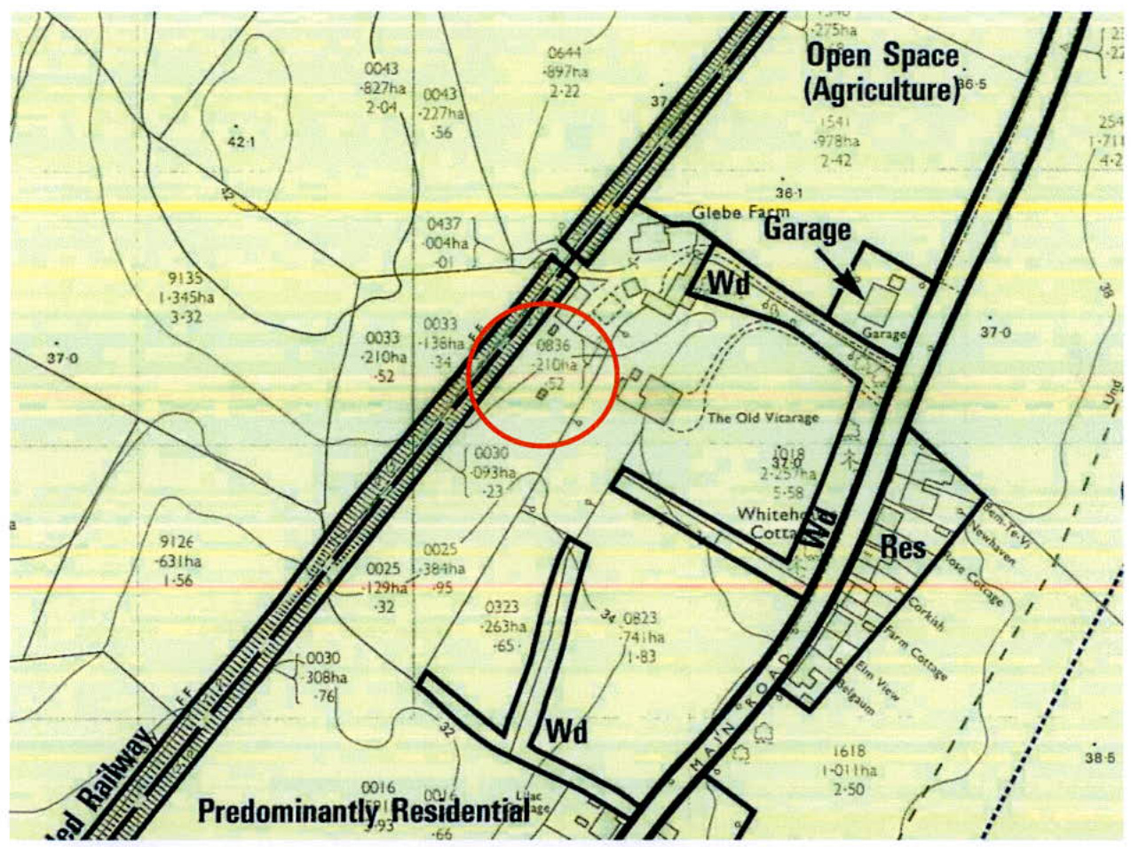
2.1 The site lies within an area designated on the adopted Kirk Michael Local Plan (1994) as Predominantly Residential.
2.2 The older development plans - the Local Plans, the Isle of Man Planning Scheme (Development Plan) Order 1982 and in some cases, Area Plans, are in the process of being updated in the form of larger scale (wider area) plans of which there are currently two - the Area Plan for the South (2013) and the East (2020). The Cabinet Office is currently in the process of preparing an Area Plan which will cover the north and west of the Island, ultimately replacing all of the adopted development plans in this area. That plan is currently in draft form and is anticipated to be the subject of a public inquiry in July this year.
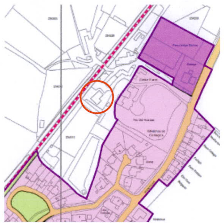
2.3 This plan currently shows the site (circled in red below) as outside of the settlement boundary (the purple line) and is designated as not for a particular purpose:
2.4 Kirk Michael is identified in the Strategic Plan as a Service Village. This level of settlement sits below the Service Centres and Douglas, and above the "remaining villages". Within Service Villages, "Area Plans will define the development boundaries of such villages so as to maintain and where appropriate increase employment opportunities. Housing should be provided to meet local needs and in appropriate cases to broaden the choice of location of housing" (Spatial Policy 3).
2.5 Where development is consistent with the relevant development plan, General Policy 2 sets out standards of development which should be achieved:
General Policy 2: Development which is in accordance with the land-use zoning and proposals in the appropriate Area Plan and with other policies of this Strategic Plan will normally be permitted, provided that the development: (a) is in accordance with the design brief in the Area Plan where there is such a brief;
TOWN PLANNING CONSULTANCY (b) respects the site and surroundings in terms of the siting, layout, scale, form, design and landscaping of buildings and the spaces around them; (c) does not affect adversely the character of the surrounding landscape or townscape; (d) does not adversely affect the protected wildlife or locally important habitats on the site or adjacent land, including water courses; (e) does not affect adversely public views of the sea; (f) incorporates where possible existing topography and landscape features, particularly trees and sod banks; (g) does not affect adversely the amenity of local residents or the character of the locality; (h) provides satisfactory amenity standards in itself, including where appropriate safe and convenient access for all highway users, together with adequate parking, servicing and manoeuvring space; (i) does not have an unacceptable effect on road safety or traffic flows on the local highways; (j) can be provided with all necessary services; (k) does not prejudice the use or development of adjoining land in accordance with the appropriate Area Plan; (I) is not on contaminated land or subject to unreasonable risk of erosion or flooding; (m) takes account of community and personal safety and security in the design of buildings and the spaces around them; and (n) is designed having due regard to best practice in reducing energy consumption. 2.6 On the draft Area Plan for the North and West there are no environmental constraints identified on the relevant map: the area of Registered Trees surrounding the Vicarage are shown (in dark orange below) with a small area of ecological value shown to the south to the rear of 9 - 15 (odd nos), Faaie ny Cabbyl. This is shown more clearly on the Island Environment Map which also shows the Conservation Area (CA) (pale yellow colouring which continues underneath the area of Registered Trees) which extends as far as and includes the site with the former railway line forming the boundary of the CA at this point. The CA also includes all of the buildings at Glebe Farm other than the large equestrian building to the north of the access lane, and it does not include the fuel filling station or any of Faaie ny Cabbyl.
2.7 There are no Infrastructural Constraints identified on this site on the appropriate map accompanying the draft Area Plan for the North and West.
2.8 The site is not shown as being at risk of any flooding on the national flood risk maps and the site is well outside the area subject to coastal erosion.
2.9 Despite being excluded from the settlement boundary in the draft Area Plan for the North and West, on the Landscape Character Assessment which is encapsulated into a draft
Sarah Corlett Town Planning Consultancy Ltd Registered address: Ballachrink Croft, Ballacorey Road, Bride, Isle of Man IM7 4AW t: 07624 485517 e: [email protected] w: www.sarahcorlett.com Directors: Sarah Elizabeth Corlett, Nicola Jane Corlett Company Registration 134325C
Planning Policy Statement (2/09) with the original map in the 2008 document included in this, the site is shown as being within the settlement of Kirk Michael with the railway line forming the boundary of the village with the surrounding countryside at this point.
2.10 Development within Conservation Areas must preserve or enhance the character or appearance of the Area and take into account its special interest (Environment Policy 35 of the Strategic Plan and Planning Policy Statement 1/01 - Conservation of the Historic Environment of the Isle of Man).
2.11 The Kirk Michael Conservation Area has a Character Appraisal which was prepared for the adoption of the Conservation Area in 2006. This discusses the evolution of the village, starting in 1869 when it stretched from the Courthouse to the Old Vicarage. There are numerous mentions of the Old Vicarage within the document, even suggesting its special interest but not going as far as recommending that it be considered for Registration. No reference is made to the cottages which are the subject of this application.
3.1 Planning approval was granted for the cottages under 04/02175/B. The application proposed the buildings as tourist accommodation and the application was permitted subject, inter alia, to conditions which restricted the occupancy as follows: between the 1st March and 1st October in any one year the holiday accommodation hereby approved must only be used for individual lets, not exceeding four weeks in duration, to bona fide tourists. Outside of this period longer lets to bona fide tourists are permissible. 3.2 Access to the proposed cottages was through Glebe Farm, down the lane and out onto the A3. 3.3 The cottages have not been subject to any further applications although the surrounding land has as follows:
23/01330/B - expansion of camping area and installation of 14 electric hook up points for camper van pitches - pending consideration 20/00175/B - Change of use of land to create a camp site, creation of hard standing for camping vehicles with associated electric hook up points, installation of cladding to and relocation of existing toilet / wash facilities and erection of an attached motorcycle shelter, relocation of a wooden structure to provide a café and social area and construction of decking - refused at appeal 18/00993/C - creation of campsite for TT and MGP - permitted 14/01001/B - creation of temporary campsite with shower and toilet facilities - permitted
16/01375/B - Approval in principle for redevelopment of farm yard - stables, farmhouse and equestrian building alongside farm lane for solely residential development, including improved access to holiday cottages. Proposed creation of access from former railway line footpath to field 244230 - permitted 16/01009/B - approval in principle for the erection of four detached dwellings - withdrawn (this was to replace the exiting barns on site) 07/01129/B - demolition of existing stables and barn and erection of nine new stables and creation of an access to tourist accommodation - permitted 07/00823/B - extension to farmhouse - permitted
06/01548/B - extension to Glebe Farmhouse - permitted 06/01208/B - extension to existing stables and erection of detached store - permitted 00/00527/B - conversion of agricultural building to farm dwelling - refused 98/01547/B - erection of dwelling and garage - permitted (this appears to be on the site of the current cottages) 97/01552/B - approval in principle for erection of dwelling and two stables - permitted (this appears to be on the site of the current cottages) 94/01068/A - approval in principle for erection of dwelling - permitted (this appears to be on the site of the current cottages) 93/01563/B - erection of 8 loose boxes - permitted
96/00730/B - erection of an agricultural building - permitted 97/01749/B - extension to agricultural/equestrian building for function room and associated rooms and facilities - refused 15/00539/A - approval in principle for replacement of riding arena with four dwellings permitted 19/00873/B - conversion of existing equestrian riding school to provide 9 light industrial units - refused at appeal 21/00644/B - erection of replacement building to provide 5 industrial units - permitted
4.1 Proposed is the additional use of the two cottages as two residential properties. No physical changes are proposed to the buildings and neither is any change proposed to the site or means of access which will remain through Glebe Farm/Pennybridge Stables. 4.2 We would submit that the cottages have all of the required amenities for occupation as private dwellings: each has a private garden area that is not overlooked and sufficient car parking for two vehicles per unit. Whilst access is between existing agricultural/equestrian buildings in the ownership of others, it is easily possible for vehicles to drive along the lane and access the site, turn and return out in a forward direction and it is understood that fuel is delivered to the site in a large vehicle on a regular basis without issue. 4.3 The site is within safe and convenient walking distance of Kirk Michael's school, church, shops and amenities as well as being on a regular bus route and next to the long distance footpath. 4.4 Whilst the original approval was granted for tourist accommodation, this was what was proposed, planning approval having been granted previously for permanent residential accommodation in this part of the site. 4.5 The remainder of Glebe Farm has been the subject of many applications for change and for new buildings and uses, some resulting in additional traffic which does not appear to have been an issue. 4.6 The use of the premises for permanent residential accommodation will not generate significantly greater levels of traffic and as the space standards for permanent living accommodation are greater than for tourist accommodation, the amount of people on site is likely to reduce as a result of the proposed additional use. 4.7 The site is currently designated for predominantly residential use and whilst the draft Area Plan for the North and West excludes the cottages from the settlement, the Landscape Character Assessment clearly considers the site not to be within the countryside. As such, it is submitted that the proposal is consistent with the character and nature of the area and with the currently adopted land use designation of the site.
TOWN PLANNING CONSULTANCY 4.8 Whilst the site is within a Conservation Area, there are no changes proposed to the building and its additional use is not considered to have any impact on the character or appearance of the CA. Given that the cottages are not referred to at all in the CA Assessment, it is not considered that the additional use will have any impact on it. The character and appearance of the CA will therefore be preserved, satisfying EP35 and the Planning Policy Statement 1/01 - Conservation of the Historic Environment of the Isle of Man.
4.9 We would submit that the proposal will allow flexibility in the occupation of these cottages to ensure their continued usage which in turn will support their continued maintenance and upkeep. They are modest properties whose additional use as residential accommodation will not generate any significant change in impact and we would submit that the proposal complies with all of the current, adopted policies applicable to this site.
08.04.24
Copyright in submitted documents remains with their authors. Request removal
View as Markdown