Development of Land Adjacent to Castle View Nursing Home, Glenfaba Rise and Peel Golf Course with a Scheme of 92 Dwellings, Highways and Drainage Infrastructure, and Public Open Space; and
Re-development of Redundant Farm Building Group at Ballaterson Farm with Replacement Dwelling and Conversion of Outbuildings to Form Tourist Accommodation
January 2024
Dandara Homes Limited, Isle of Man Buisness Park, Cooil Road, Braddan, Isle of Man IM2 2SA
Dandara Homes Limited Development of Land Adjacent to Castle View Nursing Home, Glenfaba Rise and Peel Golf Course (Fields 311843, 311884, 314537, 314549, 315926, 315927, 315939, 315940 & 316039) with a Scheme of 92 Dwellings, Highways and Drainage Infrastructure, and Public Open Space; and Re-development of Redundant Farm Building Group at Ballaterson Farm with Replacement Dwelling and Conversion of Outbuildings to Form Tourist Accommodation Planning Statement
Contents
Executive Summary
The Site
Policy Background
Planning History
The Proposed Development
Summary and Conclusions
Appendices
1. A summary of the applicant’s responses to points raised in the Major Application Trial
2. Energy Impact Assessment/Statement
3. Economic Impact Statement
Executive Summary
1. The application site is adjacent to existing development on the south western side of Peel and consists of five fields of agricultural grazing land and part of an adjoining stream valley, along with the farmhouse and redundant outbuildings of Ballaterson Farm. The application seeks detailed planning approval to develop the site with 92 dwellings and associated Public Open Space, highways and drainage infrastructure, with all of the new dwellings to be located within an area which is allocated for residential development in the extant Peel Local Plan. An affordable housing contribution in the form of 23 on-site dwellings will be made as part of the development. In addition, the farmhouse and outbuildings of Ballaterson Farm are no longer required for agricultural purposes and it is proposed to redevelop the group with a replacement dwelling and to convert retained outbuildings into tourist accommodation.
2. Vehicular access to the proposed development is to be taken from Glenfaba Road via Glenfaba Rise (Raad Rogan), with a new section of highway to be provided alongside the boundary of Castle View Nursing Home which will allow access to new dwellings (for new residents and construction traffic) without the need to travel through the existing Glenfaba Rise development. Foul drainage will feed to the public mains system – albeit with provision in the scheme for a temporary on-site treatment plant to cover any unforeseen delay in the availability of the new MUA public treatment works – and surface water will be attenuated on site before being taken to an existing watercourse.
3. Two principal areas of Public Open Space will be provided on site; a relatively open and flat area to the south of Castle View Nursing Home and the stream valley at the southern site boundary. Footpaths will be carefully created within the northern side of the valley so that the public
can enjoy spending leisure time there without harming its character or ecological value.
4. The application is accompanied by supporting information which includes;
a Transport Assessment, which concludes that vehicular and non-vehicular access to the application proposals accord with the policies of the Isle of Man Strategic Plan and hence that the trips which they are likely to generate can be accommodated on the local highway network without detriment to the safety or convenience of its users;
a Design & Access Statement, which outlines the architectural approach taken for the scheme and how it will result in a high quality development for residents and other users of the area;
an Ecological Impact Assessment produced by Ecology Vannin, along with a Bat Survey and Tree Survey, which have helped to guide the design process for the proposed development;
a Site & Construction Environmental Management Plan, which includes Precautionary Working Method Statements;
a structural/condition report in respect of the existing farm buildings; and
this Planning Statement, which includes an Economic Impact Statement and which concludes that there is no material reason why Planning Approval for the scheme as proposed should be withheld.
5. The development as proposed will bring social and economic benefits to both the local area and the Island as a whole. It will provide new housing for which there is a current need, including affordable housing,
and will use redundant outbuildings to provide tourist accommodation. When assessed in the context of the Department’s Supplementary Planning Guidance on Economic Issues the development as proposed will contribute positively to the delivery of the approved Isle of Man Economic Strategy.
6. The development proposals have formed the subject of a Major Application Trial submission, and the scheme has been amended in response to feedback from consultees1. Consultation has also taken place with other relevant parties, including Peel Town Commissioners. This Planning Statement helps to demonstrate that the proposal is in accordance with relevant planning policy and guidance, and that there is hence no material reason why Planning Approval for the scheme as proposed should be withheld.
The Site
7. The application site has an area of approximately 8.3 hectares and consists primarily of fields 311843, 311884, 314537, 314549, 315926, 315927, 315939, 315940 & 316039 which are located immediately to the south & south east of Castle View Nursing Home and the Glenfaba Rise residential development on the south western side of Peel. The five northern-most fields are currently used for agricultural grazing and are generally divided by sod banks/hedges with occasional trees, whilst the fields to the south contain a relatively steep-sided stream valley which is more heavily vegetated towards its western boundary.
8. The site also includes the former farmhouse and outbuildings of Ballaterson Farm, which have been unused since the previous farmer retired and are no longer required for agricultural purposes. The farmhouse is a two storey structure which has been renovated over time, with a smaller stone outbuilding attached at one gable end. The adjacent farmyard is enclosed by outbuildings of varying size and style,
1 A summary of the applicant’s responses to points raised in the MAT is attached at Appendix 1
some of which are formed from traditional materials (stone walls, slate roofs).
9. The northern boundaries of fields 311843 & 315926 are shared with the rear gardens of existing dwellings within Glenfaba Rise. Those dwellings are all two storey and include detached, semi-detached and terraced properties. Peel Golf Course adjoins the site to the north, east and south, with a further agricultural field (311881) immediately outside the site to the south of the Ballaterson Farm building group.
Policy Background
10. The Isle of Man Strategic Plan; the Isle of Man Strategic Plan (IoMSP) was first adopted by the Department in June 2007 and approved by Tynwald the following month, and is intended to provide “the strategic and general policy framework within which provision will be made for development and conservation needs for the period 2001-2016”. Together with Area Plans the IoMSP forms a Development Plan as required by the 1999 Town and Country Planning Act. It is explained in the IoMSP that existing Local Plans will remain in effect until they are replaced by new Area Plans, and that the 1982 Development Plan, as amended by the various Local Plans, will have effect as an Area Plan. It is also made clear in the Plan that “in the case of any inconsistency between the provisions of the Strategic Plan and the provisions of an Area Plan, whichever came into force later will prevail”. The Isle of Man Strategic Plan 2016, which contains updated population statistics and housing policies for the period 2011 to 2026, was approved by Tynwald in March 2016.
11. Amongst other things the Strategic Objectives of the Plan (pages 11-
12) seek to promote efficiency and economy in the protection, use, and re-use of resources, and they indicate that most new development should be guided towards existing settlements in order to make “the
optimum use of existing and planned infrastructure and services”. They also seek to protect, maintain and enhance the built and rural environment, to encourage high quality development throughout the Island, and to ensure that new development relates well to public transport facilities. The Plan also includes Strategic Objectives which state that the housing needs of the community should be met by the provision of sufficient housing of an acceptable standard and of an appropriate nature and in appropriate locations, and that high standards of residential amenity in new development and a physically safe environment will be promoted.
12. The Strategic Policies which flow from these objectives (pages 14-19) emphasize the need to make the best use of resources by “optimising the use of previously developed land, redundant buildings, unused and under-used land and buildings, and re-using scarce indigenous building materials”, by “ensuring efficient use of sites, taking into account the needs for access, landscaping, open space, and amenity standards” and “being located so as to utilise existing and planned infrastructure, facilities and services”. New development will be located primarily within existing settlements or within sustainable urban extensions (with identified exceptions for development in the countryside), and should be designed so as not to detract from the character of towns and villages. New development, including individual buildings, should be designed so as to make a positive contribution to the environment of the Island and in appropriate cases the Department will require planning applications to be supported by a design statement. Tourist development proposals will generally be permitted where they make use of existing built fabric of interest and quality, and it is stated that new development should be located and designed so as to promote a more integrated transport network.
13. The IoMSP includes an Island Spatial Strategy (ISS, pages 20-29) which is intended to guide the physical development of the Island up to
2016 (although given that the Plan’s housing figures have been revised it can be assumed that whole Plan is to be considered relevant to the period 2011-2026). The Island is divided into North, South, East and West regions and the ISS seeks to “promote a balanced and equitable pattern of sustainable development across the Island”. Peel is identified at Spatial Policy 2 (page 26) as a Service Centre which will “provide regeneration and choice of location for housing, employment and services”. SP2 goes on to state that “Area Plans will define the development boundaries of such centres so as to provide a range of housing and employment opportunities at a scale appropriate to the settlement”.
14. It is estimated in the ISS that in order to meet the housing needs of the Island over the revised plan period (2011-2026) provision will have to be made for the development of 5,100 additional dwellings, and the Plan indicates that the Island’s western region – which is comprised of Peel, Patrick, German and Michael – will accommodate 770 of those dwellings. The most recent Residential Land Availability report (Update 15, published July 2022) indicates that the number of units required to meet housing need in the west for the revised plan period (2011-2026) currently stands at 241.
15. Chapter 6 of the Plan is entitled General Development Considerations, and it is made clear in the introduction that the Development Plan “will make positive land-use allocations and provision through its policies such as to meet the Island’s foreseen development needs for the period 2001-2016”. Again, given that the Plan’s housing figures have been revised it can be assumed that the whole Plan is to be considered relevant to the period 2011-2026. The Plan will therefore provide the basis upon which development control decisions are made during this period, with General Policy 1 (page 32) confirming that the determination of such shall have regard to the provisions of the Development Plan and all other material considerations. General Policy
2 of the Plan (pages 32-33) identifies broad standards of development to be taken into account if proposals are to be permitted, which include criteria in respect of building siting, layout, form and appearance, impact upon landscape or townscape, amenity standards for residents, highway safety and traffic flows, and parking space provision. Transport Policy 7 (page 101) requires parking provision in all new development to meet the Department’s standards, which is shown at Appendix 7 of the IoMSP (page 139) to be 2 spaces per unit for typical residential and terrace development. General Policy 3 (page 33) indicates that development will not be permitted outside of areas which are zoned for development unless it accords with one of the listed exceptions.
16. Environment Policy 1 (page 38) states that the countryside, which does not include land which is designated for future development on an Area Plan, will be protected for its own sake. Subsequent policies in respect of the Rural Environment seek to ensure that development will not have an adverse effect upon landscape character, woodland, areas of ecological interest, watercourses, the coastal environment, areas affected by erosion or flooding, or important agricultural land. Environment Policy 16 (page 48) states that the use of existing rural buildings for new purposes such as tourist use may be permitted where, amongst other things, it is demonstrated that the building is no longer required for its original purpose and where the building is substantially intact and structurally capable of renovation, and where the reuse of the building will result in the preservation of fabric which is of interest or attraction. Environment Policy 42 (page 58) requires the design of new development in existing settlements to take account of “the particular character and identity, in terms of buildings and landscape features, of the immediate locality”.
17. Housing Policy 1 (page 67) states that provision will be made for up to 5,100 additional dwellings over the period of the Plan, which will be subject to a “Plan, Monitor and Manage” approach by the Department.
Housing Policy 2 (page 67) states that the Department will seek to ensure an adequate supply of housing land, and goes on to suggest that designated land which is not made available for development could be placed in a land-bank and alternative land allocated for development in its place. Housing Policy 3 (page 69) confirms the distribution of dwellings suggested by the ISS, and Housing Policy 4 (page 69) states that housing should primarily be located within existing settlements or within sustainable urban extensions – identified exceptions to this include the conversion of redundant rural buildings in accordance with Housing Policy 11 and the replacement of existing rural dwellings and abandoned dwellings in accordance with Housing Policies 12, 13 and 14.
18. Housing Policy 5 (page 70) indicates that the Department, when granting planning permission on land which is zoned for residential development or in predominantly residential areas, will normally require that 25% of new dwellings on sites of 8 or more units will be affordable. The supporting text outlines the factors to which the Department will have regard when assessing the appropriate percentage in each instance.
19. Housing Policy 11 outlines circumstances where existing rural buildings may be converted into dwellings, whilst Housing Policies 12, 13 and 14 set out guidance for the replacement of existing dwellings in the countryside (stating that, amongst other things, replacement will generally be permitted unless the existing building has lost its residential use by abandonment or the existing dwelling is of architectural or historic interest and is capable of renovation).
20. Business Policy 11 (page 86) requires tourism development to be in accordance with the sustainable development objectives of the Plan, whilst noting that within rural areas there may be situations where existing rural buildings could be used for tourist use and that
Environment Policy 16 sets out the circumstances where this may be permitted. It is stated at Business Policy 12 (page 87) that permission will generally be given for the conversion of redundant buildings in the countryside to tourist use providing that the development complies with the policies set out in the Housing chapter of the Plan. Business Policy 14 (page 87) states that tourism development may be permitted in rural areas provided that it complies with the policies in the Plan, and that farmhouse accommodation or quality self-catering units in barn conversions will be encouraged but must comply with General Policy 3 and Business Policies 11 and 12.
21. Recreation Policy 3 (page 91) states that, where appropriate, new development should incorporate landscaped amenity areas into the design and that new residential schemes of ten or more dwellings must make provision for recreation and amenity space in accordance with the standards specified at Appendix 6 of the Plan. The Plan makes it clear that the general standards of space provision set down for new residential development will be applied having regard to criteria such as the size, type and particular needs of the resident population, the needs of visitors to the area and the proximity and availability of existing Open Space, including the foreshore, public glens and parks.
22. Appendix 6 of the Plan (pages 132-136) provides guidance in respect of open space requirements for new residential development, and confirms that the exact open space requirement will depend upon the individual circumstances and nature of each planning application. It goes on to differentiate between “open space” and “outdoor playing space”, confirming that the latter may include sports and recreation facilities that are designed to serve the needs of either the general public or the members of a private organisation. It may also include formal or informal areas which are designed for children’s play, but excludes areas such as woodlands and golf courses. The Plan sets the overall open space standard at 32 sq.m for each new resident, which is
broken down further into 18 sq.m of formal space such as sports pitches, 6 sq.m of children’s play space and 8 sq.m of amenity space. It also sets the assumed occupancy levels for new dwellings, and explains that where possible open space should be provided in the first instance on-site or off-site where this would improve the quality of the development and the open space provided. Where these options are not practical then commuted sums will be considered.
23. Transport Policies 1 and 2 (pages 99 & 100) require new development to be located, where possible, close to existing public transport facilities and routes, including pedestrian, cycle and rail routes, and where appropriate to make provision for new routes including links into existing systems. Transport Policy 4 of the Plan (page 100) seeks to ensure that new and existing highways are capable of safely accommodating the vehicle and pedestrian journeys created by development, Transport Policy 7 refers to parking standards (see above) whilst Transport Policy 8 (page 102) requires all applications for major development to be accompanied by a Transport Assessment. The Plan recognises that development will be required in areas not yet connected to IRIS, and that interim drainage measures such as individual treatment works may be appropriate. Infrastructure Policy 1 (page 105) states that development shall only take place in areas that will ultimately be connected to IRIS, whilst Infrastructure Policy 2 (page
105) states that interim drainage arrangements for development in areas awaiting connection to IRIS shall be submitted to and approved by the Department. Energy Policy 5 (page 113) requires proposals for more than 5 dwellings to be accompanied by an Energy Impact Assessment2.
24. The Peel Local Plan; the Peel Local Plan and Written Statement (Planning Circular 6/89) was adopted by Tynwald on 19th April, 1989, and indicates that the whole of the site is within an area which is
2 An Energy Impact Assessment/Statement is attached at Appendix 2
designated for Predominantly Residential use. Policy 5.3 of the Plan states that “Land for residential development on the perimeter of the town will be allocated”. Policy 5.14 states that “New residential development will be to appropriate densities in order both to meet the requirements of the population and to reduce the impact on the countryside”. Policy 5.15 indicates that “Comprehensive landscape proposals will be required as part of future submissions”. The Plan also requires that a minimum of 1.5 car parking spaces be provided for each dwelling, which may include a garage and which, dependent upon the layout of an area, may be required to be behind the building line. This standard may be applied with flexibility for town centre and redevelopment schemes (Policy 5.13, Policy 7.7 and Policy 7.8). Policy 11.1 states that any strategy for the provision of health services in Peel should have regard to the fact that the allocation of areas for residential development may result in population increases, which may also result in a need for additional educational facilities (para 12.2).
25. The Emerging Area Plan for the North and West; a Draft Area Plan for the North and West (APNW) was published in June 2022, with a further Draft Plan for examination at Inquiry yet to be published. The application site in this instance – with the exception of the farm building group and that part of the stream valley which is on the southern side of the watercourse – is identified in the Draft Plan as Site PR002 and is allocated for Predominantly Residential use.
26. The Draft Plan includes a Development Brief for Site PR002 (with an acknowledgement that it will be refined after public consultation), which amongst other things states that no development shall take place until the Regional Sewage Treatment Works planned to serve Peel and the West is operational, and that if there is certainty about when the new works will be operational it may be possible for a planning condition to be used to restrict properties being occupied until the necessary regional infrastructure is in operation. It goes on to explain that this is to
ensure that there is no significant additional discharge of untreated sewage/wastewater into Peel Bay.
27. Similarly, it is also proposed in the Draft Plan that any further development applications on land in Peel will need to provide clear information about how the proposed development will be drained (including wastewater), with applications to be judged taking into account the level of additional discharge into the public sewerage system and any added harm on biodiversity, ecosystem health and human health. The Draft Plan encourages consideration of using SuDS in development design.
28. The Draft Plan provides guidance in respect of density of development and suggests that proposals should seek to demonstrate that local density figures and the characteristics of the local area have been taken into account. It is estimated in the Draft Plan that the development of Site PR002 may yield in the region of 90 dwellings.
29. It is also stated in the Draft Plan that development proposals for new edge-of-town residential sites, which includes Site PR002, must demonstrate that they have taken into account the needs of future (as well as existing) residents in terms of health and social care, education, neighbourhood shops as well as demand for other community facilities, open space/play space.
30. The Draft Plan includes maps which identify environmental and infrastructure constraints to development, for example land which is subject to a statutory ecology/wildlife designation or is recognised as a non-statutory Wildlife Site. The application site is not shown to be within or adjacent to a constrained area.
Planning History
31. With the exception of the farm building group the site has not been the subject of previous planning applications. The existing housing at
Ballatessan Meadow was approved under PA 00/02395/B and PA 19/01155/B, and Castle View Nursing Home was approved under PA 06/01404/B (and subsequently extended under PA 11/01621/B).
32. The farm building group has been the subject of applications which sought approval for agriculture related development, including the erection of a new barn and the re-roofing of a milking shed. Planning approval was also granted for the installation of replacement windows to the farmhouse (PA 08/00467/B).
The Proposed Development
33. The application seeks detailed planning approval to develop the site with 92 dwellings and associated Public Open Space, highways and drainage infrastructure. In addition it is also proposed to redevelop the Ballaterson Farm building group by replacing the existing dwelling with a new house and converting retained outbuildings into holiday accommodation.
34. The scheme is comprised of a mix of dwelling types and designs and will deliver an affordable housing contribution of 23 dwellings which accords with the 25% general requirement of the IoMSP. Should the DoI Housing Division advise that it does not require all of the affordable dwellings to be provided on site at this time then part of the contribution could alternatively be made in the form of commuted sums.
35. Vehicular access to the proposed development is to be taken from Glenfaba Road via Glenfaba Rise (Raad Rogan), with a new section of highway to be provided alongside the boundary of Castle View Nursing Home which will allow access to new dwellings (for new residents and construction traffic) without the need to travel through the existing Glenfaba Rise development. Foul drainage will feed to the public mains system – albeit with provision in the scheme for a temporary on-site treatment plant to cover any unforeseen delay in the availability of the
new MUA public treatment works – and surface water will be attenuated on site before being taken to an existing watercourse.
36. Two principal areas of Public Open Space will be provided on site; a relatively open and flat area to the south of Castle View Nursing Home and the stream valley at the southern site boundary. Footpaths will be carefully created within part of the valley so that the public can enjoy spending leisure time there without harming its character or ecological value.
37. This Planning Statement considers the proposal in the context of relevant planning policy and guidance, and assessment of the principal issues is outlined below;
38. The principle of residential development; the part of the application site which will accommodate 92 new dwellings is shown in the extant Peel Local Plan to be within an area which is allocated for Predominantly Residential use. The housing need figures of the IoMSP are not intended to be a “ceiling” or upper limit, but in any event the most recent RLAS update indicates a need for 241 dwellings in the West and the proposed development will not result in that figure being exceeded.
39. In addition, part of the stream valley at the southern site boundary is within the application site boundary but is outside of the area which is allocated for residential development – it is zoned as open space, i.e. within the countryside. It is proposed for the stream valley to remain as open space, with new footpaths to be carefully created on the northern side of the stream on land which is allocated for residential development (the stream marks the boundary), thus allowing residents/the public to walk there for leisure purposes.
40. Similarly, the Ballaterson Farm building group is within the application site boundary but is outside of the area which is allocated for residential development. Notwithstanding this the redevelopment of the farm
building group as proposed – the replacement of the existing house with a new dwelling and the conversion of outbuildings into holiday accommodation – is in accordance with the relevant policies of the IoMSP (Strategic Policy 1, Strategic Policy 2, Strategic Policy 8, General Policy 3 b & d, Environment Policy 16, Housing Policies 11-14, Business Policies 11, 12 & 14).
41. The IoMSP expressly makes the point that existing Local Plans will remain in effect until they are replaced by new Area Plans. A Draft Area Plan for the North and West was published in June 2022, with a further Draft Plan yet to be published. Given that the Area Plan has not yet been examined at Inquiry or considered by Tynwald it’s provisions should only be afforded limited weight in the consideration of development proposals. The application site in this instance – with the exception of the farm building group and that part of the stream valley which is on the southern side of the watercourse – is identified in the Draft Plan as Site PR002 and is allocated for Predominantly Residential use.
42. The development of 92 dwellings and Public Open Space as proposed is therefore in accordance with the land use zoning of the extant Development Plan, and the redevelopment of the Ballaterson Farm building group is in accordance with the relevant policies of that Plan. The provision of new housing (including affordable housing) as proposed will not compromise the housing distribution objectives of the IoMSP, and as such the principle of developing the site for residential purposes as proposed is acceptable.
43. Affordable housing; Housing Policy 5 of the IoMSP indicates that in granting planning permission on land which is zoned for residential development or in predominantly residential areas the Department will normally require that 25% of new dwellings on sites of 8 or more units will be affordable, with the supporting text outlining the factors to which
the Department will have regard when assessing the appropriate percentage in each instance. The issue of affordable housing has formed the subject of discussions between the developer and officers of the Housing Division and in this instance it is proposed that 23 of the proposed 92 new dwellings (i.e. 25%) will be affordable. A Section 13 Agreement will be prepared on that basis.
44. Environmental, social & economic benefit; the development as proposed will bring significant environmental, economic and social benefits to both the local area and the Island as a whole;
it will provide new housing for which there is a current need, including 23 affordable dwellings on site;
it will result in the renovation and re-use of attractive redundant buildings in order to provide tourist accommodation; and
when assessed in the context of the Department’s Supplementary Planning Guidance on Economic Issues the development as proposed will contribute positively to the delivery of the approved Isle of Man Economic Strategy3.
45. Scheme design; the design of the proposed development – which includes matters such as site layout, density of development, the dwelling types to be provided and the use of materials – has been influenced by the characteristics of the site and its context and it takes account of relevant planning policy and design guidance (in particular General Policy 2 of the IoMSP and the Department’s Residential Design Guide, RDG).
46. Amongst other things the RDG provides “broad assumptions about typical densities for different locations and types of developments” and describes them as a useful starting point, going on to make clear that
3 An Economic Impact Statement is attached at Appendix 3
they should not be taken as targets and that, in reality, the development that takes place may be of a higher or lower density as determined by the context of the site and/or the location. It includes the Table below;
Whilst the application site is located towards the edge of the settlement, with open space to the south and Peel golf course to the east, it is also relatively close to Peel town centre and the existing housing immediately to the north of the site contains a mix of detached, semidetached and terraced dwellings. In response to current housing need the proposed development also contains a mix of dwelling types, which includes 2-storey terraced housing located on a part of the site which is adjacent to existing terraced housing within Glenfaba Rise and which is away from the boundary with the countryside. There are also two short terraces on the western side of the site (again, away from the boundary) and short terraces of single-storey dwellings in the vicinity of the Ballaterson Farm building group. Overall, density within the development decreases towards the boundaries with the countryside in the south and west.
47. As noted in the RDG, “Land is a finite resource and it is important to strike a balance between the need to make best use of land (i.e. by
Density Level
Dwellings per Hectare
Location and Development Type Examples
Very High
100-450
Promenade or very centre of town development. Typically apartments.
High
40-100
Town centre development. Typically development which is apartments or terraced housing. Also could be development on smaller sites.
Medium
15-30
Larger sites close to the settlement centre, typically estates incorporating different dwelling types including some apartments and terraced housing.
Low
5-10
Larger sites towards the edge of settlements, consisting of mainly houses and bungalows with relatively few apartments or terraces.
Very Low
2
Houses set in parkland surrounded by substantial grounds.
maximising densities, so that as many dwellings as possible can be provided on the least amount of land thus reducing the need to develop new areas) and the need to make sure that new developments are attractive and fit-for-purpose”. Rather than simply refer to a guidance figure when assessing new development proposals – which may be lower or higher than that suggested in the Table above – it is important to consider whether a proposal will provide adequate outlook, amenity space, car parking, or an overall attractive environment to see or be within. In this instance the net density of development will be in the region of 20 dwellings per hectare, which reflects the context of the site to the north and the consequent inclusion of terraced dwellings as outlined above. It is noted that the Draft APNW, which at this stage should be afforded limited weight in the assessment of the proposals, suggests that the site may yield 90 dwellings.
48. The application includes a Design & Access Statement which considers, amongst other things, the factors which have influenced the layout and appearance of the proposed development and which includes a series of CGI images of the proposed development in context.
49. Open Space; each dwelling will be provided with its own private open space in the form of rear gardens (with private space in front also). A principal area of Public Open Space (POS) will be located on the western side of the development, which is large and open enough to be used for a range of recreation and play purposes (i.e. children’s space). It will complement the existing area of POS at Glenfaba Rise which is a short distance to the east and which accommodates an equipped play area for younger children; whilst the extent of this area will be reduced slightly by the creation of a new access road the residents of Glenfaba Rise will be able to conveniently access the new POS and therefore the existing housing at Glenfaba Rise is included in the Tables below. The
Net site area of approx. 4.5 ha excludes principal POS and former farm building group
amount of recreation/casual play (children’s) space to be provided within the development significantly exceeds that required by the provisions of the IoMSP.
50. In addition to the children’s space to be provided within the site it is proposed to create public amenity space towards the southern site boundary by carefully introducing footpaths to the northern side of the stream valley so that the public can enjoy spending leisure time there without harming its character or ecological value. The extent of amenity space to be provided with the development is therefore significantly in excess of that required by the IoMSP. It is not proposed to create formal sports space within the development, and if required a commuted sum can be agreed with the Local Authority in lieu of formal open space as allowed for in the IoMSP. The Tables below summarise the open space provision within the development, and demonstrate that the total amount of open space to be provided substantially exceeds that required by the provisions of the IoMSP.
Open Space Table 1 (includes Glenfaba Rise)
MEASURED IN SQUARE METRES<br><br>
OCCUPANCY FOR 139 DWELLINGS
AMENITY OS REQUIRED (8 SQ.M PP)<br><br>
AMENITY OS PROVIDED WITHIN ALLOCATED AREA<br><br>
ADDITIONAL AMENITY OS PROVIDED OUTSIDE ALLOCATED AREA<br><br>
CHILDREN’S OS REQUIRED (6 SQ.M PP)
CHILDREN’S OS PROVIDED<br><br>
FORMAL OS REQUIRED (18 SQ.M PP)<br><br>
FORMAL OS PROVIDED<br><br>
Total
375 persons
3000
16,503
17,197
2250
5986
6750
Commuted Sum<br><br>
---
Open Space Table 2 (includes Glenfaba Rise)
OPEN SPACE TOTALS (SQ.M)
REQUIRED
PROVIDED
OVERALL DEVELOPMENT
12,000
39,686
---
MEASURED IN SQUARE METRES
OCCUPANCY FOR 139 DWELLINGS
AMENITY OS REQUIRED (8 SQ.M PP)
AMENITY OS PROVIDED WITHIN ALLOCATED AREA
ADDITIONAL AMENITY OS PROVIDED OUTSIDE ALLOCATED AREA
CHILDREN'S OS REQUIRED (6 SQ.M PP)
CHILDREN'S OS PROVIDED
FORMAL OS REQUIRED (18 SQ.M PP)
FORMAL OS PROVIDED
Total
375 persons
3000
16,503
17,197
2250
5986
6750
Commuted Sum
OPEN SPACE TOTALS (SQ.M)
REQUIRED
PROVIDED
OVERALL DEVELOPMENT
12,000
39,686
51. Ecology; A Preliminary Ecological Appraisal of the site and an Ecological Impact Assessment (EcIA) for the proposed development have been undertaken by qualified ecologists and the resultant reports accompany the planning application along with a separate Bat Survey and a Tree Survey, and advice and recommendations contained within the report are incorporated into the design of the proposed development. The EcIA concludes that, through a design and mitigation plan that has been informed by the industry standard mitigation hierarchy and Biodiversity Net Gain principles, the operational phase is expected in the medium to long term to at least achieve ‘no net loss’ of biodiversity and potentially net gain. Construction will be undertaken in accordance with the Site & Construction Environmental Management Plan (which includes Precautionary Working Method Statements).
52. The sod banks/hedges which enclose/divide the site will be retained, with only limited sections to be removed in order to create vehicular access. It is proposed for a single tree (a category C Sycamore) to be removed from a hedgerow in order to facilitate access, with other trees and hedgerows to be protected during construction. The scheme includes extensive new tree and shrub planting of predominantly native species and will incorporate a range of artificial and replacement habitat features.
53. Highways & access; vehicular access to the proposed development is to be taken from Glenfaba Road via Glenfaba Rise (Raad Rogan), with a new section of highway to be provided alongside the boundary of Castle View Nursing Home which will allow access to new dwellings without the need to travel through the existing Glenfaba Rise development. The redeveloped farm building group will also connect to the new residential highway network (although the existing farm lane will remain in place). Each dwelling will be provided with at least two allocated parking spaces - some will also have garages - and will have the space to accommodate cycles. Electric vehicle charging will be
available at the request of residents and the infrastructure required for future provision will be put in place.
54. A Transport Assessment from Bryan G Hall Consulting Civil and Transportation Planning Engineers is included with the application, along with a Travel Plan. The TA concludes that “the Assessment has shown that in the year 2028 the local highway network can accommodate development generated trips without detriment to the safety or convenience of its users. It has shown the application site is accessible to existing public transport facilities and routes and is accessible to a wide catchment area of facilities/attractions that are accessible on foot and by bicycle. The application site is well placed for its residents to safely walk or cycle to local facilities or use the local bus services to more distant destinations, without the need for them to use cars. The application proposals therefore will encourage people to walk, cycle or use public transport in accordance with Transport Policies 1 and 2 of the Strategic Plan and the aims and objectives of the Active Travel Strategy and the Net Zero Emissions by 2050 action plan. It therefore concludes that vehicular and non-vehicular access to the application proposals accord with the policies of the Isle of Man Strategic Plan, 2016, and hence that the trips which they are likely to generate can be accommodated on the local highway network without detriment to the safety or convenience of its users”.
55. Drainage & flood risk; surface water drainage arrangements will reflect those in place for Glenfaba Rise, with runoff from impermeable areas discharging into a gravity surface water drainage system. Surface water flows will be attenuated to the equivalent greenfield runoff rate for the site by use of a hydro-brake and storage tank (SuDS features) before being discharged into the existing watercourse to the south. The site is not shown to be at risk from river flooding on the DoI Indicative Flood Map and the new dwellings will be sufficiently distant from the stream in the south so as not to be affected by surface water flooding.
56. The IoMSP acknowledges that the provision of an upgraded public sewage treatment system for the Island is ongoing and recognises that development will be required in the period before it is fully operational, going on to allow for interim measures such as individual treatment works. Infrastructure Policy 1 states that development shall only take place in areas which will ultimately be connected to the IRIS system (now superseded by a Regional Sewage Treatment Strategy), whilst Infrastructure Policy 2 requires details of all interim drainage arrangements for development in areas awaiting connection to IRIS to be submitted to and approved by the Department of Local Government and the Environment (now DEFA) before development is commenced.
57. Foul drainage from the development will feed to the public mains system. A planning application has been submitted by MUA for a new Regional Sewage Treatment Works to serve Peel and the West (on a site a short distance to the west of the housing application site), and provision is made in the proposed housing scheme for a temporary onsite treatment plant to cover any unforeseen delay in the availability of the new MUA RSTW. There continues to be a need for new development in Peel and the West, including new homes, which cannot reasonably be put on hold indefinitely pending the completion of a new RSTW.
58. Whilst the Draft APNW should be afforded limited weight at this stage it does helpfully indicate at Residential Proposal 2 that “Applications will be judged taking into account the level of additional discharge into the public sewerage system and any added harm on biodiversity, ecosystem health and human health”. The suggestion within the Development Brief for Site PR002 that the site may not be developed until the RSTW is operational is contrary to the provisions of the IoMSP
– which allows for interim treatment measures – and is at odds with Residential Proposal 2 as it precludes an assessment of any additional discharge into the sewerage system and the harm that may result. This
is despite the Development Brief going on to explain that “This is to ensure that there (is) no significant additional discharge of untreated sewage/wastewater into Peel Bay” (my emphasis).
59. Given the importance of meeting development needs in the West, and in light of the policy context of the IoMSP, the proposed housing scheme includes provision for a temporary on-site treatment plant which is connected to (i.e. discharges into) the existing public system. The STP will treat foul sewage to a high standard in order to ensure that the discharge will be to the satisfaction of the EPU and will not result in added harm to biodiversity, ecosystem health or human health.
60. The temporary on-site treatment plant may be installed and used to satisfactorily drain the proposed housing development should there be unforeseen delay in the RSTW becoming available. Upon a new RSTW becoming operational the interim STP would be disconnected and removed – it is capable of being re-used elsewhere – and foul drainage from the development will be taken directly into the public system. Similar arrangements have previously been approved on the Island, for example in Crosby (PA 06/00055/B) and Peel (PA 10/00544/B).
61. Community; the application site is allocated for development in the extant Development Plan. The likelihood of community facilities such as schools and health services having to accommodate an increase in population resulting from new residential development is considered as part of the Local/Area Plan process, allowing the relevant Authorities to plan for a possible expansion of provision. It is neither realistic nor prudent to suggest that such facilities should have capacity for additional users in place prior to land being allocated or before new homes are approved – not all allocated land is made available for development and not all planning approvals are taken up, and undertaking expansion ahead of development which might not take place would risk being an unnecessary and mis-placed use of public
resources. In considering this point the Appeal Inspector for PA 11/01250/B (a site in Kirk Michael) concluded that “Medical services are planned, as they should be, in response to population growth and not the other way round”.
62. As stated above, limited weight should be afforded to the emerging APNW at this stage. It is noted that Open Space & Community Proposal 1 of the Draft Plan states that applications on new residential sites on the edges of Peel and Ramsey (which includes Site PR002) must demonstrate that they have taken into account the needs of future (as well as existing) residents in terms of health and social care, education, neighbourhood shops as well as demand for other community facilities, open space/play space. There is no suggestion in the draft Development Brief for PR002 that there is a requirement for new community facilities to be provided or allowed for on the site (open space provision is guided by the policies of the IoMSP).
Summary and Conclusion
63. The application site is adjacent to existing development on the south western side of Peel and consists of five fields of agricultural grazing land and part of an adjoining stream valley, along with the farmhouse and outbuildings of Ballaterson Farm. The application seeks detailed planning approval to develop the site with 92 dwellings and associated Public Open Space, highways and drainage infrastructure, with all of the new dwellings to be located within an area which is allocated for residential development in the extant Peel Local Plan. An affordable housing contribution in the form of 23 on-site dwellings will be made as part of the development. In addition, the farmhouse and outbuildings of Ballaterson Farm are no longer required for agricultural purposes and it is proposed to redevelop the group with a replacement dwelling and to convert retained outbuildings into tourist accommodation.
64. The application is accompanied by supporting information whichincludes;
a Transport Assessment, which concludes that vehicular and non-vehicular access to the application proposals accord with the policies of the Isle of Man Strategic Plan and hence that the trips which they are likely to generate can be accommodated on the local highway network without detriment to the safety or convenience of its users;
a Design & Access Statement, which outlines the architectural approach taken for the scheme and how it will result in a high quality development for residents and other users of the area;
an Ecological Impact Assessment produced by Ecology Vannin, along with a Bat Survey and Tree Survey, which have helped to guide the design process for the proposed development;
a Site & Construction Environmental Management Plan, which includes Precautionary Working Method Statements;
a structural/condition report in respect of the existing farm buildings; and
this Planning Statement, which includes an Economic Impact Statement and which concludes that there is no material reason why Planning Approval for the scheme as proposed should be withheld.
65. The development as proposed will bring social and economic benefitsto both the local area and the Island as a whole. It will provide newhousing for which there is a current need, including affordable housing,and will use redundant outbuildings to provide tourist accommodation.When assessed in the context of the Department’s SupplementaryPlanning Guidance on Economic Issues the development as proposed
will contribute positively to the delivery of the approved Isle of Man Economic Strategy.
66. This Planning Statement helps to demonstrate that the proposal is in accordance with relevant planning policy and guidance, and that there is hence no material reason why Planning Approval for the scheme as proposed should be withheld.
Appendix 1 A summary of the applicant’s responses to points raised in the Major Application Trial
Dandara Homes Limited Development of Land Adjacent to Castle View Nursing Home, Glenfaba Rise and Peel Golf Course with a Scheme of 92 Dwellings, Highways and Drainage Infrastructure and Public Open Space; and Re-development of Redundant Farm Building Group at Ballaterson Farm with Replacement Dwelling and Conversion of Outbuildings to Form Tourist Accommodation Major Application Trial - Summary of the Applicant’s Responses to Points Raised by Consultees
1. Density of Development; the site is allocated for Predominantly Residential development in the extant Development Plan, and is located towards the edge of the settlement. Whilst the extant Local Plan does not identify the Peel settlement boundary, the extant Area Plans for the South and the East show such sites (allocated, but yet to be developed) as being within the boundary of the relevant settlement.
Notwithstanding this it is recognised that the density of development should reflect the site’s edge of settlement location. The Department’s Residential Design Guide (RDG) is not overly prescriptive on this matter, making it clear that it provides “broad assumptions about typical densities for different locations and types of developments”. It goes on to say that;
the guidance is a useful starting point;
the guidance figures should not be taken as targets; and
in reality, the development that takes place may be of a higher or lower density as determined by the context of the site and/or the location.
Whilst “the context of the site and/or the location” is this instance includes open space to the south and Peel golf course to the east, it is also relatively close to Peel town centre and the existing housing immediately to the north of the site contains a mix of detached, semi-detached and terraced dwellings. In response to current housing need the proposed development also contains a mix of dwelling types, which includes 2-storey terraced housing located on a part of
the site which is adjacent to existing terraced housing within Glenfaba Rise and which is away from the boundary with the countryside. There are also two short terraces on the western side of the site (again, away from the boundary) and short terraces of single-storey dwellings in the vicinity of the Ballaterson Farm building group.
Overall, density within the development decreases towards the boundaries with the countryside in the south and west. Needless to say, density of development will often change gradually throughout a development rather than have obvious boundaries but nonetheless it can be seen on drawing no. GFB2_APL_60 that the existing housing at Glenfaba Rise has a nett density of approximately 26 dpha, and that the higher density housing within the proposed new development (at 30 dpha) will be located adjacent to this and away from the outside edge of the development. The southern & eastern parts of the proposed development have been designed so as to provide a lower density transition to the surrounding POS, golf course and countryside and have densities of approximately 15 dpha (east) and 17 dpha (south & west).
As noted in the RDG, “Land is a finite resource and it is important to strike a balance between the need to make best use of land (i.e. by maximising densities, so that as many dwellings as possible can be provided on the least amount of land thus reducing the need to develop new areas) and the need to make sure that new developments are attractive and fit-for-purpose”. Rather than simply refer to a guidance figure when assessing new development proposals – which may be lower or higher than that suggested in the RDG – it is important to consider whether a proposal will provide adequate outlook, amenity space, car parking, or an overall attractive environment to see or be within. In this instance the net density of development will be in the region of 20 dwellings per hectare, which reflects the context of the site to the north and the consequent inclusion of terraced dwellings as outlined above.
It is noted that the Draft APNW suggests that the site may yield 90 dwellings. The Draft APNW should at this stage be afforded limited weight in the assessment of the proposals, but it at least indicates that the Draft Plan
considers the density of development now proposed to be appropriate given the location and context of the site.
Overall, we consider that the density of the proposed development achieves a suitable balance between the need to reflect the location of the site and the need to meet demand for certain types of housing in a way which uses the site efficiently. As stated above, rather than simply refer to density figures in isolation it is important to consider whether density of development might result in a lack of amenity for residents or visual harm to the local area, and consultation responses have not identified concern in that regard.
2. Public Open Space; the Planning Statement which supports the application considers the open space requirement for the proposed development in conjunction with that for the existing housing at Glenfaba Rise, thus taking into account the fact that the proposed development will utilise part of an area of existing open space to form a new access road. It is made clear in the Planning Statement that the amount and type of open space to be provided with the proposed development will more than compensate for the loss of the area required for the section of access road.
An equipped children’s play area is located within Glenfaba Rise and will be easily accessible to residents of the proposed development. It is therefore not proposed to provide further play equipment, particularly as the most likely location for such would be a short distance from the existing playground.
3. Affordable Housing; it is proposed for affordable housing to be provided within the development in the form of 23no. First Time Buyer dwellings. They will be private dwellings which are owned by their occupiers, and there is no reason to suggest that they will differ from other dwellings in any practical way or that they will not be fully integrated into the overall scheme. As with other residential development schemes there is likely to be a mix of tenure types made available over time, and owner-occupied FTB dwellings are no less likely to be integrated into the community than other types (for example private rented accommodation).
Car parking for the affordable dwellings is to be provided as a mix of off-road spaces in front of the dwellings and within an off-road parking court (accessed between plots B12 & B13). This will allow dwellings on the southern side of the road to be positioned relatively close to the highway and thus strengthen the visual line of the street, whilst the parking on the northern side will result in the dwellings being set further back from the road and thus ensure adequate separation distances to other homes. The parking on the northern side has been amended to increase the landscaped breaks between blocks of parking (there are now no more than 4 spaces in any one block) – it is not unusual for cars to be parked between the highway and adjacent dwellings, cars parked upon driveways have a similar visual effect.
4. Existing Farm Building & Barns; there is no agricultural tie or occupancy condition on the farmhouse, and the application now includes additional survey information in respect of the main farmhouse building. The proposed replacement dwelling is designed to reflect the provisions of Planning Circular 3/91. The replacement dwelling and the converted tourist accommodation will be connected into the new drainage system for the overall development.
The terrace of three single storey dwellings proposed to the north west of the farmhouse (plots B90 to B92) is intended to reflect the character of farm workers’ dwellings located next to a farm lane. A nearby example of this can be found at Knockaloe (picture below). The dwellings will be located on land which is allocated for Predominantly Residential use, and will complement the vernacular character of the farmhouse and converted outbuildings. It should be noted that the cottages and the converted outbuildings will be accessed through the new development and not by way of the existing farm lane, which will continue to serve only the farmhouse.
Ecology; the proposal has been considered further in the light of consultation responses from DEFA, and Ecology Vannin (who produced the PEAR for the scheme) was asked to make recommendations in respect of specific aspects of the proposal and to produce an Ecological Impact Assessment (EcIA). The EcIA Report is now included with the application and incorporates the PEAR, a breeding bird assessment and a grassland fungi assessment. A number of amendments have subsequently been made to the scheme, which include;
An area towards the south eastern corner of the site, which was previously proposed for new tree planting, will now remain as neutral grassland.
A footpath will still be created within the glen at the southern boundary to allow it to be used for public recreation, but it will only be within the central section and will be moved further from the stream. Tree planting within this area will also be moved further from the stream, and a "leaky dam" will be created.
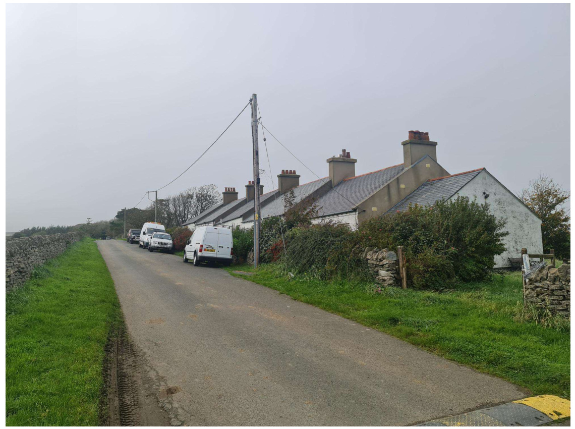
A photograph showing a rural road lined with a stone wall on the left and a row of white-walled farm buildings on the right, with several white vans parked along the side.
The new footpath network will be connected to the existing farm track towards the western site boundary (field 315926). Ecology Vannin has considered the proposed benches/seating in this area and advises that it is an appropriate location.
The section of existing farm track to the south of the stream will be planted with new trees.
Integrated swift nestboxes will be used in place of previously proposed sparrow nestboxes, and will be doubled in number.
Ecology Vannin has advised that the open fronted car port building will provide sufficient nesting opportunities for swallows and that they are satisfied with the arrangement.
6. Highways; the TA has been updated in order to address the consultation responses of DoI Highways Division, and the TP has been amended where necessary. Changes to the proposed scheme include;
An Accessibility Audit is provided with the Design & Access Statement.
A study of pedestrian routes into Peel has been undertaken, including likely routes to school, and improvements (such as dropped kerbs) are now proposed where appropriate. This is explained further in the TA Addendum.
Relatively minor changes have been made to highway layout within the site, including the alteration of bend radii and visibility splays where necessary and the flipping of the driveway for plot B71.
An adopted highway plan is now included with the application.
Additional traffic calming measures have been introduced.
The highway bend adjacent to plots B17-B19 has been re-aligned so to avoid conflict between the forward visibility splay and the parking area for the dwellings.
The access road to plots B90-B92 has been re-aligned to improve forward visibility for users.
An assessment of the Tynwald Road/Albany Road/Queens Drive/Douglas Road junction has been undertaken and is considered in the TA Addendum.
Not all of the points raised by DoI have resulted in changes to the scheme. For example, as stated above the existing access lane to Ballaterson Farm will continue to serve the farmhouse only and its use will not be intensified by the proposed development. This may not have been clear in the submitted drawings, and changes suggested due to this lack of clarity have not necessarily been incorporated.
7. Drainage; the proposed temporary STP will be located below ground, whilst the pump control mechanism will be housed in a discreet GRP kiosk which is usual for residential schemes. The surface water drainage system will incorporate SUDS features such as underground water attenuation. Surface water run-off during construction is considered in the submitted CEMP.
8. General Development Considerations; a number of other points raised in consultation have been addressed;
The affordable dwellings on plots B10 – B16 have been moved back from the highway in order to increase separation distances to the fronts of dwellings on the opposite side of the road;
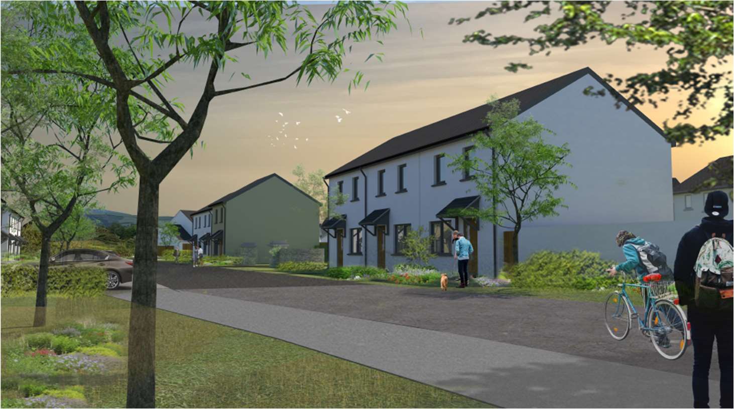
A computer-generated artist's impression showing a street scene with proposed new residential dwellings, landscaping, and pedestrians.
The dwellings on plots B01-B02 have been moved back from the highway as suggested. Their positioning is intended to strengthen the entrance to the development and encourage slower traffic speeds by creating a more intimate sense of space. The image below shows that particular street scene when viewed from the south;
Other dwellings, for example on plot B78, have intentionally been positioned slightly closer to the highway in order to better screen the rear elevation of adjacent dwellings and this can be achieved without compromising the character of the street scene. It should be noted that the Santon house type has a front facing gable section with an additional canopy, and that the main front elevation is set back further than might first be apparent on the site plan;
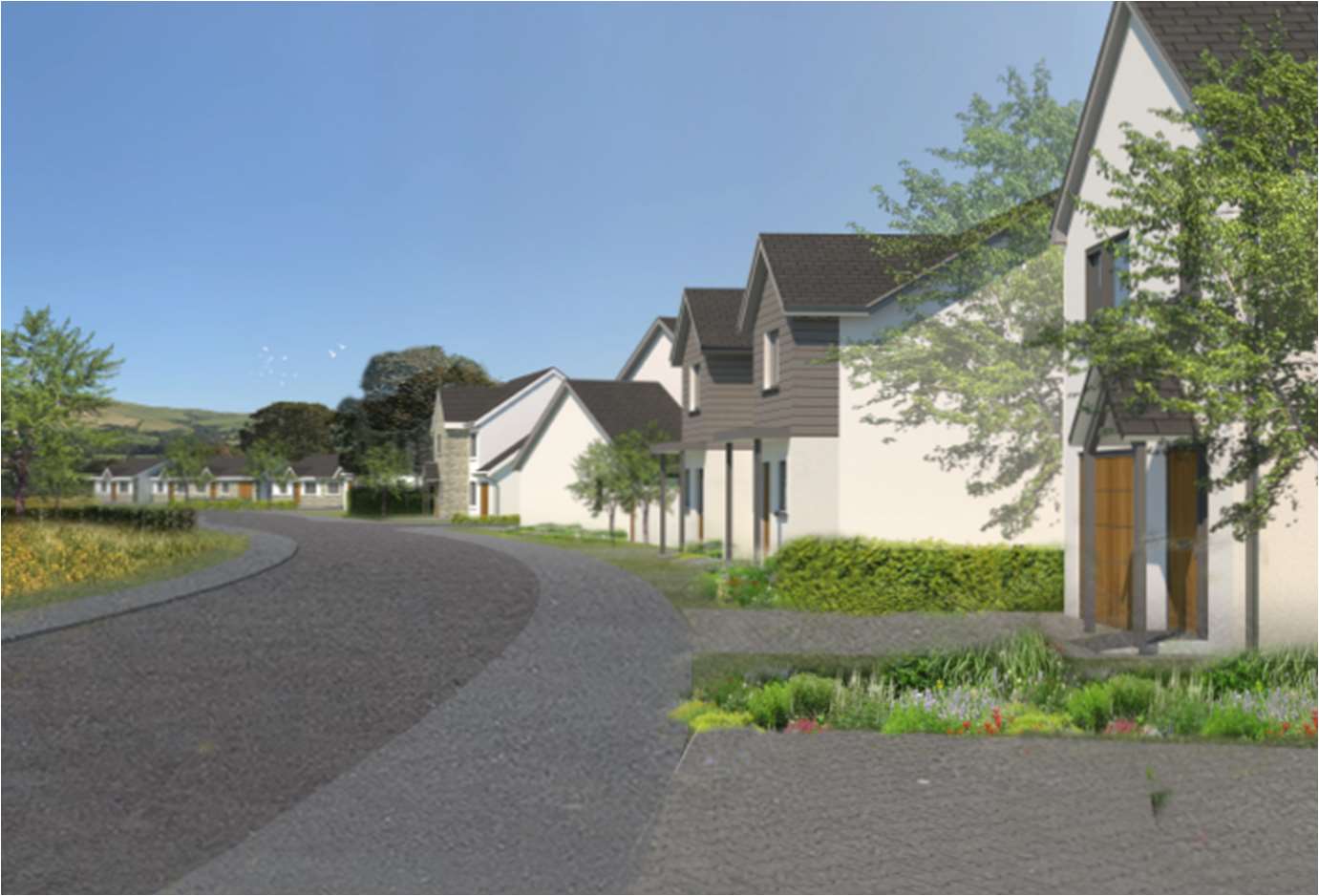
A photorealistic architectural rendering showing a proposed residential street with detached houses, paved roads, and landscaping.A 3D architectural rendering depicting a row of modern semi-detached houses along a curved road with landscaping and trees.
Peel Golf Club was consulted during the design process and provided advice on how to avoid conflict between residential and golf course uses. The distance between the single storey dwellings proposed for plots B55
– B57 and their rear boundaries, and the provision of a landscaped bund at the boundary (see drawing GFB2_APL_50 A) will minimise potential conflict and avoid the need for safety netting/fencing. The Golf Club has indicated that it is content with the proposed arrangement.
A Historic Environment Assessment of the site has been undertaken by Fenix Heritage and the report accompanies the planning application.
The site cannot be seen from any point within the Peel Conservation Area, and the proposed development will not have an adverse impact upon views into or out from the CA (IoMSP Environment Policy 36).
Appendix 2 Energy Impact Assessment/Statement
Energy Impact Assessment
Background The ‘Isle of Man Strategic Plan, 2016’ states:
Energy – Policy 5: ‘The Department will prepare a Planning Policy Statement on Energy Efficiency. Pending the preparation and adoption of that PPS the Department will require proposals for more than 5 dwellings or 100 square metres of other development to be accompanied by an Energy Impact Assessment. (1)
The above Policy Statement is further defined with the following:
12.2.10 ‘In addition to alternative sources of energy supply, the Strategic Objectives in Chapter 3 refer to the promotion of efficiency and economy in the use of resources and the reduction of energy consumption by more efficient use of energy through energy conservation, recycling and waste reduction. There are numerous ways of increasing energy efficiency and reducing energy consumption both in the design and construction of new development and its subsequent operation, management and maintenance. The Building Regulations set standards for energy efficiency in new buildings including walls, windows, roofs and heating appliances. But the design and layout of new developments can in themselves reduce energy consumption through for example Passive Solar Estate Layouts. (2) Added to this are the various solar panel, photovoltaic cell, solar energy and heat pump technologies. (1)
12.2.11 ‘Within the Strategic Objectives relating to resource and to energy efficiency, the Department wishes to promote a greater awareness and recognition, of the benefits both to the environment and the consumer of energy efficiency in its widest sense. To this end the Department intends to prepare a Planning Policy Statement on Energy Efficiency. In the meantime it will require a planning application for more than 5 dwellings or commercial development of more than 100 square metres to be accompanied by an Energy Impact Statement(3) to demonstrate what measures have been taken in the design of the development to reduce energy consumption and increase energy efficiency. (1)
(1) Isle of Man Strategic Plan 2016
(2) UK Department of the Environment General Information Report 27 – Passive Solar Estate Layout
(3) Definition From Appendix 1 of Isle of Man Strategic Plan 2007 – ‘Energy Impact Statement: An assessment, prepared by the developer/applicant, of the impacts of the development in terms of energy consumption and proposals for reducing that consumption and improving the energy efficiency of the development.’
This Energy Impact Assessment/Statement addresses the provisions of Energy Policy 5 of the Isle of Man Strategic Plan.
The headings for the Energy Impact Assessment have been drawn from the following documents:
Town and Country Planning Act 1999 – Isle of Man Strategic Plan 2016 UK Communities and Local Government documents: ‘Code for Sustainable Homes – A Step-change in sustainable home building practice’ . ‘Regulatory Impact Assessment Energy Performance of Buildings Directive Articles 7-10’ BRE BREEAM Ecohomes Standards and Sustainability Checklist (including Pre-Assessment Estimator) Sustainability Checklists – Woking Borough Council Energy Saving Trust – Passive Solar Estate Layout (specifically referred to in 12.2.10 of the Strategic Plan) Town & Country Planning Association (TCPA) ‘Planning for Sustainable Energy’
Dandara Homes – Energy Impact Assessment
SCHEME: Glenfaba Phase 2
Category
Target
Notes
Achievable (YES / NO)
If YES – how? If NO – why not?
Notes
Design / Specification Energy / CO2
Improve thermal efficiency of the walls, windows and roof by eg. more insulation or better glass
Does the design specification demonstrate an improvement over currently utilised specifications / exceed current Building Regulation requirements?
YES
Fabric insulation value exceeds Building Regulation requirements.
Reduce air permeability – improving the control of fresh air into the home
Specific attention paid to the prevention of uncontrolled ventilation. Passive Ventilation methods also considered.
YES
Air tightness testing to samples of units will demonstrate robust construction sealing methodology to ensure air permeability is reduced to meet SAP calculation requirements.
≤1.3 Heat Loss Parameter (HLP)
Fabric of the home designed to reduce thermal bridging.
YES
The properties are detailed to minimise linear bridging around openings and floor slabs and at eaves level with maximum thermal insulation continuity.<br><br>
Reduce Energy Consumption in respect of Space Heating
High efficiency condensing boilers – SEDBUK rating A<br> Alternative (oil/LPG boilers)– SEDBUK rating A<br> Alternative methods of heating eg. Biomass, CHP, Heat Pump<br>
YES NO NO
Not applicable to this scheme. Not applicable to this scheme. Dandara propose to install air source heat pumps to service heating and hot
Category
Target
Notes
Achievable (YES / NO)
If YES – how? If NO – why not?
Notes
Design / Specification Energy / CO²
Improve thermal efficiency of the walls, windows and roof by eg. more insulation or better glass
Does the design specification demonstrate an improvement over currently utilised specifications / exceed current Building Regulation requirements?
YES
Fabric insulation value exceeds Building Regulation requirements.
Reduce air permeability – improving the control of fresh air into the home
Specific attention paid to the prevention of uncontrolled ventilation. Passive Ventilation methods also considered.
YES
Air tightness testing to samples of units will demonstrate robust construction sealing methodology to ensure air permeability is reduced to meet SAP calculation requirements.
≤1.3 Heat Loss Parameter (HLP)
Fabric of the home designed to reduce thermal bridging.
YES
The properties are detailed to minimise linear bridging around openings and floor slabs and at eaves level with maximum thermal insulation continuity.
Reduce Energy Consumption in respect of Space Heating
• High efficiency condensing boilers – SEDBUK rating A • Alternative (oil/LPG boilers)– SEDBUK rating A • Alternative methods of heating eg. Biomass, CHP, Heat Pump
YES NO NO
Not applicable to this scheme. Not applicable to this scheme. Dandara propose to install air source heat pumps to service heating and hot
Passive Solar design<br> Communal heating<br>
NO<br><br>NO
water provision within the property and PV panels will be installed.<br><br>Properties have been orientated to make maximum use of solar gain. Not applicable to this scheme.
Reduce Energy Consumption in respect of water heating
Inclusion of solar thermal water heating OR Properties to be left ‘solar enabled’ for retro-fit.
YES
PV panels will be installed to all dwellings which can provide a contribution towards electric use within properties including hot water via the air source heat pump<br><br>
Improved energy efficiency of lighting (internal)
≥75% energy efficient fixed fittings OR state %.
YES
Energy efficient LED light fittings provided throughout each dwelling.
Improved energy efficiency of lighting (external)
External lighting provided by dedicated energy efficient fittings & daylight cut-off devices.
YES
Energy efficient light fittings provided to external light fittings .
Improved energy efficiency of lighting (security)
All burglar security lighting is Max. 150w & fitted with movement detecting & daylight shut-off devices.
NO
No security lighting provided.
Energy Efficient fixed fittings
≥40% 0f fixed fittings – fridges and freezers have an A+ rating.<br> Washing machines and dishwashers have an A<br>
YES<br><br>YES
Where provided by developer.
• Passive Solar design • Communal heating
NO NO
water provision within the property and PV panels will be installed.
Properties have been orientated to make maximum use of solar gain. Not applicable to this scheme.
Reduce Energy Consumption in respect of water heating
Inclusion of solar thermal water heating OR Properties to be left ‘solar enabled’ for retro-fit.
YES
-PV panels will be installed to all dwellings which can provide a contribution towards electric use within properties including hot water via the air source heat pump
Improved energy efficiency of lighting (internal)
≥75% energy efficient fixed fittings OR state %.
YES
Energy efficient LED light fittings provided throughout each dwelling.
Improved energy efficiency of lighting (external)
External lighting provided by dedicated energy efficient fittings & daylight cut-off devices.
YES
Energy efficient light fittings provided to external light fittings .
Improved energy efficiency of lighting (security)
All burglar security lighting is Max. 150w & fitted with movement detecting & daylight shut-off devices.
NO
No security lighting provided.
Energy Efficient fixed fittings
• ≥40% Of fixed fittings – fridges and freezers have an A+ rating. • Washing machines and dishwashers have an A
YES YES
Where provided by developer.
rating.<br><br> Washer driers & tumble driers have a B rating.
YES
Energy Efficient fittings (retro purchased)
Information provided to the purchaser on the benefits of purchasing energy efficient white goods where not supplied with the new home.
YES
Information is provided within the ‘handover pack’.
Reduce CO2 Emissions
Provide safe, weather-proof & secure cycle storage
YES
Dwellings/plots provide space which can be used for Cycle Storage where required
Reduce CO2 Emissions
Provide a room or space in a quiet room, that can easily be set up as a home office.
YES
Space provided for home office where appropriate
Reduce Energy Consumption
(10%) of total energy demand is supplied from local renewable or low carbon energy sources eg. solar pv, wind turbines.
YES
Photovoltaic panels installed and air source heat pumps
Reduce energy consumption
Provide FOC or for purchase or provide information – Smart Meters (visible display of energy consumption)
YES
Information provided within the ‘handover pack’.
Design / Specification Water
Reduce water consumption target 120l/p/d (litres per day OR
6/4 dual flush toilet
YES
Fitted as standard
rating. • Washer driers & tumble driers have a B rating.
YES
Energy Efficient fittings (retro purchased)
Information provided to the purchaser on the benefits of purchasing energy efficient white goods where not supplied with the new home.
YES
Information is provided within the ‘handover pack’.
Reduce CO2 Emissions
Provide safe, weather-proof & secure cycle storage
YES
Dwellings/plots provide space which can be used for Cycle Storage where required
Reduce CO2 Emissions
Provide a room or space in a quiet room, that can easily be set up as a home office.
YES
Space provided for home office where appropriate
Reduce Energy Consumption
(10%) of total energy demand is supplied from local renewable or low carbon energy sources eg. solar pv, wind turbines.
YES
Photovoltaic panels installed and air source heat pumps
Reduce energy consumption
Provide FOC or for purchase or provide information – Smart Meters (visible display of energy consumption)
YES
Information provided within the ‘handover pack’.
Design / Specification Water
Reduce water consumption - target 120l/p/d (litres per day OR
6/4 dual flush toilet
YES
Fitted as standard
LESS (state if aiming to achieve lower)
Reduce water consumption target 120l/p/d (litres per day) OR LESS (state if aiming to achieve lower)
6-9 litres per minute shower (note – average electric shower is approximately 6/7 litres per minute).
YES
All taps/showers fitted with flow restrictors.
Reduce water consumption target 120l/p/d (litres per day) OR LESS (state if aiming to achieve lower)
18ltr max. volume dishwasher.
YES
Lower (where provided by developer).
Reduce water consumption target 120l/p/d (litres per day) OR LESS (state if aiming to achieve lower)
60ltr max. volume washing machine.
YES
Where provided by developer..<br><br>
Reduce water consumption target 120l/p/d (litres per day) OR LESS (state if aiming to achieve lower)
Provide a system to collect rain water for use in external irrigation / watering (eg. water butts).
NO
Not applicable to this scheme.
Reduce water consumption target 120l/p/d (litres per day) OR LESS (state if aiming
Grey Water Technology (collection and use of bath water etc. for toilet flushing).
NO
Not applicable to this scheme.
LESS (state if aiming to achieve lower)
Reduce water consumption - target 120l/p/d (litres per day) OR LESS (state if aiming to achieve lower)
6-9 litres per minute shower (note – average electric shower is approximately 6/7 litres per minute).
YES
All taps/showers fitted with flow restrictors.
Reduce water consumption - target 120l/p/d (litres per day) OR LESS (state if aiming to achieve lower)
18ltr max. volume dishwasher.
YES
Lower (where provided by developer).
Reduce water consumption - target 120l/p/d (litres per day) OR LESS (state if aiming to achieve lower)
60ltr max. volume washing machine.
YES
Where provided by developer.
Reduce water consumption - target 120l/p/d (litres per day) OR LESS (state if aiming to achieve lower)
Provide a system to collect rain water for use in external irrigation / watering (eg. water butts).
NO
Not applicable to this scheme.
Reduce water consumption - target 120l/p/d (litres per day) OR LESS (state if aiming
Grey Water Technology (collection and use of bath water etc. for toilet flushing).
NO
Not applicable to this scheme.
to achieve lower)
Construction
Materials
Building materials sourced locally where feasible.<br> Materials from recycled sources.<br> Timber from sustainable sources.<br> Insulation materials have zero ozone depletion rate.<br>
YES YES YES YES
All materials are sourced locally where appropriate. Materials are from recycled sources where appropriate. Timber is from sustainable sources where appropriate. Used as standard.
Labour
From local labour pool where feasible.<br> ‘Shared’ transport to site.<br>
YES YES
Local labour is used where possible.
Modern Methods of Construction (MMC)
Off-site construction.
NO
Not appropriate for this scheme.
Waste
Site Waste Management to reduce / reuse / recycle waste.
YES
Standard practice on this construction site.
Occupation
Waste
Provide recycling and storage facilities within/outside the property (multi-bin system) and/or provide an area (with bins) for recycling in line with the Government strategy (subject to inclusion of collection from the designated area by the local council/Government system).
YES
This is subject to further discussion with the Local Authority in line with their recycling collection policy<br><br>
Waste
Provide composting facilities – for each property or communally.
NO
Not applicable to this scheme.
to achieve lower)
Construction
Materials
• Building materials sourced locally where feasible. • Materials from recycled sources. • Timber from sustainable sources. • Insulation materials have zero ozone depletion rate.
YES YES YES YES
All materials are sourced locally where appropriate. Materials are from recycled sources where appropriate. Timber is from sustainable sources where appropriate. Used as standard.
Labour
• From local labour pool where feasible. • ‘Shared’ transport to site.
YES YES
Local labour is used where possible.
Modern Methods of Construction (MMC)
Off-site construction.
NO
Not appropriate for this scheme.
Waste
Site Waste Management to reduce / reuse / recycle waste.
YES
Standard practice on this construction site.
Occupation
Waste
Provide recycling and storage facilities within/outside the property (multi-bin system) and/or provide an area (with bins) for recycling in line with the Government strategy (subject to inclusion of collection from the designated area by the local council/Government system).
YES
This is subject to further discussion with- the Local Authority in line with their recycling collection policy
Waste
Provide composting facilities – for each property or communally.
NO
Not applicable to this scheme.
Reduce energy & water consumption
Provide simple user guide, (non technical) for the occupier on the operation and environmental performance of their home, including tips on how to reduce energy & water consumption.
YES
Information provided in the ‘handover pack’.
Reduce CO2 Emissions
Provide information for the occupier in respect of local alternative means of transport, cycle routes and local amenities (doctor, schools, shops etc.)
YES
Information provided in the ‘handover pack’.
Reduce Carbon Footprint
Inclusion of planting schemes.
YES
As per the landscaping plan
Appendix 3 Economic Impact Statement
Dandara Homes Limited Development of Land Adjacent to Castle View Nursing Home, Glenfaba Rise and Peel Golf Course with a Scheme of 92 Dwellings, Highways and Drainage Infrastructure and Public Open Space; and Re-development of Redundant Farm Building Group at Ballaterson Farm with Replacement Dwelling and Conversion of Outbuildings to Form Tourist Accommodation Statement in Respect of Economic Impact
1. Supplementary planning guidance in respect of economic issues was published by DEFA (the Department) in December 2022. It is stated within the Introduction that “The Isle of Man Economic Strategy (GD No. 2022/0080) was approved by Tynwald in November 2022. The 10-15 Year Strategy seeks to, “…to build a strong and diverse economy, which is sustainable, ambitious and built on firm foundations to provide economic success, rewarding career opportunities and prosperity which positively impacts all residents on the Isle of Man” (Foreword). The strategy is capable of being a material consideration in the determination of planning applications. You may therefore wish to consider if/how your application would contribute to the delivery of the strategy and explain this within your planning submission”.
2. Planning permission is being sought by Dandara Homes Limited to develop land on the western side of Peel with a scheme of 92 dwellings, along with the redevelopment of the redundant farm building group at Ballaterson Farm with a replacement dwelling and the conversion of outbuildings into tourist accommodation, which together will have an estimated Gross Development Value of around £39.5 million. This Statement considers the potential economic impact of the scheme against key issues identified in the supplementary planning guidance.
3. Employment Opportunities and Labour Market (IoMSP Strategic Objective 3.4(a), IoMSP Business Policy 1, Economic Strategy Objective 1); it is estimated that the proposed development will create/safeguard around 100 jobs in the construction sector. This excludes indirect jobs in the supply chain, but a
£39.5m scheme will help to secure jobs in those sectors. It has the potential to grow the economically active population through the provision of new residential accommodation.
4. Supply of Land for Economic Development (IoMSP Spatial Plan, IoMSP Business Policies 2, 3, 5, 7, 9 & 11, Employment Land Review); the application site is zoned for Predominantly Residential use in the extant Development Plan, and as such the provision of 92 new dwellings accords with the provisions of the Plan. The re-development of the farm building group as proposed is in accordance with the relevant policies of the IoM Strategic Plan. The development as proposed will not conflict with nearby land uses – it will adjoin an existing phase of residential development (Glenfaba Rise) and has the potential to support existing retail and leisure uses in the area.
5. Structure of the Economy (Economic Strategy Objectives 2-4); the development proposal will create new business in the key/enabling sectors of year-round tourism and property. The development will be the subject of Building Regulations which will require the use of low and zero carbon installations (with the required SAP value to be increased further in January 2024). The thermal performance required for the external insulated envelope, including glazing, is also set to be revised in the near future.
6. Interaction with other Business (Economic Strategy Objectives 2-4); as well as the extensive use of local businesses and suppliers during construction, going forward the tourism and property elements of the scheme will use local businesses for their supply and servicing requirements, thus strengthening the local supply chain. It will result in a nett increase in the availability, capacity and robustness of on-Island infrastructure in those sectors.
7. For the reasons outlined above the development as proposed would contribute positively to the delivery of the approved Isle of Man Economic Strategy.
Dandara Homes Limited January 2024
Dandara Homes Limited, Isle of Man Business Park, Cooil Road, Braddan, Isle of Man, IM2 2SA
Copyright in submitted documents remains with their authors. Request removal