Loading document...
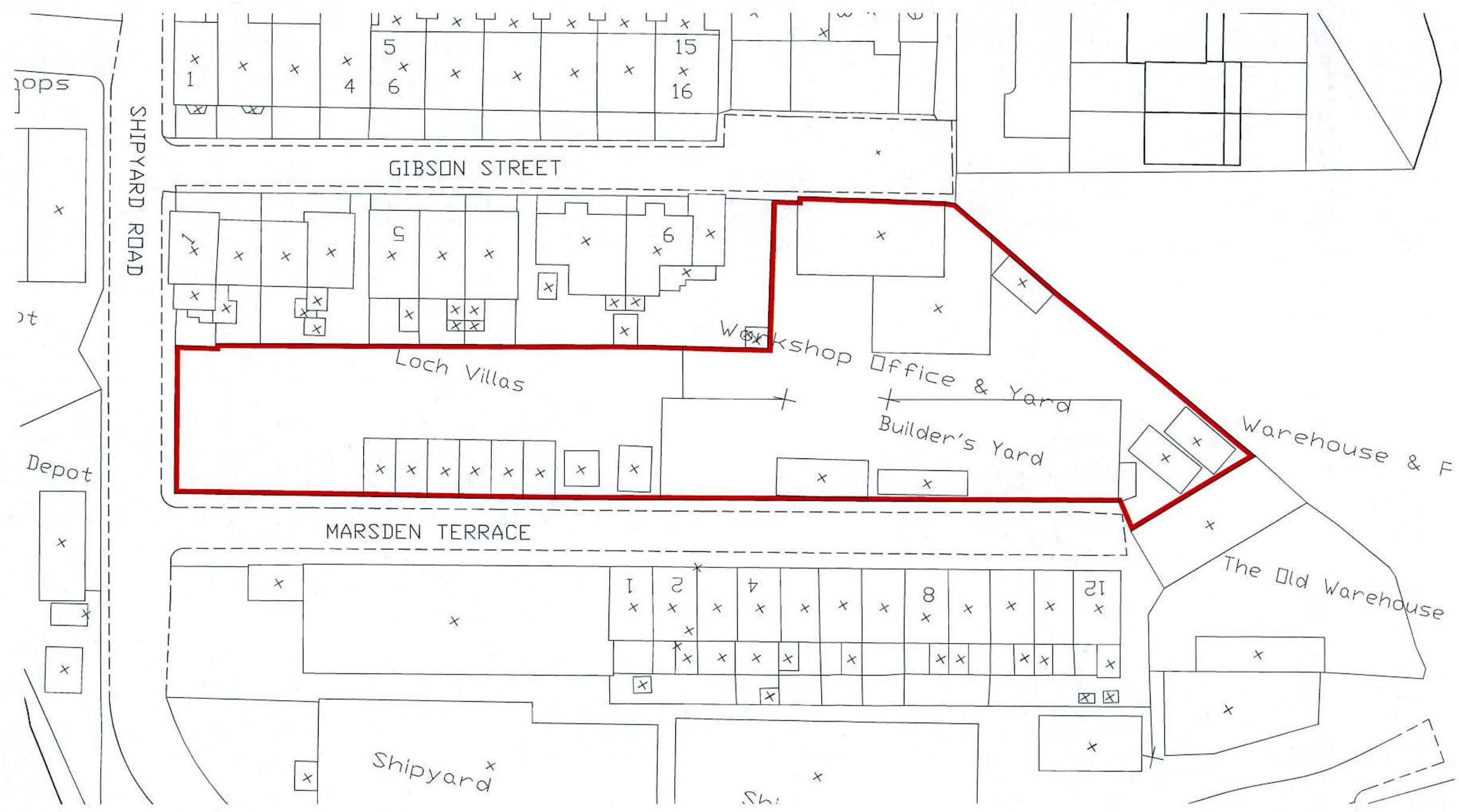
Location Plan
| NEW DATE | DESCRIPTION |
|---|---|
| HUBEI LENGTH INCORRECTS BEDING COLOR: BLANKED SHEET CASTLETOWN SHEI BAI | |
| THORO: HUGOES BANDY SPREAD: PAUL MILLER SIDE: SONICALLOR | |
| CLIENT | |
| Wardaby Limited | |
| INSURED | |
| Redevelopment of Carnes Yard Shipyard Road, Ranlala | |
| MARKING TITLE | |
| Site Location Plan | |
| VENDOR | JD |
| CHECKED | DATE |
| Serial | 13000042 |
| www.hubei.gov.tw | 1701-000 |
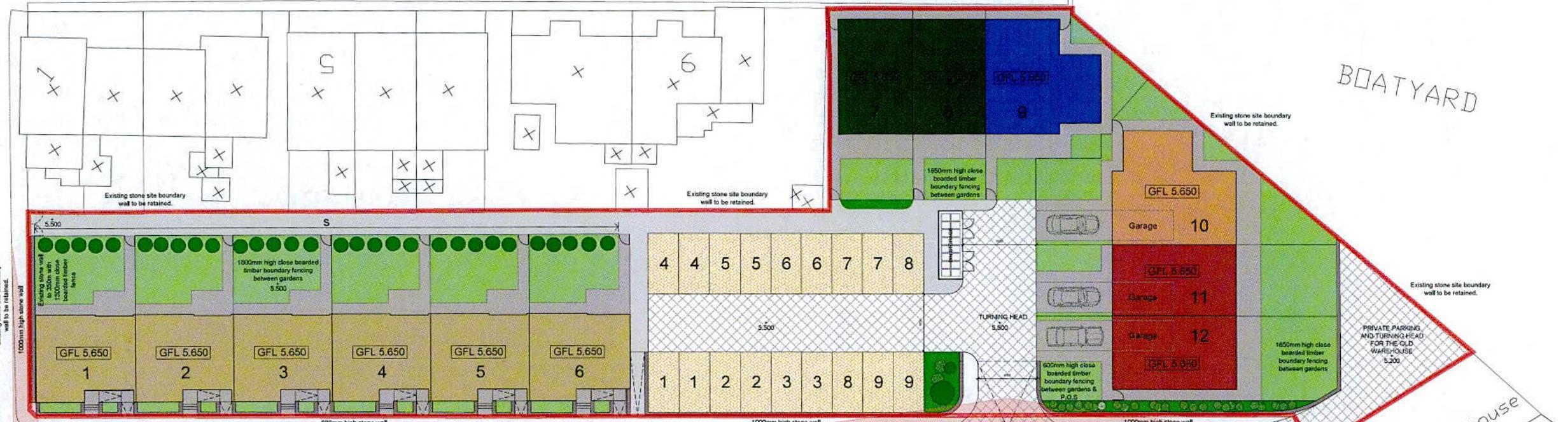
Site Plan as Proposed
GIBSON STREET
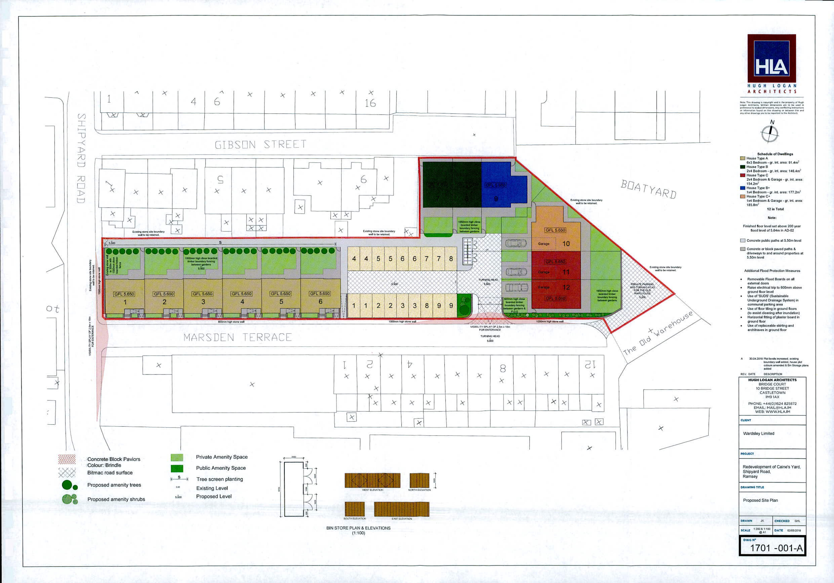
MARSDEEN TERRACE
SIN-STORE PLAN & ELEVATIONS (1:100)
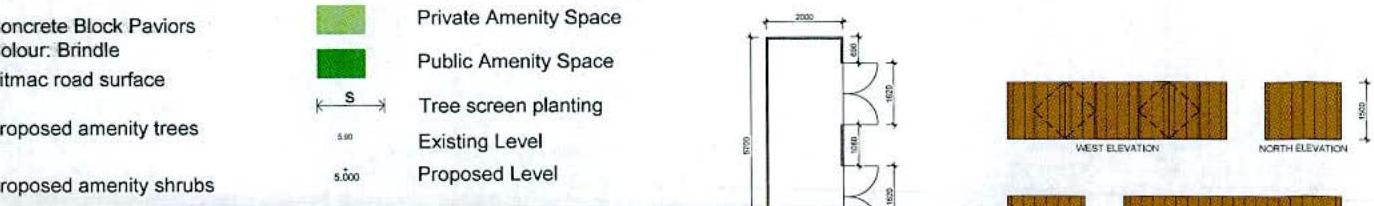
Schedule of Dwellings
☑ Power Type A Not Business - gr. int. area: 91.4m²
☑ Power Type B Not Business - gr. int. area: 146.4m²
☑ Power Type C Not Business - gr. int. area: 177.3m²
☑ Power Type D Not Business - gr. int. area: 177.3m²
☑ Power Type E Not Business - gr. int. area: 177.3m²
10 to Total
Note: Fatalized Blue level set above 200 year Bust level of 6.5km in 45.00
☑ Concrete public paths at 5,50m level
☑ Concrete or block paved paths in attorneys to and around properties at 5,50m level
Additional Fixed Protection Measures
assisted doors
ground Blue level
willingness) (Average Barbers) in commercial parking areas
at street cleaning (Not available)
ground floor
archtrees in ground floor
HIA 3470 WASHINGTON
HIAHOLOGAN ARCHITECTS ARRIVE CENTER HORNOR 27400 CASHLETON PIT 100 PHONE: HANOVER BRIEF EMAIL: HIAHOLOGAN SIDE: WWW.HIAHOLOGAN
PLANT
Wardday Limited
BULLET
Redevelopment of Carne's Yard, Shipyard Road, Ramsey
RECEIVED 3/12
Proposed Site Plan
BILL OF 1701-001-A
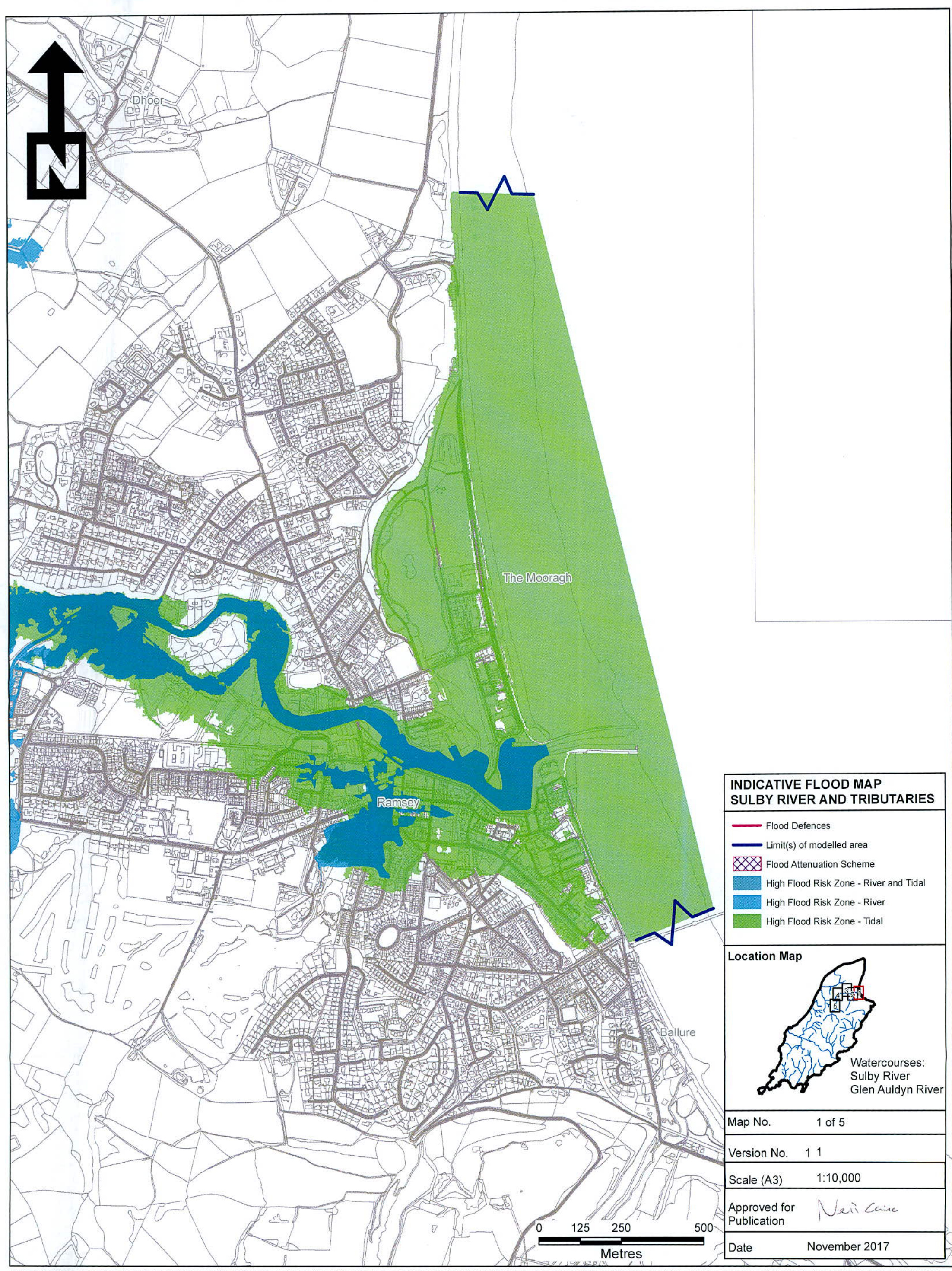
Flood Risk Map Sulby 1 prepared by Manx Utilities
The Flood Map indicates the extent of river flooding associated with a flood event having a chance of occurring in any year ( 1 in 100-year event) and the extent of coastal flooding for the extreme sea level having a chance of occurring in any year ( 1 in 200-year event). In both cases the potential effects of climate change on flood magnitudes are accounted for (by assuming a increase in peak river flows, and taking into consideration the predicted degree of sea level rise based on a 21 / 3 time horizon). The Flood Map indicates where formal flood defences and flood alleviation schemes are in place, and the mapped extents of flooding reflect the influence of flood defences on flood risk. However, defence structures may not completely remove the risk of flooding extreme events. It should also be noted that defences can be breached or fail in extreme weather conditions, and coastal defences can be overlapped by large seams. These additional risk factors are not considered in the Flood Map. The information provided is not an at resolution appropriate for localised flood risk assessments and should not be assumed as definitive at the property scale. Individual properties may, therefore, not always be at the same risk of flooding as surrounding areas/properties. If you believe that a particular property has a different risk of flooding to that shown on the Flood Map and/or if you have information you believe may not have taken into account when preparing the Flood Map please contact Marw Utilities. As an when additional relevant information becomes available to Marw Utilities, the Flood Map will be improved and updated. Marw Utilities reserve all intellectual property rights associated with the Flood Map. Marw Utilities believe that the Flood Map, and information contained therein, accords with the information currently available to it but no representations or warranties (express or implied) are given with regard to its accuracy. To the fullest extent permitted by law Marw Utilities will not accept liability for any losses resulting in connection with the Flood Map. Unauthorised reproduction infringes copyright and may lead to prosecution or civil proceedings. Mapping is based upon the Isle of Man survey map with permission of the Department of Infrastructure, © Crown Copyright Department of Infrastructure, Isle of Man.
Email of 14 March 2018 from Manx Utilities
Wade, Ian <[email protected]> 14 March 2018 16:01 Hugh Logan Stephen Harrison RE: Caine's Yard, Marsden Terrace, Ramsey
Dear Hugh, Further to your email, I can confirm the following:-
If you have any queries please do not hesitate to contact me. Regards Ian
Ian Wade Drainage Planning Engineer Projects \& Strategic Planning Section
"Delivering Life's Essential Services for our Island" PO Box 177 - Douglas - Isle of Man - IM99 1PS - British Isles t: +44(1624)693511 - e: [email protected] m: +44(7624) 451678 - w: www.manxutilities.im
Letter dated 11 May 2018 from Caine Bros Limited
Shipyard Road Ramsey Isle of Man, IM8 3DR Tel: 01624813172 Fax: 01624819120
IIth May 2018 The Secretary of the Planning Committee Department of Infrastructure Murray House Mount Havelock Douglas Re: Planning Application for the Demolition of a Builders Yard and the Construction of Twelve Houses with off Street Car Parking, Garages and Refuse Storage between Gibson Street and Marsden Terrace off Shipyard Road, Ramsey.
We write in relation to the above application. Following the acquisition of Caines Bros (Builders) Ltd from the then Directors it's ownership was transferred to the Current Managing Director, Mr M Downey, of other construction and Civil Engineering Companies; namely Tooms Bros (1994) Ltd and Island Drainage and Groundwork Ltd respectively.
Since the acquisition took place the company has continued to trade in its own right in accountancy terms but has looked to create efficiencies whilst working alongside the other companies forming the "group".
To this end the use of separate depots has been reduced to allow a more centralised and collective approach which in turn bring numerous efficiencies, economic advantage and environmental improvements.
Whilst the builders yard in Ramsey is still utilised to an extent, its importance strategically has diminished through time; the joinery workshop is no longer in use and the general condition of the structures their have deteriorated due to a general lack of use as operations have become more centralised. To all intents and purposes, its use as a builder's yard has become redundant.
For the above reasons this application is being sought in order to offer the opportunity for this location to be redeveloped along the lines of the adjacent and surrounding areas as has been the case in the recent past.
Yours Sincerely
Paul Corteen Director
Copyright in submitted documents remains with their authors. Request removal
View as Markdown