Statement Submitted On Behalf Of Planning And Building Control Division (Department Of Infrastructure)
infrastructure bun-troggalys
PA12/00604/D Erection of illuminated signage, Sea Terminal Building, Victoria Pier, Douglas
Statement prepared by Steven Stanley, BA (Hons), MA (Hons) TRP, MRTPI
Statement on behalf of the Planning and Building Control Division (Department of Infrastructure) in respect of:
PA12/00604/D – Erection of illuminated signage, Sea Terminal Building, Victoria Pier, Douglas
Introduction
In accordance with the provisions of 10.(1)(b) of the Town and Country Planning (Development Procedure) Order 2005 any planning application that proposes development involving land that the Department of Infrastructure could be said to have a vested interest in cannot be determined by the Planning and Building Control Division. In these instances the relevant legislation requires the planning application to be referred to and determined by the Council of Ministers. Such planning applications are dealt with by an appointed person (Planning Inspector) who is charged with assessing the proposed development and reporting their recommendations to the Council of Ministers.
Given the above, this statement is intended to set out the background of the planning application and identify what are considered to be relevant planning policy considerations. In order to avoid any perception of bias the statement purposely makes no assessment of the proposed development and offers no recommendation. The author of this statement intends to attend the inquiry to assist the appointed person where possible.
The Application Site
The site is formed by the curtilage of The Sea Terminal building which includes Victoria Pier, King Edward VIII Pier and the freight area.
The Sea Terminal building and its curtilage is one of the main gateways into the Island.
The Sea Terminal provides facilities for passengers and the general public including a ticket sales office, a convenience shop, Visitor Centre, coffee shop and waiting area.
The Proposal
The proposal seeks planning permission to install three illuminated signs, one on each elevation of the building.
The signs would measure 2430 mm by 600 mm and would have blue backgrounds with white lettering.
Planning History
The site has been the subject of previous planning applications, of which the following is judged to be relevant:
11/00857/D – Erection of four non-illuminated advertising signs. Permitted.
Planning Policy
In terms of land use designation the site lies within an area which was designated as Area of Buildings for Civic, Cultural & Other Special Use – Harbour Related Use by the Isle of Man Planning Scheme (Douglas Local Plan) Order Map No. 1 (Central Area).
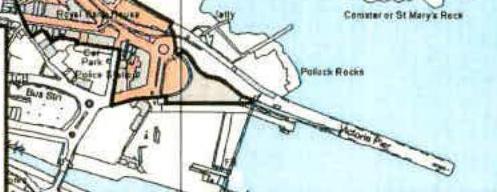
The site is within The Douglas Promenades Conservation Area 2002 (a map showing the extent of this Conservation Area is attached as an appendix to this report).
In terms of strategic plan policy, the following are contained within the Isle of Man Strategic Plan - Towards a Sustainable Island June 2007 and are judged to be relevant to this application:
General Policy 6:
"Within our towns and villages, the display of external advertisements will be permitted on the site or building to which they relate provided they:
(a) are of a high standard of design and materials and relate well to the building and site on which they are to be displayed; (b) are in keeping with and do not detract from the surrounding area; and (c) are located so as not to cause a highway safety hazard."
Environment Policy 37:
"As a general policy, advertisements within Conservation Areas will be permitted only if:
i) the proposal preserves or enhances the Conservation Area; ii) the signage is in a style appropriate to the character of the area; iii) traditional materials and finishes are used and glossy and highly reflective materials are excluded from proposals; and iv) internally illuminated box fascia and projecting box signs are excluded from the proposals."
Recommended Conditions
Should the appointed person be minded to recommend that the application be permitted, the following conditions are recommended:
C1.
The development hereby permitted shall commence before the expiration of four years from the date of this notice.
C2.
This permission relates to the erection of illuminated signage, Sea Terminal Building, Victoria Pier, Douglas as shown by 001, 002, 003 and 004 all received and date stamped 23rd April 2012.
This statement has been prepared by Mr S Stanley BA(Hons), MA(Hons) TRP, MRTPI on behalf of the Planning and Building Control Division (Department of Infrastructure)
JoAuley Date: 17.5.2012
Appendix 1
The Douglas Promenades Conservation Area 2002
The Douglas Promenades Conservation Area
A location map highlighting a specific site boundary in orange near the coast, with visible labels for local landmarks like Pollack Rocks and Admiral Pier.
Map referred to in the Douglas Promenades Conservation Area Order 2002 Made this 9th day of August 2002 Minister for Local Government and the Environment Department of Local Government and the Environment
Copyright in submitted documents remains with their authors. Request removal