Planning Statement For The Erection Of A New Agricultural Building (G) And Proposed New Greenhouse In Place Of Building F, All At Bibaloe Moar, Whitebridge Road, Onchan IM4 5AE
1.0 The site
1.1 Bibaloe Moar Farm sits on the eastern side of Whitebridge Road (A2) as it rises out of Molly Quirk’s Glen dip out of Onchan and towards Baldrine. Access into the site is via an existing drive from the A2. Traffic on the A2 at this point is legally restricted to 40 mph.
1.2 The site accommodates a range of buildings including a farmhouse which sits slightly apart from the farm yard, to the west. A relatively new barn (referred to in the plans as building B) sits to the east of the existing house within a concreted yard. That building has the benefit of planning approval and the recent enforcement notices do not include the concrete yard and as such we are advised that no further permission is necessary for this.
1.3 The land slopes downward from north to south.
1.4 The buildings on site include a house (Building A on the attached plans) which, has recently had works done to it in the form of the replacement of the roof and windows and replacement of the front projecting bay. Other buildings include a large portal framed agricultural building which has been re-sheeted and for which planning approval has been granted (see Planning History below) (Building B) with concreted yard alongside. There are also a number of traditional stone buildings (Buildings C, D, E and F) some of which have had work done to them - some refurbishment, replacement windows and doors and one completely new agricultural building (Building G).
1.5 The Department of Environment, Food and Agriculture Enforcement Officers have contacted the owner of the site in respect of various alleged breaches of planning control, some of which are noted above. Retrospective approval was sought for the cladding of the barn, and granted.
1.6 Until relatively recently there was a large portal framed agricultural building to the south of the existing farmyard but that building has since been removed (see below).
1.7 Planning permission was sought for alterations and extensions to the dwelling house which was permitted (24/91015/B) and simultaneously for regularisation of the works which had been undertaken to buildings C, F and G (24/91016/B). This application was withdrawn following discussions with the planning office. Applications are now submitted for the regularisation of the works to building C, a separate application for the works which have been done to create building G together with proposed works to building F and a third
application is submitted for the erection of a new building (H) to the south of the building group.
1.8 The farm is of some age, the farmyard appearing on the 1860s County Series maps. The dwelling does not appear though, the farmhouse being to the south of the farm group (where the former portal framed building was located) with a large residential curtilage to the east see below. The almost complete courtyard of farm buildings is clearly visible.
1.9 Since the preparation of the plans for the most recent application which was subsequently withdrawn, the agricultural industry has changed and as such, the business model for the holding has been reappraised and as such, the intentions for the farm buildings has been modified and the current suite of applications reflect the applicant’s long term aspirations for this holding. An agricultural business plan accompanies all three applications and explains the role each proposed development will play in the future of the farm.
1.10 The buildings are visible from Whitebridge Road, Groudle Road and Lakeside. From Whitebridge Road it is mainly the house and the rear of building C which is visible:
1.11 From Lakeside and Groudle Road the farm buildings come into clearer view:
1.12 From Bibaloe Beg Road the buildings are not generally publicly visible although may beseen from individual properties which abut this public highway.
2.0 Planning status
2.1 The site lies within an area designated on the Area Plan for the East (2020) as Open Space (which may be for a particular purpose). It is outside of the settlement of Onchan.
2.2 Development in such areas is generally presumed against unless it complies with the following exceptions as set out in General Policy 3 of the Strategic Plan:
(a) essential housing for agricultural workers who have to live close to their place of work; (Housing Policies 7, 8, 9 and 10);
(b) conversion of redundant rural buildings which are of architectural, historic, or social value and interest; (Housing Policy 11);
(c) previously developed land(1) which contains a significant amount of building; where the continued use is redundant; where redevelopment would reduce the impact of the current situation on the landscape or the wider environment; and where the development proposed would result in improvements to the landscape or wider environment;
(d) the replacement of existing rural dwellings; (Housing Policies 12, 13 and 14);
(e) location-dependent development in connection with the working of minerals or the provision of necessary services;
(f) building and engineering operations which are essential for the conduct of agriculture or forestry;
(g) development recognised to be of overriding national need in land use planning terms and for which there is no reasonable and acceptable alternative; and
(h) buildings or works required for interpretation of the countryside, its wildlife or heritage.
and
Environment Policy 1: The countryside and its ecology will be protected for its own sake. For the purposes of this policy, the countryside comprises all land which is outside the settlements defined in Appendix 3 at A.3.6 or which is not designated for future development on an Area Plan. Development which would adversely affect the countryside will not be permitted unless there is an over-riding national need in land use planning terms which outweighs the requirement to protect these areas and for which there is no reasonable and acceptable alternative.
2.3 The Infrastructure Constraints map accompanying the plan shows high voltage electricity lines to the east of the farm buildings.
2.4 The Landscape Character Assessment prepared in 2008 is referred to and summarised in the Written Statement accompanying the Area Plan and states the following about this area of Incised Slopes - Conrhenny and Groudle (the full Assessment is set out in Appendix One):
Landscape Strategy Conserve and enhance:
a) the character, quality and distinctiveness of this area of relatively sparse settlement;
b) its valley bottom woodland;
c) its National Glens;
d) the various archaeological features within the area.
Key Views Dramatic views to an Upland backdrop to the North and West. Dramatic, panoramic views eastwards across the ever-changing colour and nature of the sea and sky, contribute to strongly recognisable sense of place. Close and distant views to the northern edge of Onchan/ Douglas settlement, which is visually harsh in places. Channelled views along the corridor of the Groudle River, which is enclosed in places.
2.5 The site is not within an adopted or proposed Conservation Area.
2.6 The site is not shown as being at risk of flooding, there are no Registered Trees within the site and it is not identified as being ecologically important or sensitive.
2.7 Planning approval may be granted for development which is justified in agricultural terms:
Environment Policy 15: Where the Department is satisfied that there is agricultural or horticultural need for a new building (including a dwelling), sufficient to outweigh the general policy against development in the countryside, and that the impact of this
development including buildings, accesses, servicing etc. is acceptable, such development must be sited as close as is practically possible to existing building groups and be appropriate in terms of scale, materials, colour, siting and form to ensure that all new developments are sympathetic to the landscape and built environment of which they will form a part.
Only in exceptional circumstances will buildings be permitted in exposed or isolated areas or close to public highways and in all such cases will be subject to appropriate landscaping. The nature and materials of construction must also be appropriate to the purposes for which it is intended.
Where new agricultural buildings are proposed next to or close to existing residential properties, care must be taken to ensure that there is no unacceptable adverse impact through any activity, although it must be borne in mind that many farming activities require buildings which are best sited, in landscape terms, close to existing building groups in the rural landscape.
3.0 Planning history
3.1 There have been number of applications submitted for this site:
09/01825/A - approval in principle for a replacement dwelling - refused at appeal for the following reasons:
• The existing house is not of poor form and the replacement was not of a traditional character.
• The size and form of the proposed dwelling would have an unacceptable impact on the character and appearance of the rural area.
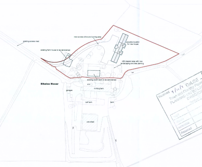
A site plan for a farm property showing existing agricultural buildings, proposed demolition of a farmhouse and dairy barn, and a location for a new house.
• The relocation of the new house would result in the property being more noticeable than the existing and more prominent. The inspector considered that “it is the appellant’s intention to pursue a form of development that would clearly contrary to policy and potentially would have damaging consequences for the countryside. I consider that it would be inappropriate to accept the principle of replacement of the dwelling without a finite scheme that would be acceptable in terms of the policies of the Strategic Plan.”
• The habitable use of the farmhouse was accepted as not having been abandoned.
11/01078/B - alterations to existing vehicular access - permitted
22/01303/B - retrospective application for alterations to agricultural Dutch barn and additional side extension and proposed cladding of barn and extension - permitted
24/91015/B sought approval for alterations to the existing dwelling house and extension to accommodate garaging which was permitted
24/91016/B sought permission for alteration works to stone barns, including: demolition of lean-to extensions to Buildings E and F; partial conversion of Barn C to dwelling; construction of two-storey building between Buildings F and G; single-storey extension to Building F; creation of concrete hardstanding (retrospective)Alteration works to stone barns, including: demolition of lean-to extensions to Buildings E and F; partial conversion of Barn C to dwelling; construction of two-storey building between Buildings F and G; single-storey extension to Building F; creation of concrete hardstanding (retrospective). This application was withdrawn prior to determination.
4.0 The proposal
4.1 Proposed is retrospective approval for physical works and changes of use of some of the buildings within the existing farm group as well as a new greenhouse in place of existing building F.
4.2 The comparative site plans (drawing P0002) shows how the site was laid out previously and may be compared with the current layout which is shown on the same drawing. There were formerly four buildings which have since been demolished and which are no longer on site. These are two small annexes to Buildings C and E, a silo to the rear of Building E and a more sizeable annex to the rear of Building F.
4.3 The building originally where new Building G sits was also demolished, along with the eastern part of original Building F. A new, two storey stone building has been erected in their place (Building G). The extent of the new build footprint - 1127 sq m - is a 4% reduction on what existed in 2006 1176 sq m: the overall floor area represents an increase of less than 10% over what existed in 2006 1721 sq m compared with 1571 sq m.
4.4 Buildings F and G were formerly two separate structures - Building F being attached to the building to the west and L shaped in plan and Building G being a rectangular building sitting detached to the south. Building F has been significantly reduced in area, the southern and rear sections having been demolished and all that remains is a single storey stone building with mono pitch, corrugated sheeted roof. From the rear (north) this appears as a short length of wall where the apex of the roof meets the rear elevation of the building.
4.5 This building is now attached to the new building which replaces Building G. This building is larger in area and height, providing two storeys of accommodation in the northern section and single storey where original Building G was sited.
4.6 No changes are proposed to Buildings B, D and E.
Building F with Building E further back
Building G as built
View of buildings C, D, E and F prior to works being undertaken
View of buildings C, D and E after works were completed
Rear of building G as built
Fronts of buildings E, F and G as built
5.0 Assessment
5.1 The works which have been undertaken relate to a number of different policies within the Strategic Plan. The works are all associated with the renovation of this farm holding which has been farmed in association with adjacent farm holdings for some time with little or no investment in the land or its buildings. The intention is to rejuvenate this holding with a focus on organic farm practices and quality produce in a high quality physical environment.
5.2 The farm holding extends to 161 acres which are currently underused with a previous history of lack of investment. As such the holding needs significant investment in respect of reseeding, fencing and the provision of facilities for the storage of equipment, livestock, feed and accommodation for those working on the farm.
5.3 The holding has now been confirmed as an Eligible Farming Business in respect of Department of Environment, Food and Agriculture support with 0.6 Standard Labour Units. The forage production operation is now to be significantly larger than previously identified.
5.4 An embryonic herd of highland cattle has been purchased in the last 24 months which was expected to have been imported to the Island by now although since November 2023, Department of Environment, Food and Agriculture has suspended the importation of live sheep, cattle and goats from Great Britain in an attempt to manage the spread of Bluetongue to the Island. The herd is currently in the UK in temporary accommodation which is preventing the establishment of the Isle of Man herd. The delay has, however enabled a re-evaluation of what is required and how the farm should be laid out and managed.
5.5 The accompanying Business Plan sets out the long term plan for the holding, including reference to the nature of labour required to manage the enterprise. The nature of the farm business means that during the periods when the herd are calving, there will need to be 24hour supervision to ensure herd welfare and minimise calving losses.The Standard Labour Units calculations demonstrate a total of 4,459 hours and allowing a further 5% extra for management and marketing overheads, the total figure of 4,683 indicates two full time workers will be required, plus either significant seasonal overtime or a third person working part time (to achieve 2.46 Labour Units). This will allow suitable animal welfare cover, even during the critical calving period. It is intended for establish a beef youngstock rearing enterprise comprising commercial beef young stock rearing for sale as young steers or finished stock through the IOM Meat Plant; pedigree young stock rearing for sale as Pedigree Breeding stock and pedigree young stock rearing for retention as replacement
suckler cows for the herd. This is expected to use stock bulls for the commercial young stock production and Artificial Insemination for the pedigree stock.
5.6 The holding presently has one dwelling (the main, original house) and more recently Building C has been renovated and converted to a unit of living accommodation associated with the holding.
5.7 The proposal will not increase the number people on the site nor traffic coming and going thereto. Arguably having more staff facilities on site could reduce the amount of comings and goings. The access has recently been modified with planning approval (see Planning History).
5.8 The planning policies generally presume against development in undesignated areas but there are policies which allow for the construction of agricultural buildings where a need is demonstrated. The accompanying Business Plan explains the future intentions for this holding to bring it back into useful agricultural production. It explains how each of the elements referred to in this application play their part in the enterprise.
5.9 The new building (G) has been traditionally constructed rather than being formed in sheeting over a portal frame. This was intended so that visually the building would sit comfortably within this otherwise traditional stone courtyard. In addition, it is proposed to accommodate both butchery and marketing and packaging operations within the unit which would be less suited to a portal framed, clad building. The building has a number of different entrances and exits with a separate first floor access directly to the upper yard so that anyone working within the non animal handling elements of the business could access and egress the building separately if required.
5.10 It is also proposed to replace the existing building F with a greenhouse. The intention is to grow items and for testing grasses along with producing herbs to compliment the food products generated on site with any remaining space used for seasonal production of fruit and tomatoes for onward sale to local shops and restaurants which might also stock beef products from the site.
5.11 We believe there is agricultural justification for both of these proposed buildings and that as such, they accord with General Policy 3 and Environment Policy 15.
5.12 Given the remote location, the proposals will not have any significant or adverse impact on any neighbours.
5.13 As the site is visible, it is important that any changes thereto retains or reinstates the traditional character and appearance of the site. The works have reinstated the traditional materials found in the buildings on the site and re-established the traditional courtyard layout of the site. As viewed as part of the landscape, we would submit that the form, layout and details of the buildings conserves and enhances the character, quality and distinctiveness of this area as is advocated in the Landscape Character Assessment.
5.14 The proposal will not increase the number people on the site nor traffic coming and going thereto. Arguably having more staff facilities on site could reduce the amount of comings and goings. The access has recently been modified with planning approval (see Planning History).
5.15 Given the remote location, the proposals will not have any significant or adverse impact on any neighbours.
5.16 As the site is visible, it is important that any changes thereto retains or reinstates the traditional character and appearance of the site. The works have reinstated the traditional materials found in the buildings on the site and re-established the traditional courtyard layout of the site. As viewed as part of the landscape, we would submit that the form, layout and details of the buildings conserves and enhances the character, quality and distinctiveness of this area as is advocated in the Landscape Character Assessment.
6.0 Conclusion
6.1 We would submit that the proposal complies with the relevant policies - Environment Policies 1 and 15 as well as General Policy 3 and would result in the re-establishment of an historic group of agricultural buildings to remain a feature of the south facing hillside overlooking Onchan village, preserving the character, quality and distinctiveness of this part of the landscape in accordance with the Character Assessment.
6.2 The proposal is to facilitate the creation of a quality pedigree beef herd and goes beyond the activities found on many farms, including AI processes and quality control over the animals and products, resulting in the need for more robust buildings than the portal framed agricultural buildings which would usually be proposed where new agricultural floorspace is required.
6.3 We believe that the agricultural need for these buildings and this development has been demonstrated and what is proposed, whilst not the conventional portal framed sheeted agricultural building, new building G respects better the character and appearance of the building group which is highly visible and a landmark feature of this hillside. The proposed greenhouse has little or no significant visual impact and would greatly enhance the viability of the holding and its use for its intended agricultural purposes.
Sarah Corlett 22.12.25
Appendix One
Excerpt from the Landscape Character Assessment 2008
D3 CONRHENNY/GROUDLE Key Characteristics
• Gently rolling topography, which is cut by a series of rivers.
• Contain the relatively narrow corridors of the Groudle and Ballacottier Rivers.
• Patchwork of organised pasture and arable fields delineated by a combination of hedgerows, Manx banks and visible drainage ditches.
• Patches of regular coniferous woodland plantations as visible landmarks with the surrounding landscape.
• Distinctive black and white Manx milestones lining the A2 road corridor.
• Series of scattered, isolated farmsteads (several of which have associated modern farm buildings).
• Sense of enclosure provided by Uplands to the north-west.
• Open views to visually harsh red roofs of modern housing developments at the edge of Onchan dominate views southwards.
• Dramatic, panoramic views eastwards across the ever-changing colour and nature of the sea and sky, contribute to strongly recognisable sense of place.
Overall Character Description This character area encompasses gently rolling topography, which is cut by a series of small rivers and streams, including Groudle River and Ballacottier River, which flow north-south across the area. To the north of Onchan, the Groudle River has been dammed to form two triangular reservoirs, Kerrowdhoo and Clypse, which are visible on the horizon on approach to the area. Landscape within the area is covered by a patchwork of organised pasture and arable fields, which are delineated by a combination of hedgerows and Manx banks. Ditches are also characteristically visible at field boundaries in certain locations. Three regularshaped coniferous woodland plantations are situated on sloping land to the northeast of Onchan and provide recognisable sense of place. Set against a dramatic upland backdrop, these woodlands create a sense of enclosure surrounding Conrhenny equestrian centre and provide recognisable landscape features within an otherwise predominantly open landscape. To the south, the area is served by the main A2 road, which runs along the coastline and connects Douglas in the south to Laxey in the north. A series of relatively quiet, rural roads lead northwards from this main road corridor, towards the upland backdrop. Settlement
pattern consists of a series of scattered, isolated farmsteads, several of which have visually intrusive modern farm buildings in proximity to the older, traditional farmhouses. A sense of enclosure is provided by Uplands to the northwest. Overall, there is a relatively strong sense of tranquillity throughout the character area, at distance from major roads corridors and the edges of Onchan. To the north of Onchan, the geometric course of the A18 (TT course), with several viewing platforms and Marshals’ boxes, provides a recognisable transport corridor within the area. The sense of tranquillity is greatly disturbed during TT season. The meandering path of the Groudle River (which is enclosed and wooded in places) abuts the north-eastern edge of Onchan and flows eastwards to join the sea at Port Groudle. Just to the south of this river corridor, King Edward Bay golf course (situated on a prominent hill, and consisting of several areas of rough grassland and heathland) provides a distinct and recognisable landscape feature. In several places, open views to visually harsh red roofs of modern housing developments at the edge of Onchan dominate views southwards. Dramatic, panoramic views eastwards across the ever-changing colour and nature of the sea and sky, contribute to a strongly recognisable sense of place.
Key Views
• Dramatic views to an Upland backdrop to the north and west.
• Dramatic, panoramic views eastwards across the ever-changing colour and nature of the sea and sky, contribute to strongly recognisable sense of place.
• Close and distant views to the northern edge of Onchan/ Douglas settlement, which is visually harsh in places.
• Channelled views along the corridor of the Groudle River, which is enclosed in places.
Historic Features
• St. Adamnan’s/Lonan Old Church
• Standing stones and tumuli
Ecological Features
• Biodiversity value within regular patches of predominantly coniferous woodland.
• Stream corridors.
• Intact network of mature hedgerows.
Evaluation of Inherent Landscape Sensitivities
• Fragmented woodland in valley bottoms.
• Rivers and reservoirs with riparian habitats.
• Scattered settlement pattern of isolated farms and hamlets.
• Sites of archaeological importance.
• Manx Milestones by roadside.
• Well-vegetated character alongside A-roads.
• Victorian Isle of Man Steam Railway and station.
Landscape Strategy The overall strategy is to conserve and enhance the character, quality and distinctiveness of this area of relatively sparse settlement, its valley bottom woodland, its National Glens and the various archaeological features within the area.
Copyright in submitted documents remains with their authors. Request removal