Planning Statement In Respect Of Variation Of Condition 2 Of 21/01313/B To Vary The Hours Of Operation, Manxonia House And Overcliffe, Bay View Road And The Promenade, Port St. Mary Im9 5Da
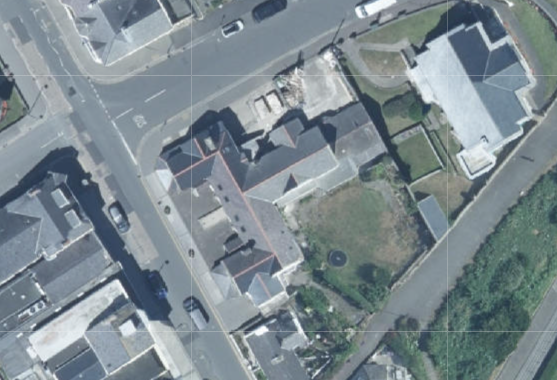
An aerial site plan showing a commercial property complex outlined in red on a street corner, surrounded by other buildings and roads.
1.0 Introduction
1.1 Manxonia House and Overcliffe are conjoined buildings which are approved as being operated as a single unit (see Planning History) which mark the corner of The Promenade and Bay View Road in the heart of Port St. Mary village. Manxonia House sits on the corner and Overcliffe fronts onto The Promenade. To the east of Overcliffe is the Town Hall which provides the local authority’s offices and a community hall above. To the south of Manxonia House is Beach House, an office which is attached to Manxonia House but in separate use and ownership. Manxonia House and Beach House together form a symmetrical, two storey building with projecting gables facing Bay View Road and both having single storey slated, hipped roofed projections forward of the gables.
1.2 Overcliffe is attached to Manxonia House but lower (single storey) with slimmer arch headed windows in the projecting gable which is set back further from the highway than are the gables of the other two properties in the block, and without the single storey addition in front.
1.3 Overcliffe has its frontage open to The Promenade with four parking spaces at right angles to the road available in front of the building.
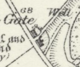
1.4 Overcliffe was thought to be formerly the School House and a group of buildings in this area appear on the 1860s County Series maps (see below). The Conservation Area Appraisal speaks more of this as follows:
“In 1869, the Ordnance Survey map shows a village with only sporadic development between Ballacreggan Farm and the Bay View Hotel. Two pairs of cottages that still stand today, now adjacent to the old school were the first properties on the seaward side of Bay View Road. The next property, some distance away, was a school which was located in the grounds of Ballamona, this later became the first Town Hall. With the exception of a handful
A close-up view of a historical map or site plan showing property boundaries, a gate, and a well feature.
of cottages, there was no other development until the junction with the Lhargan. At this point there was a group of buildings on the lower part of the Lhargan, including the terrace of cottages which remain today.”
“To the north, the frontage to Chapel Bay (now The Promenade) was sold for division into building plots. A new school was opened at the junction of The Promenade and Bay View Road; this has a date plaque of 1880.”
“Opposite is the former school, now occupied as offices, and the adjacent cottages which were built prior to 1869.”
1.4 Across the road from Overcliffe is a public car park where parking is not restricted to any particular period of time but permanent parking is not permitted. Alongside this is a launderette above which is residential accommodation. Alongside this is a vacant development site which had permission for development for a pair of dwellings until 30.04.23 (19/00212/B). Next to this, fronting the corner of The Promenade and Bay View Road is a restaurant and take away, permitted (14/00703/B) to serve food on Tuesdays to Fridays 0800hrs - 1600hrs, on Saturday 0900 - 1600hrs and 0900 - 1400hrs on a Sunday although its current advertisement on the door advises that they are closed Sunday, Monday and Tuesday and the remainder of the week are open 1730 - 2020hrs. The reason given for the control of hours within that approval was “in order to control any potential impact on those living close to the site. The property already has permission for retail sales at the ground floor and as such there should be no further controls over the sale of cold food for consumption off the premises above the current situation which has no hours of operation limitations.”
1.5 The Co-op across Bay View Road is currently open from 0800 - 2200hrs and the restaurants on each side currently or previously operated between 1700 - 2300hrs at the earliest and latest. The former Indian Restaurant on the corner has permission for these opening times (06/01160/B).
1.6 To the south of the Beach House office building are Rose and May Cottages - traditional Manx cottages in residential use. To the south of these is a lane which links Bay View Road with The Promenade and to the south of this are Mona Cottage, Cushag Cottage and Chapel Gate - residential properties.
2.0 Planning policy
2.1 The starting point for the determination of any development proposal is the land use designation. In the Isle of Man this currently takes the form of a variety of plans: the Isle of Man Planning Scheme (Development Plan) Order 1982 was the first development plan which was gradually superseded by a series of local plans in the 1980s and 90s and then in the 2000s onwards, these became Area Plans. The most recent Area Plans cover a large part of the Island and there are adopted plans for the south and east. The remainder of the Island (the north and west) is the subject of an Area Plan which is in the process of preparation and is currently in draft form.
2.2 Area Plan for the South
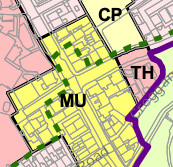
2.2.1 The site lies within an area designated on the Area Plan for the South adopted in 2013, as Mixed Use, reflecting the residential, community, office, retail, food and drink, tourism and recreation uses in the area, and within the proposed Conservation Area (green dashed line - below):
2.2.2 There are no Constraints identified on the relevant map accompanying the Area Plan other than the proposed CA.
A planning map showing land use zones labeled MU, CP, and TH with colored areas and tree symbols.
2.2.3 There are no trees, Registered or otherwise, on the site and the building on the site is not Registered. The site not shown as being at risk of flooding on the national flood risk maps.
2.2.4 The land use designation then leads to policies which guide development. These policies are in both the Area/Local Plans and the Strategic Plan, which is generally a nongeographical policy document applicable to the whole Island.
Area Plan for the South Written Statement
2.2.5 This makes no specific reference to the application site. It refers more generally to Port St. Mary as follows:
2.1.8 The key elements of the Island Spatial Strategy for the South are: regeneration within Castletown, Port St Mary and Port Erin to create further housing, employment and leisure opportunities in keeping with the scale of the settlements.
3.4 The overall strategy for the area is to maintain and enhance the character, quality and distinctiveness of the local built vernacular and integrity of the nucleated settlements of Port Erin, Port St. Mary and Ballagawne5 , the scattered traditional farm dwellings and to maintain the field pattern and semi-upland character of the upper slopes.
3.12.1 Port St Mary is a village of 1,913 people (2006 Census) occupying the coastal area east of Meayll Hill between Perwick Bay and Rhenwyllan Mill. It is classified as a ‘Service Village’ in the Island Spatial Strategy. Retail and business uses are generally small-scale, serving essentially local needs, and there is now only limited tourist accommodation. Renewal and redevelopment of the older built fabric has happened only slowly in recent years, but the Village has managed to retain its attractive appearance, charm and character. There is the possibility that harbour improvements will be undertaken in the future following on from the successful schemes in Douglas and Peel. A comprehensive, sensitively designed scheme which addresses satisfactorily the impacts would result in welcome investment in the Village. This may in turn result in greater use and renovation of the older buildings and enhance the Village’s general character and appeal. The Bay Queen Hotel site clearly needs investment, and would
provide a welcome opportunity for new residential development in Port St Mary. In addition, the older part of Port St Mary is proposed to be designated as a Conservation Area (Map 7).
3.14 ii. It is proposed that there should be a new Conservation Area embracing the older part of the Village around the harbour. This is to be assessed under a different process (see Map 7 for draft boundary).
2.2.6 The Written Statement refers to "some office provision” located primarily within the Mixed Use areas where existing buildings should primarily be used to accommodate them, and provides the following advice about retail use and the vitality of the village:
Mixed Use Proposal 2: Within the Port St Mary Mixed Use area alternative uses to retail use on the ground floor of units may be acceptable if such uses would add to the vitality and viability of the Village. Residential uses will not normally be accepted, subject to the circumstances and merits of such a use. Applications will be considered on their merits taking into account the proposed use, impact on adjacent properties and impact on the character and appearance of the area.
Mixed Use Proposal 4: The upper floors of buildings in the Mixed Use areas of Castletown, Port Erin, Port St Mary and Ballasalla may be appropriate for office use although there will be a presumption in favour of the retention of existing residential uses subject to the circumstances and merits of any alternative uses.
6.18.1 The shops in Port St Mary, strung out sporadically along the main street between the Post Office at one end and The Albert Public House at the other, serve an essentially local need, although the several restaurants attract customers from further afield. The accommodation above the shops is generally used by small businesses as office space, or as apartments. The Port St Mary Local Plan (Draft Written Statement 2001) recognised that the Village centre played a relatively minor role as a retail centre. It would not be beneficial to reserve vacant ground floor shop units for retail use when an alternative use may enhance the vitality of an historic building or the Village centre as a whole (see Mixed Use Proposal 2).
2.2.7 The Plan acknowledges that (6.28.5) “Port St Mary Village remains a popular destination for leisure boats, hikers, and railway travellers, and is of considerable visual attraction, particularly around the inner harbour, Lime Street, and Athol Street.”
2.2.8 The Former “National School” on Bay View Road is identified in the Area Plan Written Statement as worthy of consideration for Registration. The draft Conservation Area Appraisal refers to this group of buildings as set out in the Introduction of this document. The Conservation Area has not been adopted but remains a material consideration and development which would prejudice the designation of the CA should be presumed against.
2.3 Strategic Plan 2016
2.3.1 The Strategic Plan sets out generally non-geographic policies which apply Island wide. There is a general encouragement of sustainable development which is directed to established settlements (Strategic Aim, Strategic Policies 1, 2 and 10, Spatial Policy 5 and Housing Policy 4) with Port St. Mary being one of the nine Services Villages which will, where appropriate increase employment opportunities and where housing should be provided to meet local needs and in appropriate cases to broaden the choice of location of housing (Spatial Policy 3).
2.3.2 The design and appearance of development should be appropriate and of a high quality (Strategic Policies 3 and 5 and Environment Policy 42).
2.3.3 Development in areas designated for development is generally supported, provided that it complies with the following general standards of development:
General Policy 2: Development which is in accordance with the land-use zoning and proposals in the appropriate Area Plan and with other policies of this Strategic Plan will normally be permitted, provided that the development:
(a) is in accordance with the design brief in the Area Plan where there is such a brief;
(b) respects the site and surroundings in terms of the siting, layout, scale, form, design and landscaping of buildings and the spaces around them;
(c) does not affect adversely the character of the surrounding landscape or townscape;
(d) does not adversely affect the protected wildlife or locally important habitats on the site or adjacent land, including water courses;
(e) does not affect adversely public views of the sea;
(f) incorporates where possible existing topography and landscape features, particularly trees and sod banks;
(g) does not affect adversely the amenity of local residents or the character of the locality;
(h) provides satisfactory amenity standards in itself, including where appropriate safe and convenient access for all highway users, together with adequate parking, servicing and manoeuvring space;
(i) does not have an unacceptable effect on road safety or traffic flows on the local highways;
(j) can be provided with all necessary services;
(k) does not prejudice the use or development of adjoining land in accordance with the appropriate Area Plan;(l) is not on contaminated land or subject to unreasonable risk of erosion or flooding;
(m) takes account of community and personal safety and security in the design of buildings and the spaces around them; and
(n) is designed having due regard to best practice in reducing energy consumption.
2.3.4 Sustainable development which reduces journeys and energy use and increases thermal efficiency is now encouraged (Residential Design Guide - which also gives advice about design) and Climate Change Act 2021).
2.3.5 Development is expected to optimise/make the best use of sites (Strategic Policy 1).
2.3.6 Development within Conservation Areas must preserve or enhance the character or appearance of the area (Environment Policy 35 and Planning Policy Statement 1/01 Conservation of the Historic Environment of the Isle of Man CA2) and development outside must not adversely affect key views into or out of the CA (Environment Policy 36). There is a presumption against the demolition of buildings within a Conservation Area which make a positive contribution to the character or appearance of the area.
2.3.7 There are no specific policies regarding food and drink which is within the retail class of uses. Business Policy 9 states that “The Department will support new retail
provision in existing retail areas at a scale appropriate to the existing area and which will not have an adverse effect on adjacent retail areas. Major retail development proposals will require to be supported by a Retail Impact Assessment(1).” (Major development proposals are considered to be in excess of 500 sq m).
2.3.8 The direction of retail uses to settlements is reinforced in Business Policy 10: “Retail development will be permitted only in established town and village centres, with the exceptions of neighbourhood shops in large residential areas and those instances identified in Business Policy 5.”
2.3.9 Development which would create pollution (including that relating to noise) is presumed against (Environment Policy 22).
3.0 Planning history
3.1 The planning history of an area can give an insight into what has previously been considered acceptable and unacceptable and provided there has been no change of circumstance or policy since then, the same conclusion should be reached in any future development proposals.
3.2 In this case, the site has been the subject of the following applications:
3.2.1 88/01754 proposed the conversion of the premises to offices from retail and was permitted
3.2.2 89/01240/B - alteration to create new bathroom - permitted
3.2.3 13/91375 proposed the conversion of the building to entirely residential and with very similar external changes to what is now proposed. This was refused for the reason that: "Whilst the alterations to the property are not considered to be detrimental to the appearance and character of the property (which lies within a proposed Conservation Area), the loss of commercial use of the ground floor would be contrary to the spirit of the Area Plan for the South, Mixed Use Policy 2 and would reduce the range and viability of the village as a service centre and an attractive place to live and visit."
3.2.4 14/00451/B approved the conversion of the existing office accommodation to two dwellings, retention of existing first floor flat and retention of ground floor retail unit, replacement windows and reinstatement of boundary wall. 4.4
3.2.5 17/01153/B replacement of the existing windows in hardwood frames and was approved
3.2.6 18/00534/B - installation of replacement windows - permitted
3.2.7 21/00501/B - conversion of Manxonia House from existing office, residential and retail space to retail (Class 1.1) and tea rooms (Class 1.3) - permitted subject, inter alia to a condition which requires:
No customers shall be served or remain in the building outside the following
hours: 8am - 9pm. Reason: In the interests of public amenity.
It should be noted that the application did not propose any particular opening hours but the planning officer recommends at his paragraph 6.4.3 without any other reference, that the opening hours should be so restricted to ensure that the premies is not open to customers outside the hours of 8am and 9pm to reduce the risk of noise disturbance during unsociable hours. He preceded this with the following comments:
However, the site is within a designated Mixed Use area which seeks to ensure that uses of the type proposed are centralised within town and village centres and to ensure that these centres remain vibrant and viable. Separate licensing and other legislation relating to opening hours and noise nuisance may come into consideration should future issues arise. For the current proposal, noise nuisance on the occupiers of the adjacent properties is not considered likely to be so severe as to warrant a refusal of planning permission.
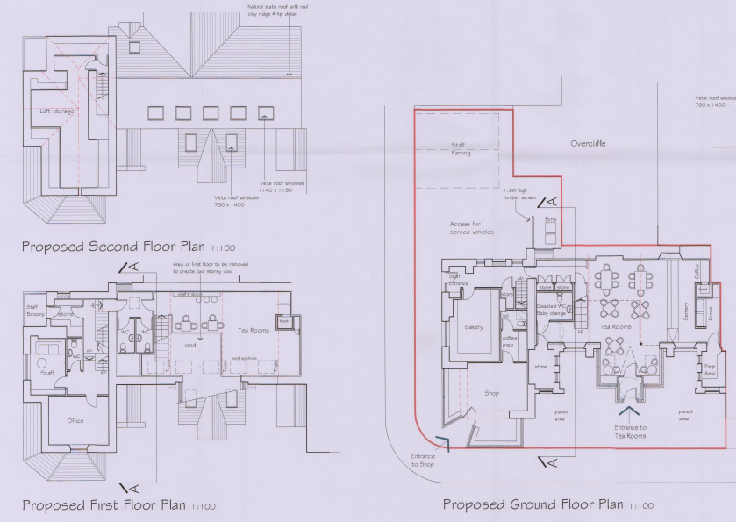
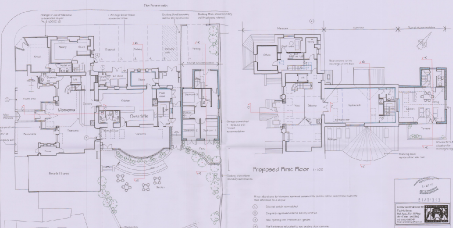
The proposed layout was as follows:
The image displays architectural floor plans for a commercial property, including a ground floor layout with a shop and tea rooms, a first-floor plan with offices, and a roof section.
3.2.8 21/01313/B is described as proposing the conversion of Overcliffe from existing residential and commercial space into retail (class 1.1), tea rooms (class 1.3), restaurant (class 1.3), and tourist accommodation but included the merging of Overcliffe with Manxonia House and use of the unit as a single cafe/restaurant/tea rooms with extension, effectively superseding the previous application solely for Manxonia House (21/00501/B). This application was permitted subject, inter alia to a condition which required:
No customers shall be served or remain in the building outside the following
hours: 9am - 11pm.
Reason: The application has been assessed on this basis as requested in the application and in the interests of public amenity.
The proposed layout was as shown below including tables and chairs in the rear garden area:
This image displays a proposed first-floor architectural floor plan showing room layouts including a kitchen, dining area, living room, bedrooms, and office spaces.
3.2.9 23/00288/B - removal of two chimneys (retrospective) - permitted
4.0 The proposal
4.1 Proposed here is the variation of the condition applied to 21/01313/B which controls the opening hours of both premises. This current application is a single application for both properties as both internally are operated as one planning unit with access to the restaurant in Overcliffe only available through Manxonia House and the first floor restaurant in Overcliffe looking over the tea room in Manxonia House.
4.2 The current permitted operating hours are different for Manxonia House than for Overcliffe albeit that the later application for Overcliffe refers to the whole site including both properties and as such, supersedes the earlier approval for Manxonia House:
Manxonia House - No customers shall be served or remain in the building outside the following hours: 8am - 9pm.
Overcliffe - No customers shall be served or remain in the building outside the following hours: 9am - 11pm.
4.3 This current application proposes streamlining the operating hours where customers would be able to remain in the building are as follows for both buildings:
0800 - 2345hrs Monday to Sunday inclusive 0800 - 0045hrs on New Year’s Eve/Day
4.3 Music will cease to be played no later than 2330hrs on any day.
4.4 The applicant has had regard to the operating times of the Town Hall which is next door but one to the premises - with the applicant’s tourist accommodation in between and proposed times which coincide with those.
4.5 It should be noted that aside from needing planning approval, a licence will also be required for the serving of alcohol and the playing of any music which the applicants intend to apply for should this planning application be considered positively.
5.0 Assessment
5.1 The site is located within a settlement, in a sustainable location close to existing public transport links and is designated for Mixed Use on the adopted and draft development plans. There should therefore, be a presumption in favour of development here and the best use of the site (Strategic Policy 1) although consideration must be had to the impact of any development on the living conditions of those in nearby properties, particularly residential buildings (General Policy 2 and Environment Policy 22).
4.2 This is particularly the case here where permission has been granted for the alterations and mixed use of both buildings. The principal issues are likely to be the potential impact on adjacent land users, particularly residents from any changes to the building including extension of opening hours where there could be disturbance or nuisance although licensing regulations tend to take account of these issues when issuing permits for the selling of alcohol or playing of amplified music.
4.3 It is also useful that the buildings are identified in the CA Appraisal so their continued use should be particularly supported to ensure their continued maintenance.
4.4 The sensitive adjacent occupants are considered to be those occupying the tourist unit adjacent to the Overcliffe food and drink unit as well as those residents immediately close by
in particular those in Rose Cottage and May Cottage and the residents above the laundrette.
4.5 It is relevant that the town hall hosts sports and events which are not believed to have any planning conditions controlling hours of operation and the applicant has aligned their proposed operation to the hours of operation of the town hall. There is an argument that the licensing courts are the proper channel for the consideration of such impacts and that planning conditions should not seek to duplicate other legislation however as may be seen from the examples give in the introduction, the planning process can and does apply time limits to certain uses where there is a concern that there could be an impact on others. In any case, there are already time limits imposed on both Manxonia House and Overcliffe. It remains the case that regardless of what timing restrictions are imposed by the planning process, the serving of alcohol or the playing of music will require the applicants to obtain a licence from the Courts who also maintain control of the standard of operation of the premises and any adverse impact that may arise.
4.6 The site lies within a settlement and close to other commercial operations, some of which open until late into the evening. The extended opening hours will allow the facility to increase its viability and to cater to different types of client throughout the day. The tourist accommodation adjacent to Overcliffe is in the same ownership and as such, the applicants have no wish to run a facility which will cause a nuisance or issues for the occupants of that property nor to any other neighbouring property.
4.7 The applicants would intend that the operation of their restaurant and tea room contribute to the amenities available to those who live in and visit Port St. Mary and provide a viable use to one of its most interesting buildings within the proposed Conservation Area.
Sarah Corlett 10.10.2023
Appendix One
Relevant Strategic Plan policies
Strategic Aim: To plan for the efficient and effective provision of services and infrastructure and to direct and control development and the use of land to meet the community’s needs, having particular regard to the principles of sustainability whilst at the same time preserving, protecting, and improving the quality of the environment, having particular regard to our uniquely Manx natural, wildlife, cultural and built heritage.
Strategic Policy 1: Development should make the best use of resources by:
(a) optimising the use of previously developed land, redundant buildings, unused and underused land and buildings, and reusing scarce indigenous building materials;
(b) ensuring efficient use of sites, taking into account the needs for access, landscaping, open space(1) and amenity standards; and
(c) being located so as to utilise existing and planned infrastructure, facilities and services.
Strategic Policy 2: New development will be located primarily within our existing towns and villages, or, where appropriate, in sustainable urban extensions(2) of these towns and villages. Development will be permitted in the countryside only in the exceptional circumstances identified in paragraph 6.3.
Strategic Policy 3: Proposals for development must ensure that the individual character of our towns and villages is protected or enhanced by:
(a) avoiding coalescence and maintaining adequate physical separation between settlements; and
(b) having regard in the design of new development to the use of local materials and character.
Strategic Policy 4: Proposals for development must:
(a) Protect or enhance the fabric and setting of Ancient Monuments, Registered Buildings(1), Conservation Areas(2) , buildings and structures within National Heritage Areas and sites of archaeological interest;
(b) protect or enhance the landscape quality and nature conservation value of urban as well as rural areas but especially in respect to development adjacent to Areas of Special Scientific Interest and other designations; and
(c) not cause or lead to unacceptable environmental pollution or disturbance.
Strategic Policy 5: New development, including individual buildings, should be designed so as to make a positive contribution to the environment of the Island. In appropriate cases the Department will require planning applications to be supported by a Design Statement which will be required to take account of the Strategic Aim and Policies.
Strategic Policy 10: New development should be located and designed such as to promote a more integrated transport network with the aim to:
(a) minimise journeys, especially by private car;
(b) make best use of public transport;
(c) not adversely affect highway safety for all users, and
(d) encourage pedestrian movement.
Spatial Policy 5: New development will be located within the defined settlements. Development will only be permitted in the countryside in accordance with General Policy 3.
General Policy 2: Development which is in accordance with the land-use zoning and proposals in the appropriate Area Plan and with other policies of this Strategic Plan will normally be permitted, provided that the development:
(a) is in accordance with the design brief in the Area Plan where there is such a brief;
(b) respects the site and surroundings in terms of the siting, layout, scale, form, design and landscaping of buildings and the spaces around them;
(c) does not affect adversely the character of the surrounding landscape or townscape;
(d) does not adversely affect the protected wildlife or locally important habitats on the site or adjacent land, including water courses;
(e) does not affect adversely public views of the sea;
(f) incorporates where possible existing topography and landscape features, particularly trees and sod banks;
(g) does not affect adversely the amenity of local residents or the character of the locality;
(h) provides satisfactory amenity standards in itself, including where appropriate safe and convenient access for all highway users, together with adequate parking, servicing and manoeuvring space;
(i) does not have an unacceptable effect on road safety or traffic flows on the local highways;
(j) can be provided with all necessary services;
(k) does not prejudice the use or development of adjoining land in accordance with the appropriate Area Plan;
(l) is not on contaminated land or subject to unreasonable risk of erosion or flooding;
(m) takes account of community and personal safety and security in the design of buildings and the spaces around them; and
(n) is designed having due regard to best practice in reducing energy consumption.
Environment Policy 22: Development will not be permitted where it would unacceptably harm the environment and/or the amenity of nearby properties in terms of: i) pollution of sea, surface water or groundwater; ii) emissions of airborne pollutants; and iii) vibration, odour, noise or light pollution.
Environment Policy 35: Environment Policy 35: Within Conservation Areas, the Department will permit only development which would preserve or enhance the character or appearance of the Area, and will ensure that the special features contributing to the character and quality are protected against inappropriate development.
Environment Policy 39: The general presumption will be in favour of retaining buildings which make a positive contribution to the character or appearance of the Conservation Area.
Environment Policy 42: New development in existing settlements must be designed to take account of the particular character and identity, in terms of buildings and landscape features of the immediate locality. Inappropriate backland development, and the removal of open or green spaces which contribute to the visual amenity and sense of place of a particular area will not be permitted. Those open or green spaces which are to be preserved will be identified in Area Plans.
Transport Policy 7: The Department will require that in all new development, parking provision must be in accordance with the Department’s current standards.
APPENDIX TWO Planning Policy Statement 1/01 - Conservation of the Historic Environment of the Isle of Man
POLICY CA/2 SPECIAL PLANNING CONSIDERATIONS When considering proposals for the possible development of any land or buildings which fall within the conservation area, the impact of such proposals upon the special character of the area, will be a material consideration when assessing the application. Where a development is proposed for land which, although not within the boundaries of the conservation area, would affect its context or setting, or views into or out of the area; such issues should be given special consideration where the character or appearance of a conservation area may be affected.
Copyright in submitted documents remains with their authors. Request removal